
Al-Nabi Rubin, was a Palestinian village located 28 kilometers northeast of Acre. Al-Nabi Rubin students used to attend school in the nearby village of Tarbikha.

Suruh, was a Palestinian Arab hamlet, located 28.5 kilometers (17.7 mi) northeast of Acre. It became depopulated in the 1948 Arab-Israeli war.

Hunin was a Palestinian Arab village in the Galilee Panhandle part of Mandatory Palestine, close to the Lebanese border. It was the second largest village in the district of Safed, but was depopulated in 1948. The inhabitants of this village were, similar to the inhabitants of Southern Lebanon, Shia Muslims.
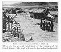
Al-Khalisa was a Palestinian Arab village situated on a low hill on the northwestern edge of the Hula Valley of over 1,800 located 28 kilometers (17 mi) north of Safad. It was depopulated in the 1948 Palestine war.

Lazzaza was a Palestinian Arab village of 230 in the northern Hula Valley next to the Hasbani River, located 27.5 kilometers (17.1 mi) northwest of Safad. Beit Hillel subsequently expanded onto the land.

Mallaha was a Palestinian Arab village, located 16 kilometers (9.9 mi) northeast of Safed, on the highway between the latter and Tiberias. 'Ain Mallaha is the local Arabic name for a spring that served as the water source for the village inhabitants throughout the ages. It is also one of the names used in English to refer to the ancient Natufian era settlement at the site.

Al-Mansura was a small Palestinian Arab village in the Ramle Subdistrict, located 10 km south of Ramla. It was depopulated during the 1947–48 Civil War in Mandatory Palestine on April 20, 1948, under Operation Barak.

Al-'Abisiyya was a Palestinian Arab village in the District of Safad. It was depopulated during the 1948 Arab-Israeli War on May 29, 1948, by The Palmach's First Battalion of Operation Yiftach. It was located 28.5 km northeast of Safad near to the Banyas River which the village relied on for irrigation.

Arab al-Shamalina also known as Khirbat Abu Zayna was a Palestinian Arab village in the Safad Subdistrict. It was depopulated during the 1947–1948 Civil War in Mandatory Palestine on May 4, 1948, under Operation Matate (Broom), a sub operation of Operation Yiftach. It was located 13 km southeast of Safad near the Jordan River.

Fara was a Palestinian Arab village in the Safad Subdistrict. It was depopulated during the 1948 Arab-Israeli War on October 30, 1948, under Operation Hiram. It was located 11.5 km north of Safad on the Wadi al-Fara.

Fir'im was a Palestinian Arab village in the Safad Subdistrict that was depopulated during the 1948 Palestine war. It was first attacked during the 1947–1948 Civil War in Mandatory Palestine on May 2, 1948, by the Palmach's First Battalion during Operation Yiftach. In 1945 the population had been 740.

Al-Shawka al-Tahta was a Palestinian Arab village in the Safad Subdistrict. It was depopulated during the 1947–1948 Civil War in Mandatory Palestine on May 14, 1948, by the Palmach's First Battalion of Operation Yiftach. It was located 31.5 km northeast of Safad.

Al-Na'ima was a Palestinian Arab village in the Safad Subdistrict of Mandatory Palestine located 26 kilometres (16 mi) northeast of Safad, near the al-Hula Plain. The settlement was depopulated during the 1947-1948 civil war on May 14, 1948 by the Israeli Palmach's First Battalion as part of Operation Yiftach.

Al-Zuq al-Tahtani was a Palestinian Arab village in the Safad Subdistrict. It was depopulated during the 1947–1948 Civil War in Mandatory Palestine on May 11, 1948, by the Palmach's First Battalion of Operation Yiftach. It was located 30 km northeast of Safad.

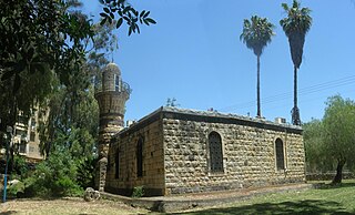
Al-Mansura was a Palestinian Arab village in the Safad Subdistrict. It was located 31 kilometres (19 mi) northeast of Safad on the Banyas River, to the south of what is now Dafna.

Qaytiyya was a Palestinian Arab village in the Safad Subdistrict. It was depopulated during the 1948 War on May 19, 1948, by the Palmach's First Battalion of Operation Yiftach. It was located 28 km northeast of Safad, bordering both the Hasibani and the Dan Rivers.

Al-Qudayriyya was a Palestinian Arab village in the Safad Subdistrict. It was depopulated during the 1947–1948 Civil War in Mandatory Palestine on May 4, 1948, by the Haganah and the Palmach's First Battalion of Operation Matate, a sub-operation of Operation Yiftach. It was located 6.5 km south of Safad, situated 1 km east of Wadi al-'Amud.

Al-Sanbariyya was a Palestinian village in the Safad Subdistrict. It was depopulated during the 1947–1948 Civil War in Mandatory Palestine on May 1, 1948, by Palmach's First Battalion under Operation Yiftach. It was located 31.5 km northeast of Safad, near Wadi Hasibani.

Tulayl was a Palestinian Arab village in the Safad Subdistrict located 14.5 kilometers (9.0 mi) northeast of Safad. It was situated on a hill near Lake Hula. Together with the nearby village of al-Husayniyya, it had a population of 340 in 1945. Tulayl was depopulated during the 1948 Palestine War.

Al-'Ulmaniyya was a Palestinian Arab village in the Safad Subdistrict. It was depopulated during the 1947–1948 Civil War in Mandatory Palestine on April 20, 1948, by the Palmach's First Battalion of Operation Yiftach. It was located 14.5 km northeast of Safad.

 1870s map
 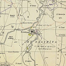 1940s map
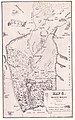
 modern map
 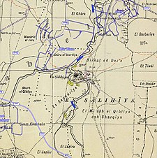 1940s with modern overlay map


