Jilya

Last updated • 2 min readFrom Wikipedia, The Free Encyclopedia
Jilya
جِليا
Village
Etymology: probably from Gallaa [1] [2]
Historical map series for the area of Jilya (1870s).jpg 1870s map
Historical map series for the area of Jilya (1940s).jpg 1940s map
Historical map series for the area of Jilya (modern).jpg modern map
Historical map series for the area of Jilya (1940s with modern overlay).jpg 1940s with modern overlay map
A series of historical maps of the area around Jilya (click the buttons)
Mandatory Palestine location map.svg
Red pog.svg
Jilya
Location within Mandatory Palestine
Coordinates: 31°46′06″N34°51′52″E / 31.76833°N 34.86444°E / 31.76833; 34.86444
Palestine grid 137/130
Geopolitical entity Mandatory Palestine
Subdistrict Ramle
Date of depopulationJuly 9–10, 1948 [3]
Population
 (1945)
  Total330 [4] [5]
Cause(s) of depopulationInfluence of nearby town's fall

Jilya was a Palestinian Arab village in the Ramle Subdistrict of Mandatory Palestine. The Romans referred to it as Jilya by Galla. It was depopulated during the 1948 Arab–Israeli War by the Givati Brigade of the first stage of Operation Dani on July 9, 1948. It was located 17 km south of Ramla.

Contents

History

The PEF's Survey of Western Palestine (SWP) thought that Jilya was the Gallaa of the Onomasticon, mentioned as a town near Accaron . [2]

Ottoman era

Jilya, like all of Palestine was incorporated into the Ottoman Empire in 1517. In the 1596 tax registers, it was listed as an entirely Muslim village, located in the nahiya of Gazza in the liwa of Gazza, with a population of 17 families; an estimated population of 94. [6] [7] The inhabitants paid a fixed tax rate of 33,3% on agricultural products, including wheat, barley, summer crops, vineyards, goats and beehives, in addition to occasional revenues; a total of 2,200 akçe. [6]

In 1882 the SWP described it as "an ordinary village of adobe and stone." [2]

British Mandate era

In the 1922 census of Palestine, conducted by the British Mandate authorities, Jilia had a population of 269, all Muslims, [8] increasing slightly in the 1931 census to 271 Muslims, in 63 houses. [9]

In the 1945 statistics, the population had increased to 330 Muslims, [4] [5] while the total land area was 10,347 dunams, according to an official land and population survey. [5] Of this, a total of 7,677 dunums of village land was used for cereals, 40 dunums were irrigated or used for plantations, [10] while 7 dunams were classified as built-up areas. [11]

Jilya (Jilye) 1930 1:20,000 Qezaze 1930.jpg
Jilya (Jilye) 1930 1:20,000
Jilya 1945 1:250,000 Mansura 1945.jpg
Jilya 1945 1:250,000

1948, aftermath

Jilya was depopulated on July 9–10, 1948. [3] On 16 July 1948, during Operation An-Far, Givati HQ informed General Staff\Operations that "our forces have entered the villages of Qazaza, Kheima, Jilya, Idnibba, Mughallis, expelled the inhabitants, [and] blown up and torched a number of houses. The area is at the moment clear of Arabs." [12] On the July 19th, refugees near Jilya were warned by Israeli forces that they would be killed if they tried to return to their village. [13]

In 1992 it was noted about the village site: "The area is fenced in and inaccessible". [7]

Related Research Articles

<span class="mw-page-title-main">Tarbikha</span> Place in Acre, Mandatory Palestine

Tarbikha, was a Palestinian Arab village. It was located 27 kilometres northeast of Acre in the British Mandate District of Acre that was captured and depopulated by the Israel Defense Forces during the 1948 Arab-Israeli war. The inhabitants of this village were, similar to the inhabitants of Southern Lebanon, Shia Muslims.

<span class="mw-page-title-main">Safsaf</span> Depopulated Palestinian village in present-day Israel

Safsaf was a Palestinian village 9 kilometres northwest of Safed, present-day Israel. Its villagers fled to Lebanon after the Safsaf massacre in October 1948, during the 1948 Arab–Israeli War.

<span class="mw-page-title-main">Al-Malkiyya</span> Place in Safad, Mandatory Palestine

Al-Malkiyya, also known as Al-Malikiyah, was a Palestinian village located in the Jabal Amil region. In a 1920s census, the village was registered as part of Greater Lebanon. It was later placed under the British Mandate of Palestine. Its population was mostly Metawali Shiite.

<span class="mw-page-title-main">Al-Khayriyya</span> Place in Jaffa, Mandatory Palestine

Al-Khayriyya, also Ibn Ibraq, was a Palestinian Arab village located 7.5 kilometers east of Jaffa. It became depopulated in April 1948 as a result of a military assault by the Alexandroni Brigade of the pre-state Israeli forces during the 1948 Palestine war. The village lands would later be used by Israel as the Hiriya landfill.

<span class="mw-page-title-main">Qatra</span> Place in Ramle, Mandatory Palestine

Qatra was a Palestinian Arab village in the Ramle Subdistrict, located 15 kilometers (9.3 mi) southwest of the city of Ramla and 40 kilometers (25 mi) west of Jerusalem, some 50 meters (160 ft) above sea level. It was depopulated in May 1948.

<span class="mw-page-title-main">Barqa, Gaza</span> Place in Gaza, Mandatory Palestine

Barqa was a Palestinian Arab village located 37 km north of Gaza near the modern-day Israeli city of Ashdod. It was referred to as Barka by the Greeks and Bareca by the Romans during their rule over the ancient Philistine city. In 1945, the village had a population of 890 and total land area of 5,206 dunums.

<span class="mw-page-title-main">Jimzu</span> Place in Ramle, Mandatory Palestine

Jimzu, also known as Gimzo, was a Palestinian village, located three miles southeast of Lydda. Under the 1947 UN Partition Plan of Mandatory Palestine, Jimzu was to form part of the proposed Arab state. During the 1948 Arab–Israeli War, the village was depopulated in a two-day assault by Israeli forces.

<span class="mw-page-title-main">Qazaza</span> Place in Ramle, Mandatory Palestine

Qazaza was a Palestinian village in the Ramle Subdistrict of Mandatory Palestine, located 19 kilometers (12 mi) south of Ramla. It was depopulated in 1948.

<span class="mw-page-title-main">Ammuqa</span> Village in Safad, Mandatory Palestine

Ammuqa was a Palestinian village, located five kilometres northeast of Safed.

<span class="mw-page-title-main">Jarisha</span> Place in Jaffa, Mandatory Palestine

Jarisha was a Palestinian Arab village located 200 meters (660 ft) from the ancient site of Tell Jarisha, on the south bank of Al-Awja. After the establishment of Tel Aviv, it was one of five Arab villages to fall within its municipal boundaries. Jarisha was depopulated in the lead up to the 1948 Arab-Israeli war.

<span class="mw-page-title-main">Qaddita</span> Village in Safad, Mandatory Palestine

Qaddita was a Palestinian Arab village of 240, located 4.5 kilometers (2.8 mi) northwest of Safad. It was captured and depopulated in the 1948 Arab-Israeli War, with some of its inhabitants expelled or fleeing to nearby 'Akbara where they live as internally displaced Palestinians and others to refugee camps in Lebanon or Syria.

<span class="mw-page-title-main">Idnibba</span> Place in Ramle, Mandatory Palestine

Idnibba was a Palestinian village, located at latitude 31.7426937N and longitude 34.8561001,E in the southern part of the Ramle Subdistrict. It was depopulated in 1948, at which time its population was 568, and its lands are now used by Kfar Menahem.

<span class="mw-page-title-main">Summil</span> Place in Gaza, Mandatory Palestine

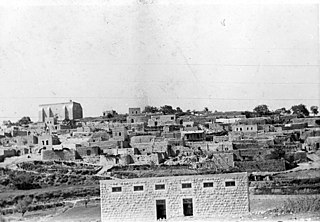
Summil was a Palestinian Arab village in the Gaza Subdistrict, located 36 kilometers (22 mi) northeast of Gaza. It was situated on a sandy hill in the coastal plain and had a population of 950 in 1945. It was depopulated during the 1948 Arab-Israeli War.

<span class="mw-page-title-main">Mughallis</span> Village in Hebron, Mandatory Palestine

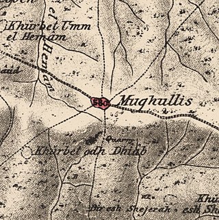
Mughallis was a Palestinian Arab village located 30.5 kilometers (19.0 mi) northwest of Hebron. It was depopulated during the 1948 Arab-Israeli War between July 9–10, 1948 as part of Operation An-Far.

<span class="mw-page-title-main">Dayr Tarif</span> Place in Ramle, Mandatory Palestine

Dayr Tarif was a Palestinian Arab village in the Ramle Subdistrict of Mandatory Palestine. It was depopulated during the 1948 Arab-Israeli War on July 10, 1948.

<span class="mw-page-title-main">Al-Maghar</span> Place in Ramle, Mandatory Palestine

Al-Maghar was a Palestinian Arab village in the Ramle Subdistrict of Mandatory Palestine. It was depopulated by the Givati Brigade during Operation Barak on 18 May 1948. It was located 12 km southwest of Ramla, situated north of Wadi al-Maghar.

<span class="mw-page-title-main">Fara, Safad</span> Village in Safad, Mandatory Palestine

Fara was a Palestinian Arab village in the Safad Subdistrict. It was depopulated during the 1948 Arab-Israeli War on October 30, 1948, under Operation Hiram. It was located 11.5 km north of Safad on the Wadi al-Fara.

<span class="mw-page-title-main">Jahula</span> Place in Safad, Mandatory Palestine

Jahula was a Palestinian Arab village in the Safad Subdistrict. It was depopulated during the 1947–1948 civil war in Mandatory Palestine on May 1, 1948, by the Palmach's First Battalion of Operation Yiftach. It was located 11 km northeast of Safad.

<span class="mw-page-title-main">Qabba'a</span> Village in Safad, Mandatory Palestine

Qabba'a was a Palestinian Arab village in the District of Safad. It was depopulated during the 1948 War on May 26, 1948, by the Palmach's First Battalion of Operation Yiftach. It was located 6 km northeast of Safad.

<span class="mw-page-title-main">Al-'Ulmaniyya</span> Village in Safad, Mandatory Palestine

Al-'Ulmaniyya was a Palestinian Arab village in the Safad Subdistrict. It was depopulated during the 1947–1948 Civil War in Mandatory Palestine on April 20, 1948, by the Palmach's First Battalion of Operation Yiftach. It was located 14.5 km northeast of Safad.

References

  1. Palmer, 1881, p. 267
  2. 1 2 3 Conder and Kitchener, 1882, SWP II, p. 410
  3. 1 2 Morris, 2004, p. xix, village #266. Also gives cause of depopulation.
  4. 1 2 Department of Statistics, 1945, p. 29
  5. 1 2 3 Government of Palestine, Department of Statistics. Village Statistics, April, 1945. Quoted in Hadawi, 1970, p. 66
  6. 1 2 Hütteroth and Abdulfattah, 1977, p.150
  7. 1 2 Khalidi, 1992, p. 385
  8. Barron, 1923, Table VII, Sub-district of Ramleh, p. 21
  9. Mills, 1932, p. 20
  10. Government of Palestine, Department of Statistics. Village Statistics, April, 1945. Quoted in Hadawi, 1970, p. 115
  11. Government of Palestine, Department of Statistics. Village Statistics, April, 1945. Quoted in Hadawi, 1970, p. 165
  12. Givati HQ to General Staff\Operations, 20:50 hours, 16 July 1948, IDFA 922\75\\1176. See also Givati Brigade, "Combat Page", 16 July 1948, IDFA 6127\49\\118. Cited in Morris, 2004, pp. 436–7
  13. Morris, 2004, p.443

Bibliography