Al-Hamma الحمّة El Hamma, El Hammé | |
---|---|
Former railway station of Al-Hamma, with a sign in Arabic reading "al-Hama". [1] | |
Coordinates: 32°41′10″N35°39′51″E / 32.68611°N 35.66417°E | |
Palestine grid | 212/232 |
Geopolitical entity | Mandatory Palestine |
Subdistrict | Tiberias |
Date of depopulation | July 1949 |
Area | |
• Total | 1,692 dunams (1.692 km2 or 418 acres) |
Population (1945) | |
• Total | 290 [4] [5] [6] |
Current Localities | Hamat Gader |
Al-Hamma (Arabic : الحمّة) was a Palestinian Arab village in the Tiberias Subdistrict, 12 kilometres (7.5 mi) southeast of Tiberias. It was situated on a narrow salient in the Yarmouk Valley bounded by Syria to the north and Transjordan to the south and east. Al-Hamma was one of the stations on the Jezreel Valley railway, linking the Hejaz Railway to Haifa. [6] It was depopulated twice, once in July 1949, and again between 1949 and 1956.
The name indicates the presence of hot water springs, as hammah is Arabic for "hot spring". [7] [8]
During the Roman Empire it was known as Emmatha. During this period, Al-Hamma belonged to the district of Gadara. [6]
Recent excavations have revealed a large Umayyad public building comprising several rooms with mosaic floors, set with red, black and white tesserae. The building seems to have been destroyed by the 749 Golan earthquake, but was rebuilt and used until finally abandoned after the earthquake of 1033. [9]
Al-Hamma appeared in Ottoman tax registers compiled in 1596 under the name of Hammat Jur, in the Nahiyas of Gawr, of the Liwa of Ajloun. It was indicated as empty (hali), though taxes were paid on a watermill, in addition to a fixed sum. [10]
In 1875, the French explorer Victor Guérin visited the village. [11]
In 1905, the Jezreel Valley railway opened, linking Haifa via Samakh and Al-Hamma to the Hejaz Railway at Daraa.
In the 1922 census of Palestine, conducted by the British Mandate authorities, Samakh and Al-Hamma were counted together, reaching a total population of 976. Of these, 922 were Muslims, 28 Jews, 1 Baháʼí and 25 Christians; [12] where the Christians were 6 Orthodox, 1 Roman Catholic, 2 Melkite, 11 Armenian and 5 Anglican. [13] At the time of the 1931 census, the village had 46 occupied houses and a population of 170 Muslims, 1 Jew and 1 Christian. [14]
In 1936, a Lebanese businessman, Sulayman Nasif, was given a concession to develop the local springs, which became a popular place to visit, both for local Palestinians and other Arabs. [15] In the 1945 statistics, the village had a population of 290 Muslims, [4] [5] [15] who cultivated a total of 1,105 dunums of land. [2] [15] The villagers were mostly Muslim and Al-Hamma had a large mosque with a fountain in the front courtyard. [15]
During the early part of the 1948 Palestine war, some Palestinian inhabitants of Tiberias fled to Al-Hamma during the unrest in March and April that year. A local leader from Tiberias, Sidqi al Tabari, made "desperate efforts" (according to Israeli sources) to bring the citizens back. The people who had fled to al-Hamma from Tiberias were "ordered back and, in fact, returned". [16]
According to Morris, many villagers in the area had fled or been expelled to Syria during April and early May 1948. However, on 16 May, the villages came under Syrian control and many inhabitants returned. [17] After the war, according to the armistice agreements of 1949 between Israel and Syria, it was determined that a string of villages, including Al-Hamma, Nuqeib, Al-Samra in the Tiberias Subdistrict, as well as Kirad al-Baqqara and Kirad al-Ghannama further north in the Safad Subdistrict, would be included the demilitarized zone (DMZ) between Israel and Syria. The villagers and their property were formally protected by Article V of the Israeli-Syrian agreement of 20 July that year. [17] [18] However, Israel wanted the 2,200 Palestinian inhabitants moved to Syria. [17] The Israeli military thought that the inhabitants of the DMZ remained loyal to Syria and they suspected them of helping Syrian intelligence. Local Jewish settlers and law enforcement suspected the villagers of petty crimes. [19] Morris also notes that Israeli settlers and settlement agencies coveted the land of the local Palestinian Arabs. [20]
Until 1951, Israel had never patrolled or occupied al-Hamma. However, in the spring of that year, Israel decided to assert its claimed sovereignty over the village. [21] On 4 April that year, the IDF General Staff (ignoring protests from the Northern Command) sent two patrol vehicles towards the village. [21] [22] Since Israel was not allowed to have soldiers in the DMZ, the patrol was disguised as policemen. [23] In what became known as the Al-Hamma Incident, seven Israeli soldiers were killed by the Syrians. The following day, four Israeli planes bombed the police station at Al-Hamma and a Syrian position at Al-Hadid. Two women were killed, and six people reported injured. [22] According to Walid Khalidi, Israel then decided to "drive the villagers out", and proceeded to do so during 1949–1956. He described the village site in 1992:
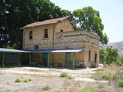
The site has been converted into an Israeli tourist park (Hamat Gader), with parking facilities, swimming pools, and a small fishing pond. The deserted mosque still stands, and its minaret and marble columns are intact. Five buildings east of the village site are built of black basalt. The railroad station still exist and the name of the village is inscribed on its entrance. There are three more deserted buildings next to the station, as well as the remains of destroyed houses. [6] [15]
The area of al-Hamma is mentionned in the article 24 of the Palestinian national covenant in its 1964 version (al-mithaq al-qawmi al-Filastini), together with the West Bank and the Gaza strip.
Danna, was a Palestinian village 13 kilometres north of Baysan that was captured by the Israel Defense Forces during the 1948 Arab-Israeli war, and the villagers were expelled.
Ma'alul was a Palestinian village, with a mixed population of primarily Muslims with a substantial minority of Palestinian Christians, that was depopulated and destroyed by Israel during the 1948 Arab-Israeli war. Located six kilometers west of the city of Nazareth, many of its inhabitants became internally displaced refugees, after taking refuge in Nazareth and the neighbouring town of Yafa an-Naseriyye. Despite having never left the territory that came to form part of Israel, the majority of the villagers of Maalul, and other Palestinian villages like Andor and Al-Mujidal, were declared "absentees", allowing the confiscation of their land under the Absentees Property Law.
Hamat Gader is a hot springs site in the Yarmuk River valley, located in an area under Israeli control, near the Golan Heights and the border with Jordan. It contains a spa, modern and ancient baths, a crocodilians farm and a zoo.
Samakh was a Palestinian Arab village at the south end of Lake Tiberias in Ottoman Galilee and later Mandatory Palestine. It was the site of battle in 1918 during World War I.
Al-Shajara was a Palestinian Arab village depopulated by Israel during the 1948 Arab-Israeli War when its residents were forcefully evacuated and became refugees. It was located 14 kilometers west of Tiberias on the main highway to Nazareth near the villages of Lubya and Hittin. The village was very close to the city of Nazareth, about 5 kilometers away.
Kafr Sabt was a Palestinian Arab village of nearly 500 situated on a sloping plain in the eastern Lower Galilee located 10.5 kilometers (6.5 mi) southwest of Tiberias. It was depopulated in 1948.
Al-Bira, is a depopulated former Palestinian village located 7.5 km north of Baysan. During Operation Gideon, the village was occupied by the Golani Brigade.
Al-Ja'una or Ja'ouna, was a Palestinian village situated in Galilee near al-Houleh Plateau, overlooking the Jordan Valley. The village lay on a hillside 450–500 meters above sea level, 5 kilometers east of Safad near a major road connecting Safad with Tabariya. The village had its Arab residents expelled by Zionist forces in 1948 and was thereafter resettled by Jews, becoming a part of the Israeli settlement of Rosh Pinna.
Arab al-Shamalina also known as Khirbat Abu Zayna was a Palestinian Arab village in the Safad Subdistrict. It was depopulated during the 1947–1948 Civil War in Mandatory Palestine on May 4, 1948, under Operation Matate (Broom), a sub operation of Operation Yiftach. It was located 13 km southeast of Safad near the Jordan River.
Arab al-Zubayd was a Palestinian village in the Safad Subdistrict. It was depopulated during the 1947–1948 Civil War in Mandatory Palestine on April 20, 1948, when the villagers fled on hearing the intentions of The Palmach's First Battalion of Operation Yiftach. It was located 15 km northeast of Safad, near the al-Mutilla-Safad—Tiberias highway.
Jahula was a Palestinian Arab village in the Safad Subdistrict. It was depopulated during the 1947–1948 civil war in Mandatory Palestine on May 1, 1948, by the Palmach's First Battalion of Operation Yiftach. It was located 11 km northeast of Safad.
Kirad al-Ghannama was a Palestinian Arab village in the Safad Subdistrict. It was depopulated during the 1947–1948 Civil War in Mandatory Palestine on April 22, 1948, by the Palmach's First Battalion of Operation Yiftach. It was located 11 km northeast of Safad. Wadi Mushayrifa ran between the two Kirad villages and Wadi Waqqas supplied the village with its water requirements. The village contained the following khirbas: Khirbat Nijmat al-Subh, Tall al-Qadah, and Tall al-Safa.
Kirad al-Baqqara was a Palestinian Arab village in the Safad Subdistrict. It was depopulated during the 1947–1948 Civil War in Mandatory Palestine on April 22, 1948, by the Palmach's First Battalion of Operation Yiftach. It was located 11 km northwest of Safad and Wadi Mushayrifa ran between the two Kirad villages.
Al-Dalhamiyya was a Palestinian Arab village in the Tiberias Subdistrict. It was depopulated during the 1947–1948 Civil War in Mandatory Palestine on April 15, 1948, under Operation Gideon. It was located 14 km south of Tiberias, on the north bank of the Yarmuk River, on the border between Mandatory Palestine and Transjordan.
Khirbat al-Wa'ra al-Sawda' was a Palestinian Arab village in the Tiberias Subdistrict. In 1945, the village had a population of 1,870 Arabs. It was depopulated during the 1947–1948 Civil War in Mandatory Palestine on April 18, 1948. It was located 7.5 km northeast of Tiberias. Some of the villagers fled to Syria while others migrated to the central Galilee.
Al-Nuqayb was a Palestinian Arab village in the Tiberias Subdistrict. It was depopulated during the 1948 Arab-Israeli War on May 15, 1948. It was located 10 km east across the lake from Tiberias. bordering the Wadi al-Muzaffar and Wadi Samakh. al-Nuqayb was named after the Bedouin tribe of 'Arab al-Nuqayb.
Al-Manshiyya was a Palestinian Arab village in the Tiberias Subdistrict, located 11 kilometres south of Tiberias. It was probably depopulated at the same time as neighbouring Al-'Ubaydiyya, in the 1947–1948 Civil War in Mandatory Palestine. Manshiyya was located 1 km south-west of Umm Junieh or Khirbat Umm Juni.
Al-Mansura was a Palestinian Arab village in the Tiberias Subdistrict. It was depopulated during the 1947–1948 Civil War in Mandatory Palestine on May 10, 1948. It was located 16 kilometres northwest of Tiberias.
Al-Samra was a Palestinian Arab village in the Tiberias Subdistrict. It was depopulated on April 21, 1948, during the 1947–1948 Civil War in Mandatory Palestine. It was located 10 km southeast of Tiberias.
The al-Hamma Incident refers to an event on 4 April 1951 that resulted in the death of seven IDF soldiers at the hands of Syrian military forces. The action occurred during an Israeli attempt to enforce its claimed sovereignty over the demilitarized zone along the Syrian border.