
Ma'alul was a Palestinian village, with a mixed population of primarily Muslims with a substantial minority of Palestinian Christians, that was depopulated and destroyed by Israel during the 1948 Arab-Israeli war. Located six kilometers west of the city of Nazareth, many of its inhabitants became internally displaced refugees, after taking refuge in Nazareth and the neighbouring town of Yafa an-Naseriyye. Despite having never left the territory that came to form part of Israel, the majority of the villagers of Maalul, and other Palestinian villages like Andor and Al-Mujidal, were declared "absentees", allowing the confiscation of their land under the Absentees Property Law.

Ammuqa was a Palestinian village, located five kilometres northeast of Safed.

Al-Shajara was a Palestinian Arab village depopulated by Israel during the 1948 Arab-Israeli War when its residents were forcefully evacuated and became refugees. It was located 14 kilometers west of Tiberias on the main highway to Nazareth near the villages of Lubya and Hittin. The village was very close to the city of Nazareth, about 5 kilometers away.

Operation Matateh was a Haganah offensive launched ten days before the end of the British Mandate in Palestine. It was a sub-section of Operation Yiftach, with the objectives of capturing the flatlands between Lake Tiberias and Lake Hula and clear the area of Bedouin encampments. It was carried out by Palmach units under the command of Yigal Allon.

Arab al-Fuqara was a Palestinian Arab village in the Haifa Subdistrict. It was depopulated during the 1947–1948 Civil War in Mandatory Palestine on April 10, 1948. At that time, the land records of the village consisted of a total area of 2,714 dunams, of which 2,513 were owned by Jews, 15 owned by Arabs, and the remaining 186 dunams being public lands.

Al-'Abisiyya was a Palestinian Arab village in the District of Safad. It was depopulated during the 1948 Arab-Israeli War on May 29, 1948, by The Palmach's First Battalion of Operation Yiftach. It was located 28.5 km northeast of Safad near to the Banyas River which the village relied on for irrigation.

Arab al-Shamalina also known as Khirbat Abu Zayna was a Palestinian Arab village in the Safad Subdistrict. It was depopulated during the 1947–1948 Civil War in Mandatory Palestine on May 4, 1948, under Operation Matate (Broom), a sub operation of Operation Yiftach. It was located 13 km southeast of Safad near the Jordan River.

Al-Butayha was a Palestinian Arab village in the Safad Subdistrict. It was depopulated during the 1947–1948 Civil War in Mandatory Palestine on May 4, 1948, by the Palmach's First Battalion during Operation Matateh. It was located 13 km southeast of Safad, quarter of a mile east of the Jordan River, a little northeast of the northern tip of the Sea of Galilee. Many of the inhabitants were forced into Syria.
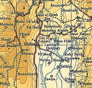
Al-Dawwara was a Palestinian Arab village in the Safad Subdistrict. It was depopulated during the 1948 War on May 25, 1948, by the Palmach's First Battalion of Operation Yiftach. It was located 27 km northeast of Safad, bordering three rivers that flowed into lake al-Hula: the al-Hasbani, Banyas, and Dan rivers.

Al-Dirbashiyya was a Palestinian Arab village in the Safad Subdistrict. It was depopulated during the 1947–1948 Civil War in Mandatory Palestine on May 10, 1948, by the Palmach's First Battalion of Operation Yiftach. It was located 20 km northeast of Safad in the Hula Valley, bordering Hula Lake.

Fara was a Palestinian Arab village in the Safad Subdistrict. It was depopulated during the 1948 Arab-Israeli War on October 30, 1948, under Operation Hiram. It was located 11.5 km north of Safad on the Wadi al-Fara.

Ghabbatiyya was a Palestinian Arab hamlet in the Safad Subdistrict. It was depopulated during the 1948 Arab-Israeli War on October 30, 1948, under Operation Hiram. It was located 12 km northwest of Safad.

Al-Shawka al-Tahta was a Palestinian Arab village in the Safad Subdistrict. It was depopulated during the 1947–1948 Civil War in Mandatory Palestine on May 14, 1948, by the Palmach's First Battalion of Operation Yiftach. It was located 31.5 km northeast of Safad.

Al-Na'ima was a Palestinian Arab village in the Safad Subdistrict of Mandatory Palestine located 26 kilometres (16 mi) northeast of Safad, near the al-Hula Plain. The settlement was depopulated during the 1947-1948 civil war on May 14, 1948 by the Israeli Palmach's First Battalion as part of Operation Yiftach.
Khiyam al-Walid was a Palestinian Arab village in the Safad Subdistrict located 25.5 kilometers (15.8 mi) northeast of Safad along the Syrian border. It was on situated on a hill 150 meters (490 ft) above sea level on the eastern edge of the Hula Valley. In 1945, there were 280 predominantly Muslim inhabitants. It was depopulated during the 1948 Palestine War.

Al-Zahiriyya al-Tahta was a Palestinian Arab village in the Safad Subdistrict. The village was on a descent at the southwestern part of Safad, a town 1 kilometer (0.62 mi) east of the village. Possibly named after the Mamluk sultan al-Zahir Baybars, the village was incorporated into the Safad Sanjak of the Ottoman Empire in 1517, and its entirely Muslim population paid fixed taxes, as well as taxes on winter pastures, an olive oil or grape syrup press and beehives during the 16th century. By the late 19th century, the population grew to 335 inhabitants, all Muslims. The population remained about the same in the last years of British Mandatory rule. The village lands spanned 6,773 dunums, nearly half of which were used to grow grains, the residents living on 28 dunums. Al-Zahiriyya al-Tahta was depopulated during the 1948 Palestine War when its inhabitants fled shortly after the capture of Safed by Jewish paramilitary forces.
Al-Zawiya was a Palestinian Arab village in the Safad Subdistrict. It was depopulated during the 1947–1948 Civil War in Mandatory Palestine on May 24, 1948, by the Palmach's First Battalion of Operation Yiftach. It was located 23 km northeast of Safad.
Al-Zuq al-Fawqani was a Palestinian Arab village in the Safad Subdistrict. It was depopulated during the 1948 Arab-Israeli War on May 21, 1948, by the Palmach's First Battalion of Operation Yiftach. It was located 32 km northeast of Safad.

Al-Nuqayb was a Palestinian Arab village in the Tiberias Subdistrict. It was depopulated during the 1948 Arab-Israeli War on May 15, 1948. It was located 10 km east across the lake from Tiberias. bordering the Wadi al-Muzaffar and Wadi Samakh. al-Nuqayb was named after the Bedouin tribe of 'Arab al-Nuqayb.

Al-Samakiyya was a Palestinian Arab village in the Tiberias Subdistrict. It was depopulated during the 1947–1948 Civil War in Mandatory Palestine on May 4, 1948, under Operation Matateh. It was located 11 km northeast of Tiberias, near the Wadi al-Wadabani. The village was located at Tel Hum, which has been identified with Capernaum.
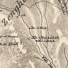 1870s map
  1940s map
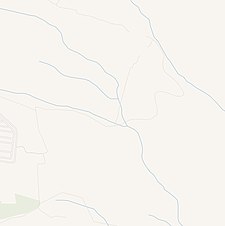 modern map
  1940s with modern overlay map
