History
Some scholars have suggested that the name Tireh reflects the town's history as the original location of Ancient Tyre. [9]
The Crusaders called al-Tira, St. Yohan de Tire, [10] and in the thirteenth century the village contained a Greek Orthodox abbey of St. John the Baptist. [11] [12] In 1283 it was mentioned as part of the domain of the Crusaders, according to the hudna between the Crusaders and the Mamluk sultan Qalawun. [13]
Ottoman era
In 1517 the village was incorporated into the Ottoman Empire with the rest of Palestine. During the 16th and 17th centuries, Tirat al-Lauz belonged to the Turabay Emirate (1517-1683), which encompassed also the Jezreel Valley, Haifa, Jenin, Beit She'an Valley, northern Jabal Nablus, Bilad al-Ruha/Ramot Menashe, and the northern part of the Sharon plain. [14] [15]
In 987 H. (1579 CE) it is recorded that Assaf, the sanjaqbey of al-Lajjun, built a mosque in the village. [16]
In 1596, al-Tira was a village with a population of 52 Muslim households, an estimated 286 persons, under the administrative jurisdiction of the nahiya ("subdistrict") of Shafa, part of Sanjak Lajjun of the Ottoman Empire. Villagers paid a fixed tax-rate of 25% to the authorities for the crops that they cultivated, which included wheat, goats, beehives, and vineyards; a total of 26,000 Akçe. [17] [18]
In 1799, it appeared under the name of El Koneiceh (= Kh. el Keniseh) on the map that Pierre Jacotin compiled that year, though it was misplaced. [19]
Victor Guérin visited in 1870, “I first examined a small mosque, which appears to have been formerly a Christian church. Aligned from west to east it has only a single nave and is terminated towards the east by an apse. One enters through a rectangular door crowned by a fine monolithic lintel. This church, which has been constructed with very regular ashlars, is covered by slightly pointed vaults, above which there is a flat terrace roof.” [20]
After the heavy conscription imposed by the Ottomans in 1872, there was a decline in the village's prosperity, but it subsequently recovered. [21]
A population list from about 1887 showed that Tireh had about 2,555 inhabitants; all Muslims. [22]
Al-Tira had two mosques, named the Old and the New. The Old mosque was originally a church, and was already out of use by 1932. [23] The New mosque appears to be still standing, but now converted into a synagogue. The age of the New Mosque is not agreed upon; Pringle states that it is the mosque built by Assaf in 1579 C.E. However, Petersen, who inspected it in 1994, reports that this is incorrect, and that an inscription set in an arched recess by the door to what was the entrance to the prayer hall records, in provincial nasskhi script, the construction of the mosque to Ishaq ibn Amir in 687 H. (1288-1289 CE). [23]
British Mandate era
In the 1922 census of Palestine, conducted by the British Mandate authorities, Tireh had a population of 2,346; 2,336 Palestinian Muslims, 1 Jew and 9 Christians, [24] where the Christians were 1 Roman Catholic and 8 Orthodox. [25] The population had increased in the 1931 census to 3,191 people; 3,173 Muslims, 17 Christians, 1 Druze, in a total of 624 houses. [26]
In 1943, al-Tira produced more olives and oil than any other village in the Haifa District. The abundance of almond trees in al-Tira gave rise to the village's nickname, Tirat al-Lawz ("Tira of the almonds"). By 1945, its 5,240 Muslims and 30 Christians [3] shared two elementary schools, one for boys, the other for girls. Its economy was based on the cultivation of grain, vegetables and fruit, watered with the natural springs of the village. [18]
By the 1945 statistics, al Tira had a population of 5,270; 30 Christians and 5,240 Muslims, [3] with a total land area of 45,262 dunams. [27] Of this, Palestinians used 16,219 for cereals; 3,543 dunums were irrigated or used for orchards, [28] while a total of 901 dunams were built-up (urban) land. [29]
1948 ethnic cleansing
Shortly after the beginning of the 1948 Palestine war, on 11/12 December 1947 Tira was attacked by the terrorist organisation Irgun and thirteen residents were killed, "mainly children and the elderly" according to historian Ilan Pappé. [30] [31]
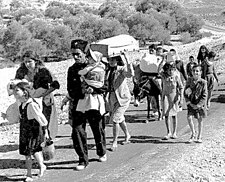
Tira was attacked by the Haganah on the night of 21–22 April 1948, causing some women and children to flee the village. At dawn on April 25, the Haganah mortared Tira, and launched an attack on the village in the early hours of 26 April. An infantry company reached the outskirts of the village but was apparently halted by fire from British units. The village's non-combat population was then evacuated by the British, leaving several hundred armed men to defend it. It fell to Israeli forces in July. [32]
Following the war, the area was incorporated into the State of Israel and absorbed into Tirat Carmel. Tira was first settled with Jewish immigrants in February 1949; by April it had a population of 2,000. [33] Many of Tira's refugees fled to Jordan, mostly to Irbid. [34]
After the war, Palestinian refugees who had been displaced the town established the Wādī al-‘Ein village . The community at Wādī al-‘Ein persisted until the early 1970s, when Israeli authorities forcibly evicted the residents. This eviction was implemented to incorporate the area into the Mount Carmel National Park, which had been designated in 1960. Subsequent to the residents' removal, the dwellings in the small village were not demolished. Instead, they remain vacant up to the present day. [35]
The Palestinian historian Walid Khalidi described the village remains in 1992: "Some of the houses, such as one belonging to 'Irsan al-Dhib, remain standing. The cemetery is unkempt and there are several broken gravestones. The remains of two shrines are visible and the school is used by Israeli students, both Palestinians and Jewish. There are forests and some residential houses in the mountainous part of the surrounding land." [18]
By 2011, four books about the Palestinian village history had been published. [36]
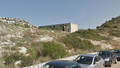
Former Mosque in Al-Tira, presently a synagogue
Old school building in Al-Tira, Haifa
Al-Tira, Haifa, Police station
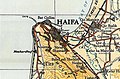
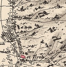 1870s map
  1940s map
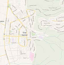 modern map
 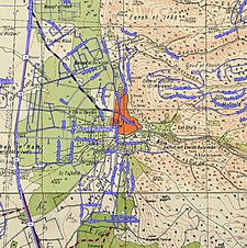 1940s with modern overlay map


