Al-Ras al-Ahmar

Last updated

Contents

Al-Ras al-Ahmar
Etymology: the red head or hill-top [1]
Historical map series for the area of al-Ras al-Ahmar (1870s).jpg 1870s map
Historical map series for the area of al-Ras al-Ahmar (1940s).jpg 1940s map
Historical map series for the area of al-Ras al-Ahmar (modern).jpg modern map
Historical map series for the area of al-Ras al-Ahmar (1940s with modern overlay).jpg 1940s with modern overlay map
A series of historical maps of the area around Al-Ras al-Ahmar (click the buttons)
Mandatory Palestine location map.svg
Red pog.svg
Al-Ras al-Ahmar
Location within Mandatory Palestine
Coordinates: 33°2′21″N35°28′11″E / 33.03917°N 35.46972°E / 33.03917; 35.46972
Palestine grid 194/271
Geopolitical entity Mandatory Palestine
Subdistrict Safad
Date of depopulationOctober 30, 1948 [2]
Area
[3]
  Total
7,934  dunams (7.934 km2 or 3.063 sq mi)
Population
 (1945)
  Total
620 [4] [3]
Cause(s) of depopulationMilitary assault by Yishuv forces
Current Localities Kerem Ben Zimra [5]

Al-Ras al-Ahmar was a Palestinian Arab village in the Safad Subdistrict. It was depopulated during the 1948 Arab–Israeli War on October 30, 1948, by the Israeli 7th Armored Brigade during Operation Hiram. It was located 8.5 km north of Safad.

History

Remains found in the village indicate that it was populated during the Byzantine era. [5]

Ottoman era

Incorporated into the Ottoman Empire in 1517 with the rest of Palestine, in 1596 it appeared under the name of Ras al-Ahmar in the tax registers as part of the nahiya (subdistrict) of Jira in the Safad Sanjak. It had an all Muslim population, consisting of 54 households and 22 bachelors; an estimated 418 persons. They paid taxes on agricultural products, including wheat, barley, vineyards, "kirsanna", goats and beehives, in addition to occasional revenues and an olive oil or grape syrup press; the taxes totalled 5,500 akçe. Half of the revenues went to a Waqf. [5] [6] [7]

In 1838 er-Ras al-Ahmar was noted as a village located in the Safad district. [8] [9]

Algerian followers of Abdelkader El Djezairi have been defeated by the French in Algeria, and sought refuge in another part of the Ottoman Empire. They were settled in various locations in Ottoman Syria, including Al-Ras al-Ahmar. [10]

In 1875 Victor Guérin found that the village was situated 844 meters above sea level, and contained 150 Muslims. [11]

In 1881 the PEF's Survey of Western Palestine described the village "Well-built stone houses. containing 350 Algerian Moslems, situated on high hill, with gardens down the slopes. There is a perennial supply of good water in Wâdy Râs el Ahmar." [12]

A population list from about 1887 showed Ras el Ahmar to have about 690 Muslim inhabitants. [13]

British Mandate era

In the 1922 census of Palestine conducted by the British Mandate authorities, Al-Ras al-Ahmar had a population of 405; all Muslims, [14] increasing slightly in the 1931 census to 447; 6 Christians and 441 Muslims, in a total of 92 houses. [15]

In the 1945 statistics, al-Ras al-Ahmar had a population of 620, all Muslims, [4] and a land area of 7,934 dunams. [3] Of this, 1,008 dunams were plantations and irrigable land, 4,728 were used for cereals, [16] while 61 dunams were classified as built-up, or urban area. [17] An elementary school for boys was founded during this period. [5]

1948, aftermath

Ras al-Ahmar was on the border between the territories allotted to the Arab and to the Jewish state under the 1947 UN Partition Plan. [18]

In March 1948, a British medical officer reported that the village of Al-Ras al-Ahmar was completely unprepared for war. [19]

The fall of Safad and the expulsion of its Arab inhabitants in May 1948, "severely undermined" the morale of surrounding villages, including Al-Ras al-Ahmar, according to Haganah Intelligence sources. They reported that the villagers "had decided to abandon their villages if the Arabs of Safad surrender." [20]

In October 1948 Operation Hiram took place, where the operational orders to the Israeli troop were "to occupy the whole of the Galilee”. On the 30 October 1948, the 71st Battalion from the 7th Armored Brigade took Ras al-Ahmar, together with Rehaniya, Alma and Dayshum. [21] Word of the Jish and Safsaf massacres had apparently spread to Ras al-Ahmar, as the village was largely empty when the 7th Brigade arrived. [22]

By mid-June, 1949, the village lands of Al-Ras al-Ahmar were settled by Jewish immigrants as part of the policy of Judaisation of Northern Israel. [23]

In 1992 it was noted about "Some houses still remain. One house has a front stairway, and a covered garage that apparently was added by the Israelis who live there. Another house has two high, arched windows. The site also contains stone rubble from destroyed houses, and a few fig trees and cactuses. The nearby settlement cultivates some of the surrounding land and uses the rest for grazing." [5]

Related Research Articles

<span class="mw-page-title-main">Mi'ar</span> Palestinian village located 17.5 kilometers east of Acre

Mi'ar, was a Palestinian village located 17.5 kilometers east of Acre. Its population in 1945 was 770. The Crusaders referred to it as "Myary". By the 19th century, during Ottoman rule, it was a large Muslim village. The village was a center of Palestinian Arab rebel operations during the 1936–39 Arab revolt in Palestine against British rule and consequently the village was completely dynamited by the British. Mi'ar was later restored, but it was depopulated by Israeli forces during the 1948 Arab-Israeli War. The Jewish communities of Atzmon, Ya'ad and Manof are located on former village land.

<span class="mw-page-title-main">Dayr al-Qassi</span> Place in Acre, Mandatory Palestine

Dayr al-Qassi or Deir el-Qasi, was a Palestinian Arab village located 26 km northeast of the city of Acre, which was depopulated during 1948 Arab-Israeli war.

<span class="mw-page-title-main">Tarbikha</span> Place in Acre, Mandatory Palestine

Tarbikha, was a Palestinian Arab village. It was located 27 kilometres northeast of Acre in the British Mandate District of Acre that was captured and depopulated by the Israel Defense Forces during the 1948 Arab-Israeli war. The inhabitants of this village were, similar to the inhabitants of Southern Lebanon, Shia Muslims.

Marus was a Palestinian village in Upper Galilee, 7 km northeast of Safad. In the Roman and medieval period it had Jewish population, and by the 16th century it became entirely Muslim. After a period of desertion, the Ottoman authorities resettled it with Algerian Arabs in the 19th century. It was depopulated in 1948 during the Operation Hiram by the Israeli attacking brigade Sheva' Brigade.

<span class="mw-page-title-main">Safsaf</span> Depopulated Palestinian village in present-day Israel

Safsaf was a Palestinian village 9 kilometres northwest of Safed, present-day Israel. Its villagers fled to Lebanon after the Safsaf massacre in October 1948, during the 1948 Arab–Israeli War.

<span class="mw-page-title-main">Al-Malkiyya</span> Place in Safad, Mandatory Palestine

Al-Malkiyya, also known as Al-Malikiyah, was a Palestinian village located in the Jabal Amil region. In a 1920s census, the village was registered as part of Greater Lebanon. It was later placed under the British Mandate of Palestine. Its population was mostly Metawali Shiite.

<span class="mw-page-title-main">Ammuqa</span> Village in Safad, Mandatory Palestine

Ammuqa was a Palestinian village, located five kilometres northeast of Safed.

<span class="mw-page-title-main">Ein al-Zeitun</span> Village in Safad, Mandatory Palestine

Ein al-Zeitun, was a Palestinian Arab village, located 1.5 kilometres (0.93 mi) north of Safed in the Upper Galilee. During the early Ottoman period, Ein el-Zeitun had a mixed population of Muslims and Jews. Later, in the 19th century, it became entirely Muslim. The village's small population and land area as well as its proximity to Safad made it a suburb of the city. In 1945, the village had a population of 820 inhabitants and a total land area of 1,100 dunams. The village was depopulated in 1948, after the Ein al-Zeitun massacre.

<span class="mw-page-title-main">Qaddita</span> Village in Safad, Mandatory Palestine

Qaddita was a Palestinian Arab village of 240, located 4.5 kilometers (2.8 mi) northwest of Safad. It was captured and depopulated in the 1948 Arab-Israeli War, with some of its inhabitants expelled or fleeing to nearby 'Akbara where they live as internally displaced Palestinians and others to refugee camps in Lebanon or Syria.

<span class="mw-page-title-main">Abil al-Qamh</span> Place in Safad, Mandatory Palestine

Abil al-Qamh was a Palestinian village located near the Lebanese border north of Safad. It was depopulated in 1948. It was located at the site of the biblical city of Abel-beth-maachah.

<span class="mw-page-title-main">Al-Ja'una</span> Village in Safad, Mandatory Palestine

Al-Ja'una or Ja'ouna, was a Palestinian village situated in Galilee near al-Houleh Plateau, overlooking the Jordan Valley. The village lay on a hillside 450–500 meters above sea level, 5 kilometers east of Safad near a major road connecting Safad with Tabariya. The village had its Arab residents expelled by Zionist forces in 1948 and was thereafter resettled by Jews, becoming a part of the Israeli settlement of Rosh Pinna.

<span class="mw-page-title-main">Dallata</span> Place in Safad, Mandatory Palestine

Dallata was an Arab village, located on a hilltop 6 kilometers (3.7 mi) north of Safad. Constructed upon an ancient site, it was known to the Crusaders as Deleha. Dallata was included in the late 16th century Ottoman census and British censuses of the 20th century. Its inhabitants were primarily agriculturalists, with some involved in carpentry or trade.

<span class="mw-page-title-main">Fara, Safad</span> Village in Safad, Mandatory Palestine

Fara was a Palestinian Arab village in the Safad Subdistrict. It was depopulated during the 1948 Arab-Israeli War on October 30, 1948, under Operation Hiram. It was located 11.5 km north of Safad on the Wadi al-Fara.

<span class="mw-page-title-main">Fir'im</span> Village in Safad, Mandatory Palestine

Fir'im was a Palestinian Arab village in the Safad Subdistrict that was depopulated during the 1948 Palestine war. It was first attacked during the 1947–1948 Civil War in Mandatory Palestine on May 2, 1948, by the Palmach's First Battalion during Operation Yiftach. In 1945 the population had been 740.

<span class="mw-page-title-main">Jahula</span> Place in Safad, Mandatory Palestine

Jahula was a Palestinian Arab village in the Safad Subdistrict. It was depopulated during the 1947–1948 civil war in Mandatory Palestine on May 1, 1948, by the Palmach's First Battalion of Operation Yiftach. It was located 11 km northeast of Safad.

<span class="mw-page-title-main">Qabba'a</span> Village in Safad, Mandatory Palestine

Qabba'a was a Palestinian Arab village in the District of Safad. It was depopulated during the 1948 War on May 26, 1948, by the Palmach's First Battalion of Operation Yiftach. It was located 6 km northeast of Safad.

<span class="mw-page-title-main">Taytaba</span> Place in Safad, Mandatory Palestine

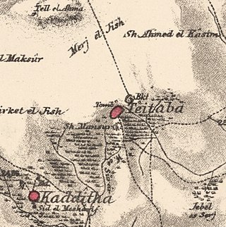
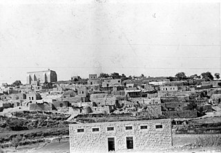
Taytaba was a Palestinian-Arab village in the Safad Subdistrict, located 5 kilometers north of Safad. It was depopulated during the 1947–1948 Civil War in Mandatory Palestine in May 1948 under Operation Hiram. In 1945 it had a population of 530 and a total area of 8,453 dunams, 99.8% of which was Arab-owned.

<span class="mw-page-title-main">Tulayl</span> Place in Safad, Mandatory Palestine

Tulayl was a Palestinian Arab village in the Safad Subdistrict located 14.5 kilometers (9.0 mi) northeast of Safad. It was situated on a hill near Lake Hula. Together with the nearby village of al-Husayniyya, it had a population of 340 in 1945. Tulayl was depopulated during the 1948 Palestine War.

<span class="mw-page-title-main">Al-'Ulmaniyya</span> Village in Safad, Mandatory Palestine

Al-'Ulmaniyya was a Palestinian Arab village in the Safad Subdistrict. It was depopulated during the 1947–1948 Civil War in Mandatory Palestine on April 20, 1948, by the Palmach's First Battalion of Operation Yiftach. It was located 14.5 km northeast of Safad.

<span class="mw-page-title-main">Al-Mansura, Tiberias</span> Village in Tiberias, Mandatory Palestine

Al-Mansura was a Palestinian Arab village in the Tiberias Subdistrict. It was depopulated during the 1947–1948 Civil War in Mandatory Palestine on May 10, 1948. It was located 16 kilometres northwest of Tiberias.

References

  1. Palmer, 1881, p. 92
  2. Morris, 2004, p. xvi, village #39. Also gives cause of depopulation.
  3. 1 2 3 Government of Palestine, Department of Statistics. Village Statistics, April, 1945. Quoted in Hadawi, 1970, p. 71 Archived 2011-06-04 at the Wayback Machine
  4. 1 2 Department of Statistics, 1945, p. 10
  5. 1 2 3 4 5 Khalidi, 1992, p. 488
  6. Hütteroth and Abdulfattah, 1977, p. 175
  7. Note that Rhode, 1979, p. 6 Archived 2019-04-20 at the Wayback Machine writes that the register that Hütteroth and Abdulfattah studied was not from 1595/6, but from 1548/9
  8. Robinson and Smith, vol 3, 2nd appendix, p. 134
  9. Robinson and Smith, vol 3, p. 370
  10. Abbasi, 2007 (Hebrew). Non-Hebrew version in The Maghreb Review, 28(1), 2003, pp. 41-59.
  11. Guérin, 1880, pp. 444-5
  12. Conder and Kitchener, 1881, SWP I, p. 199
  13. Schumacher, 1888, p. 189
  14. Barron, 1923, Table XI, Sub-district of Safad, p. 41
  15. Mills, 1932, p. 109
  16. Government of Palestine, Department of Statistics. Village Statistics, April, 1945. Quoted in Hadawi, 1970, p. 120
  17. Government of Palestine, Department of Statistics. Village Statistics, April, 1945. Quoted in Hadawi, 1970, p. 170
  18. "Map of UN Partition Plan". United Nations. Archived from the original on 24 January 2009. Retrieved 2009-02-09.
  19. Morris, 2004, p. 30
  20. Morris, 2004, p. 226
  21. Morris, 2004, pp. 473-474
  22. Morris, 2004, pp. 482-483
  23. Morris, 2004, pp. 381 -382: By mid-June 1949, [Yehoshua] Eshel wrote, the whole northern border area had been Judaised through the ‘absorption settlements’-moshavim and development towns – such as at Tarshiha, Suhmata, Deir al Qasi, Tarbikha, Meirun, Sammu’i, Safsaf, Ras al Ahmar’.

Bibliography