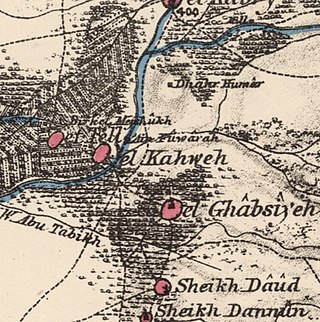
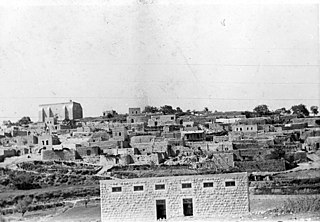
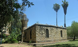
Al-Ghabisiyya was a Palestinian Arab village in northern Palestine, 16 km north-east of Acre in present-day Israel. It was depopulated by the Israel Defense Forces during the 1948 Palestinian expulsion and remains deserted.

Operation Hiram was a military operation conducted by the Israel Defense Forces (IDF) during the 1948 Arab–Israeli War. It was led by General Moshe Carmel, and aimed at capturing the Upper Galilee region from the Arab Liberation Army (ALA) forces led by Fawzi al-Qawuqji and a Syrian battalion. The operation, which lasted 60 hours, ended just before the ceasefire with the neighboring Arab countries went into effect.
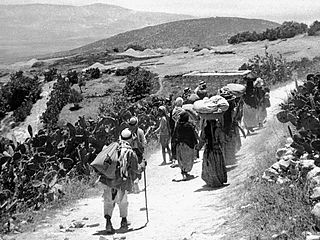
During the 1948 Palestine war, massacres and acts of terror were conducted by and against both sides. A campaign of massacres and violence against the Arab population, such as occurred at Lydda and Ramle and the Battle of Haifa, led to the expulsion and flight of over 700,000 Palestinians, with most of their urban areas being depopulated and destroyed. This violence and dispossession of the Palestinians is known today as the Nakba.
Safsaf was a Palestinian village 9 kilometres northwest of Safed, present-day Israel. Its villagers fled to Lebanon after the Safsaf massacre in October 1948, during the 1948 Arab–Israeli War.

The al-Khisas raid, also known as the al-Khisas massacre, was an attack on the Palestinian village of al-Khisas carried out by the Palmach on December 18, 1947 during the 1948 Palestine war. 10-15 Palestinian villagers were killed in the attack, including 5 children.

Sa'sa' was a Palestinian village, located 12 kilometres northwest of Safed, that was depopulated by Israeli forces during the 1948 Arab-Israeli war. The village suffered two massacres committed by Haganah forces: one in mid-February 1948 and the other at the end of October the same year. Its place has been taken since 1949 by Sasa, an Israeli kibbutz.

The Ein al Zeitun massacre occurred on May 1, 1948, during the 1948 Palestine war, when forces of the Palmach attacked the Palestinian village of Ein al-Zeitun, then part of the British Mandate for Palestine. 70+ villagers were killed in the attack.
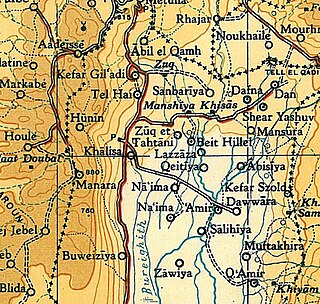
Al-Khalisa was a Palestinian Arab village situated on a low hill on the northwestern edge of the Hula Valley of over 1,800 located 28 kilometers (17 mi) north of Safad. It was depopulated in the 1948 Palestine war.
During the 1948 Palestine war, two massacres were perpetrated by Zionist forces in the Palestinian village of Sa'sa'. The first occurred on the night of 14-15 February 1948, when Palmach forces attacked the village killing approximately 60 people. The second massacre occurred on 30 October 1948 when the village was conquered by the Israeli military as part of Operation Hiram.
Qumya, was a Palestinian village of 510 inhabitants when it was depopulated prior to the 1948 Arab-Israeli war.

Salamah was a Palestinian Arab village, located five kilometers east of Jaffa, that was depopulated in the lead-up to the 1948 Arab-Israeli War. The town contains the supposed grave of Salama Abu Hashim, a companion of the Islamic prophet Muhammad. His tomb, two village schools, and ten houses from among the over 800 houses that had made up the village, are all that remain of the structures of the former village today.

Jubb Yusuf, also called 'Arab al-Suyyad, was a Palestinian village depopulated in the 1948 Arab–Israeli War.

Al-Rihaniyya was a Palestinian Arab village in the Haifa Subdistrict. It was depopulated during the 1947–1948 Civil War in Mandatory Palestine on 30 April 1948 as part of the battle of Mishmar HaEmek. It was located 25 km southeast of Haifa and 3 km northwest of Wadi al-Mileh.
Arab al-Zubayd was a Palestinian village in the Safad Subdistrict. It was depopulated during the 1947–1948 Civil War in Mandatory Palestine on April 20, 1948, when the villagers fled on hearing the intentions of The Palmach's First Battalion of Operation Yiftach. It was located 15 km northeast of Safad, near the al-Mutilla-Safad—Tiberias highway.

Al-Butayha was a Palestinian Arab village in the Safad Subdistrict. It was depopulated during the 1947–1948 Civil War in Mandatory Palestine on May 4, 1948, by the Palmach's First Battalion during Operation Matateh. It was located 13 km southeast of Safad, quarter of a mile east of the Jordan River, a little northeast of the northern tip of the Sea of Galilee. Many of the inhabitants were forced into Syria.
Al-Dawwara was a Palestinian Arab village in the Safad Subdistrict. It was depopulated during the 1948 War on May 25, 1948, by the Palmach's First Battalion of Operation Yiftach. It was located 27 km northeast of Safad, bordering three rivers that flowed into lake al-Hula: the al-Hasbani, Banyas, and Dan rivers.

Jahula was a Palestinian Arab village in the Safad Subdistrict. It was depopulated during the 1947–1948 civil war in Mandatory Palestine on May 1, 1948, by the Palmach's First Battalion of Operation Yiftach. It was located 11 km northeast of Safad.

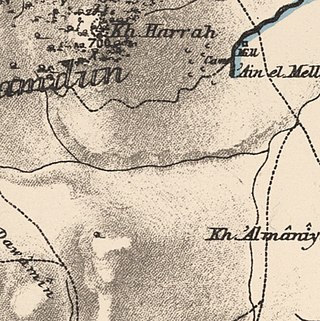
Kirad al-Ghannama was a Palestinian Arab village in the Safad Subdistrict. It was depopulated during the 1947–1948 Civil War in Mandatory Palestine on April 22, 1948, by the Palmach's First Battalion of Operation Yiftach. It was located 11 km northeast of Safad. Wadi Mushayrifa ran between the two Kirad villages and Wadi Waqqas supplied the village with its water requirements. The village contained the following khirbas: Khirbat Nijmat al-Subh, Tall al-Qadah, and Tall al-Safa.
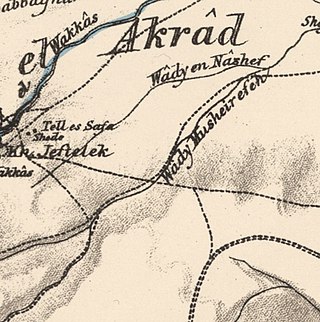
Kirad al-Baqqara was a Palestinian Arab village in the Safad Subdistrict. It was depopulated during the 1947–1948 Civil War in Mandatory Palestine on April 22, 1948, by the Palmach's First Battalion of Operation Yiftach. It was located 11 km northwest of Safad and Wadi Mushayrifa ran between the two Kirad villages.

Al-Nuqayb was a Palestinian Arab village in the Tiberias Subdistrict. It was depopulated during the 1948 Arab-Israeli War on May 15, 1948. It was located 10 km east across the lake from Tiberias. bordering the Wadi al-Muzaffar and Wadi Samakh. al-Nuqayb was named after the Bedouin tribe of 'Arab al-Nuqayb.


