Al-Sawafir al-Shamaliyya

Last updated

Contents

al-Sawafir al-Shamaliyya
السوافير الشمالية
al-Sawafir al-Halil, Suafir Ibn Audeh, [1]
Saouafir ech-Chemalieh Saouafir, [2] Abou -A'ouarr, [2]
Sawalir Shamali, [3] Sawafir esh Shamaliya,
[4] sawafir ode [5]
Etymology: "The northern nomads" [1]
Historical map series for the area of al-Sawafir al-Shamaliyya (1870s).jpg 1870s map
Historical map series for the area of al-Sawafir al-Shamaliyya (1940s).jpg 1940s map
Historical map series for the area of al-Sawafir al-Shamaliyya (modern).jpg modern map
Historical map series for the area of al-Sawafir al-Shamaliyya (1940s with modern overlay).jpg 1940s with modern overlay map
A series of historical maps of the area around Al-Sawafir al-Shamaliyya (click the buttons)
Mandatory Palestine location map.svg
Red pog.svg
al-Sawafir al-Shamaliyya
Location within Mandatory Palestine
Coordinates: 31°42′48″N34°42′15″E / 31.71333°N 34.70417°E / 31.71333; 34.70417
Palestine grid 122/124
Geopolitical entity Mandatory Palestine
Subdistrict Gaza
Date of depopulationMay 18, 1948 [6]
Area
[7]
  Total
5,861  dunams (5.861 km2 or 2.263 sq mi)
Population
 (1945)
  Total
680 [8] [7]
Cause(s) of depopulationFear of being caught up in the fighting

Al-Sawafir al-Shamaliyya (Arabic : السوافير الشمالية) was a Palestinian Arab village in the Gaza Subdistrict, located 33 kilometers (21 mi) northeast of Gaza situated along the southern coastal plain of Palestine 50 meters (160 ft) above sea level. It was one of three namesake villages, alongside Al-Sawafir al-Sharqiyya and Al-Sawafir al-Gharbiyya.

It had a population of 680 in 1945. Al-Sawafir al-Shamaliyya was depopulated in the 1948 Arab-Israeli War. [9]

History

The village was possibly located at the site of the biblical Shafir, mentioned by Eusibius as a "beautiful town" between Ascalon and Bayt Jibrin. Most modern scholars, however, located Shafir at Khirbat al-Qawm. The Crusader name of the village was Zeophir. They recorded that it was the property of Bishop of Jerusalem in the early 12th century. [9] However, it is not clear which village of three Sawafirs these records pertain to. [10]

Ottoman era

Incorporated into the Ottoman Empire in 1517 with the rest of Palestine, Al-Sawafir al-Shamaliya appears in the 1596 tax records as Sawafir al-Halil. It was under the administration of the nahiya of Gaza, part of the Liwa of Gaza. The village contained 112 households, 71 were Muslim and 41 Christians. [11] [12] With a total population of an estimated 616, the villagers paid a fixed tax-rate of 33,3 % on agricultural products, including wheat, barley, olive and fruit trees; a total of 19,550 akçe. All of the revenues went to a waqf. [13]

In 1838 the three Sawafir villages were noted located in the Gaza district. The western village (=Al-Sawafir al-Gharbiyya) was noted as "in ruins or deserted", while the two others were noted as being Muslim. [14] [15]

In 1863, French explorer Victor Guérin visited the village, which he estimated had five hundred inhabitants. He found three barrels of broken ancient columns of gray-white marble near a well. A koubbeh there was dedicated to a Sheikh Sidi Abd-Allah. [2]

An Ottoman village list of about 1870 found 55 houses and a population of 171, though the population count included men only. [5]

In 1882 the PEF's Survey of Western Palestine (SWP) found that al-Sawafir al-Shamaliyya had several small gardens and wells. [16]

British Mandate era

In the 1922 census of Palestine conducted by the British Mandate authorities, the village had a population of 334 inhabitants, consisting of 333 Muslims and 1 Christian, [3] increasing in the 1931 census to an all-Muslim population of 454 in 77 houses. [4]

In the 1945 statistics the population of Sawafir esh Shamaliya was 680 Muslims, [8] while the total land area was 5,861 dunams, according to an official land and population survey. [7] Of this, a total of 670 dunams were used citrus and bananas, 10 were for plantations and irrigable land, 4,894 for cereals, [17] while 21 dunams were built-up areas. [18]

Many of its houses were built of adobe, although few were made of stone. The residents were Muslim, and the village had its own mosque, but shared a school with the neighboring villages of al-Sawafir al-Gharbiyya and al-Sawafir al-Sharqiyya. The number of students in the school was 280 in the mid-1940s. Agriculture was the mainstay of the economy, and grain, citrus, grapes, and apricots were grown. [9]

Al-Sawafir al-Shamaliyya 1930 1:20,000 Al-Sawafir.jpg
Al-Sawafir al-Shamaliyya 1930 1:20,000
Sawafir 1945 1:250,000 Sawafir 1945.jpg
Sawafir 1945 1:250,000

1948 War and aftermath

In early May, 1948, the inhabitants of the three Al-Sawafir villages were ordered not to flee, by the Al-Majdal National Committee. [19]

Al-Sawafir al-Shamaliyya was captured by the Haganah in Operation Barak on May 12. [20] Its residents may have been pushed out by the attack on Bayt Daras on May 10 which was preceded by a mortar attack, but it's more likely that the village was depopulated on the attack of the village itself, according to an Associated Press dispatch which quoted a Haganah source. [9] At the 23 May, 1948, Israeli reports say that at all the three Al-Sawafir villages the inhabitants slept in the fields at night, but returned to work in the villages by day. [21]

At the near end of the 1948 Arab-Israeli War, Egyptian and Sudanese forces planned to recapture al-Sawafir al-Shamaliyya, but were prevented from doing so at an early stage. [9]

Following the war the area was incorporated into the State of Israel, but the land was left undeveloped. According to Palestinian historian, Walid Khalidi, "A few vacant houses and segments of houses, standing amidst wild vegetation, mark the site. One of them has a covered porch supported on two columns. An old village road is also identifiable, and cactuses and fig trees grow on the site." [9]

See also

Related Research Articles

<span class="mw-page-title-main">Nimrin</span> Place in Tiberias, Mandatory Palestine

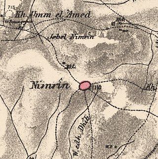
Nimrin was a Palestinian Arab town of 320 that was captured and depopulated by Israel during the 1948 Arab-Israeli War.

<span class="mw-page-title-main">Iraq Suwaydan</span> Place in Gaza, Mandatory Palestine

'Iraq Suwaydan was a Palestinian Arab village located 27 km (17 mi) northeast of Gaza City. It was captured by Israeli forces in Operation Yoav against the defending Egyptian Army during the 1948 Arab-Israeli War. The village infrastructure, with the exception of the police station built by the British Mandate authorities, was destroyed.

<span class="mw-page-title-main">Bayt Jirja</span> Place in Gaza, Mandatory Palestine

Bayt Jirja or Beit Jerja was a Palestinian Arab village 15.5 km Northeast of Gaza. In 1931 the village consisted of 115 houses. It was overrun by Israeli forces during operation Yo'av in the 1948 Arab-Israeli war. Bayt Jirja was found depopulated in November 1948, during "clean up sweeps" to expel any partial inhabited villages and destroy village housing to prevent any possible re-occupation in the area. The village was completely destroyed after the occupation and only one tomb remains.

<span class="mw-page-title-main">Islin</span> Place in Jerusalem, Mandatory Palestine

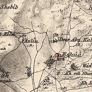
Islin was a Palestinian Arab village located 21 kilometers west of Jerusalem. The village had a population of 302 inhabitants and was depopulated during the 1948 Arab-Israeli war. It was occupied by Israeli forces, possibly from the Fourth Battalion of the Harel Brigade, on 18 July 1948 during Operation Dani, causing its inhabitants to leave. Eshtaol, a moshav, was built on the village's land.

<span class="mw-page-title-main">Idnibba</span> Place in Ramle, Mandatory Palestine

Idnibba was a Palestinian village, located at latitude 31.7426937N and longitude 34.8561001,E in the southern part of the Ramle Subdistrict. It was depopulated in 1948, at which time its population was 568, and its lands are now used by Kfar Menahem.

<span class="mw-page-title-main">Najd, Gaza</span> Place in Gaza, Mandatory Palestine

Najd was a Palestinian Arab village, located 14 kilometers (8.7 mi) northeast of Gaza City. During the British Mandate in Palestine, children from Najd attended school in the nearby village of Simsim. On 13 May 1948, Najd was occupied by the Negev Brigade as part of Operation Barak, and the villagers were expelled.

<span class="mw-page-title-main">Al-Muharraqa</span> Place in Gaza, Mandatory Palestine

Al-Muharraqa was a Palestinian Arab village in the Gaza Subdistrict, located 14.5 kilometers (9.0 mi) east of Gaza city. The village laid on rolling terrain on the southern coastal plain of Palestine, on a bend in the wadi. It had an elevation of 125 meters (410 ft) and a total land area of 4,855 dunams, most of which was public property, while its built-up area of 29 dunams was Arab-owned. Al-Muharraqa was depopulated during the 1948 Arab-Israeli War.

<span class="mw-page-title-main">Ibdis</span> Place in Gaza, Mandatory Palestine

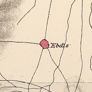
'Ibdis was a Palestinian village in the Gaza Subdistrict, located 30 kilometers (19 mi) northeast of Gaza City. It was situated on flat ground on the coastal plain at an elevation of 75 meters (246 ft) above sea level, and bordered by a wadi that bore its name on its eastern side. In 1945, Ibdis had a population of 540 and a land area of 4,593 dunams, of which 18 dunams were built-up areas.

<span class="mw-page-title-main">Dayr Sunayd</span> Place in Gaza, Mandatory Palestine

Dayr Sunayd was a Palestinian Arab village in the Gaza Subdistrict, located 12 kilometers (7.5 mi) northeast of Gaza. Situated at an elevation of 50 meters (160 ft) along the southern coastal plain of Palestine, Deir Sunayd had a total land area of 6,081 dunams. Prior to its depopulation during the 1948 Arab–Israeli War, it had 730 inhabitants in 1945.

<span class="mw-page-title-main">Al-Batani al-Sharqi</span> Place in Gaza, Mandatory Palestine

Al-Batani al-Sharqi was a Palestinian Arab village in the Gaza Subdistrict, located 36.5 kilometers (22.7 mi) northeast of Gaza situated in the flat terrain on the southern coastal plain of Palestine. It had a population of 650 in 1945. Al-Batani al-Sharqi was depopulated during the 1948 Arab-Israeli War.

<span class="mw-page-title-main">Jusayr</span> Place in Gaza, Mandatory Palestine

Jusayr was a Palestinian Arab village in the Gaza Subdistrict. It was depopulated during the 1948 Arab-Israeli War on July 17, 1948, under Operation Barak or Operation Yo'av. It was located 35 km northeast of Gaza.

<span class="mw-page-title-main">Al-Sawafir al-Sharqiyya</span> Place in Gaza, Mandatory Palestine

Al-Sawafir al-Sharqiyya was a Palestinian Arab village in the Gaza Subdistrict. It was depopulated during the 1948 War on May 18, 1948, as part of the second stage of Operation Barak. The village was located 32 km northeast of Gaza. It is one of three namesake villages, alongside Al-Sawafir al-Gharbiyya and Al-Sawafir al-Shamaliyya.

<span class="mw-page-title-main">Al-Sawafir al-Gharbiyya</span> Place in Gaza, Mandatory Palestine

Al-Sawafir al-Gharbiyya was a Palestinian Arab village in the Gaza Subdistrict. It was depopulated during the 1948 War on May 18, 1948, during the second stage of Operation Barak. It was located 30 km northeast of Gaza city. It was one of three namesake villages, alongside Al-Sawafir al-Sharqiyya and Al-Sawafir al-Shamaliyya.

<span class="mw-page-title-main">Mughallis</span> Village in Hebron, Mandatory Palestine

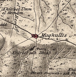
Mughallis was a Palestinian Arab village located 30.5 kilometers (19.0 mi) northwest of Hebron. It was depopulated during the 1948 Arab-Israeli War between July 9–10, 1948 as part of Operation An-Far.

<span class="mw-page-title-main">Al-Jammasin al-Gharbi</span> Village in Jaffa, Mandatory Palestine

Al-Jammasin al-Gharbi was a Palestinian Arab village in the Jaffa Subdistrict. It was depopulated during the 1947–48 Civil War in Mandatory Palestine on March 17, 1948. It was located 6.5 km northeast of Jaffa.

<span class="mw-page-title-main">Al-Jammasin al-Sharqi</span> Village in Jaffa, Mandatory Palestine

Al-Jammasin al-Sharqi was a Palestinian Arab village in the Jaffa Subdistrict. It was depopulated during the 1948 Palestine War on March 17, 1948. It was located 9 km northeast of Jaffa.

<span class="mw-page-title-main">Al-Maghar</span> Place in Ramle, Mandatory Palestine

Al-Maghar was a Palestinian Arab village in the Ramle Subdistrict of Mandatory Palestine. It was depopulated by the Givati Brigade during Operation Barak on 18 May 1948. It was located 12 km southwest of Ramla, situated north of Wadi al-Maghar.

<span class="mw-page-title-main">Al-Tina</span> Place in Ramle, Mandatory Palestine

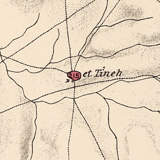
Al-Tina, or Khirbet et-Tineh was a Palestinian Arab village in the Ramle Subdistrict of Mandatory Palestine. The village was located between the Shfela and southern Israeli coastal plain. It was depopulated during the 1948 Arab–Israeli War on July 8, 1948, by the Givati Brigade under Operation An-Far. It was located 20. km south of Ramla. The hill on which the village was built stands today next to the Kiryat Mal'akhi – Yoav railway station and next to Highway 6. Archeological excavations at the site revealed the remains of a Byzantine settlement.

<span class="mw-page-title-main">Al-'Ulmaniyya</span> Village in Safad, Mandatory Palestine

Al-'Ulmaniyya was a Palestinian Arab village in the Safad Subdistrict. It was depopulated during the 1947–1948 Civil War in Mandatory Palestine on April 20, 1948, by the Palmach's First Battalion of Operation Yiftach. It was located 14.5 km northeast of Safad.

<span class="mw-page-title-main">Hadatha</span> Place in Tiberias, Mandatory Palestine

Hadatha, also El Hadetheh or Hadateh, was a Palestinian Arab village in the District of Tiberias, located 12.5 km southwest of Tiberias. It was depopulated in the 1947–1948 civil war in Mandatory Palestine.

References

  1. 1 2 Also called Suafir Ibn Audeh, the nomads of Ibn Audeh (personal name); but this is said to be a modern name, from an inhabitant who died within the century, according to Palmer, 1881, p. 274
  2. 1 2 3 Guérin, 1869, p. 82
  3. 1 2 Barron, 1923, Table V, Sub-district of Gaza, p.8
  4. 1 2 Mills, 1932, p. 6
  5. 1 2 Socin, 1879, p. 160
  6. Morris, 2004, p. xix, village #283. Also gives the cause for depopulation.
  7. 1 2 3 Government of Palestine, Department of Statistics. Village Statistics, April, 1945. Quoted in Hadawi, 1970, p. 46
  8. 1 2 Department of Statistics, 1945, p. 32
  9. 1 2 3 4 5 6 Khalidi, 1992, pp. 133-134.
  10. Marom, Roy; Taxel, Itamar (2023-10-01). "Ḥamāma: The historical geography of settlement continuity and change in Majdal 'Asqalan's hinterland, 1270–1750 CE". Journal of Historical Geography. 82: 49–65. doi: 10.1016/j.jhg.2023.08.003 . ISSN   0305-7488.
  11. Petersen, 2005, p. 131. See note on Talk:Al-Sawafir al-Shamaliyya
  12. Hütteroth and Abdulfattah, 1977, p. 151
  13. Hütteroth and Abdulfattah, 1977, p. 151, estimate in Khalidi, 1992, p. 134
  14. Robinson and Smith, 1841, vol 3, Appendix 2, p. 118
  15. Robinson and Smith, 1841, vol 2, p. 370
  16. Conder and Kitchener, 1882, SWP II, p. 413. Quoted in Khalidi, 1992, 134
  17. Government of Palestine, Department of Statistics. Village Statistics, April, 1945. Quoted in Hadawi, 1970, p. 88
  18. Government of Palestine, Department of Statistics. Village Statistics, April, 1945. Quoted in Hadawi, 1970, p. 138
  19. Morris, 2004, p. 179
  20. Morris, 2004, p. 256
  21. Morris, 2004, pp. 257-258

Bibliography