
'Iraq Suwaydan was a Palestinian Arab village located 27 km (17 mi) northeast of Gaza City. It was captured by Israeli forces in Operation Yoav against the defending Egyptian Army during the 1948 Arab-Israeli War. The village infrastructure, with the exception of the police station built by the British Mandate authorities, was destroyed.

Bayt Nabala or Beit Nabala was a Palestinian Arab village in the Ramle Subdistrict in Palestine that was destroyed during the 1948 Arab–Israeli War. The village was in the territory allotted to the Arab state under the 1947 UN Partition Plan, which was rejected by Arab leaders and never implemented. Its population in 1945, before the war, was 2,310.
Bayt Jirja or Beit Jerja was a Palestinian Arab village 15.5 km Northeast of Gaza. In 1931 the village consisted of 115 houses. It was overrun by Israeli forces during operation Yo'av in the 1948 Arab-Israeli war. Bayt Jirja was found depopulated in November 1948, during "clean up sweeps" to expel any partial inhabited villages and destroy village housing to prevent any possible re-occupation in the area. The village was completely destroyed after the occupation and only one tomb remains.

Bayt Daras was a Palestinian Arab town located 46 kilometers (29 mi) northeast of Gaza and approximately 50 meters (160 ft) above sea level. The village was depopulated and destroyed during the 1948 Palestine war, as part of the 1948 Palestinian expulsion and the Nakba.

Yasur was a Palestinian village, located 40 kilometres northeast of Gaza, that was depopulated during the 1948 Arab–Israeli War. Its inhabitants fled a military assault by the First Battalion of Israel's Givati Brigade on 9 June 1948, part of Operation Barak.

Idnibba was a Palestinian village, located at latitude 31.7426937N and longitude 34.8561001,E in the southern part of the Ramle Subdistrict. It was depopulated in 1948, at which time its population was 568, and its lands are now used by Kfar Menahem.
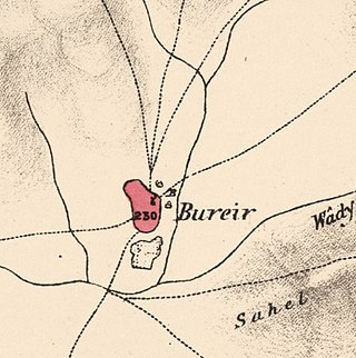
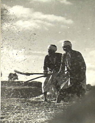
Burayr was a Palestinian Arab village in the Gaza Subdistrict, 18 kilometers (11 mi) northeast of Gaza City. Its population in 1945 was 2,740 and it was depopulated during the 1948 Palestine war as part of the 1948 Palestinian expulsion and flight. It had an average elevation of 100 meters (330 ft).
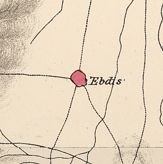
'Ibdis was a Palestinian village in the Gaza Subdistrict, located 30 kilometers (19 mi) northeast of Gaza City. It was situated on flat ground on the coastal plain at an elevation of 75 meters (246 ft) above sea level, and bordered by a wadi that bore its name on its eastern side. In 1945, Ibdis had a population of 540 and a land area of 4,593 dunams, of which 18 dunams were built-up areas.

Al-Sawafir al-Shamaliyya was a Palestinian Arab village in the Gaza Subdistrict, located 33 kilometers (21 mi) northeast of Gaza situated along the southern coastal plain of Palestine 50 meters (160 ft) above sea level. It was one of three namesake villages, alongside Al-Sawafir al-Sharqiyya and Al-Sawafir al-Gharbiyya.

Al-Batani al-Gharbi was a Palestinian village in the Gaza Subdistrict. It was depopulated during the 1947–48 Civil War in Mandatory Palestine on May 13, 1948, by the Giv'ati Brigade under Operation Barak. It was located 36 km (22 mi) northeast of Gaza.
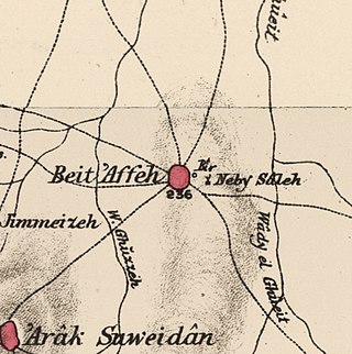
Bayt 'Affa was a Palestinian village in the Gaza Subdistrict. It was depopulated and destroyed during the 1947–48 Civil War in Mandatory Palestine. It was located 29 km (18 mi) northeast of Gaza and Wadi al-Rana ran east of the village.
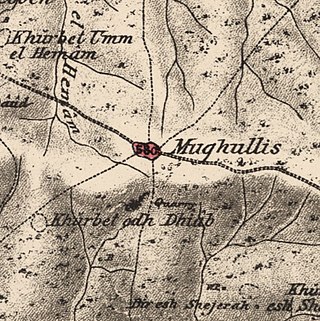
Mughallis was a Palestinian Arab village located 30.5 kilometers (19.0 mi) northwest of Hebron. It was depopulated during the 1948 Arab-Israeli War between July 9–10, 1948 as part of Operation An-Far.

Zayta was a Palestinian Arab village in the Hebron Subdistrict in Mandate Palestine. During Crusader rule in Palestine, the village is mentioned as forming part of the landholdings of the Order of St. John. At the time of the rule of the Ottoman Empire, according to the 1596 census, Zayta had a population of 165. Mentioned by Western travellers to the region in the 19th century, it is described by one as, "a picturesque Arab village"; by 1945, its population was 330 inhabitants.

Al-Jammasin al-Gharbi was a Palestinian Arab village in the Jaffa Subdistrict. It was depopulated during the 1947–48 Civil War in Mandatory Palestine on March 17, 1948. It was located 6.5 km northeast of Jaffa.
Al-Jammasin al-Sharqi was a Palestinian Arab village in the Jaffa Subdistrict. It was depopulated during the 1948 Palestine War on March 17, 1948. It was located 9 km northeast of Jaffa.

Al-Safiriyya was a Palestinian Arab village in the Jaffa Subdistrict. It was depopulated during Operation Hametz in the 1948 Palestine War on May 20, 1948. It was located 11 km east of Jaffa, 1.5 km west of Ben Gurion Airport.
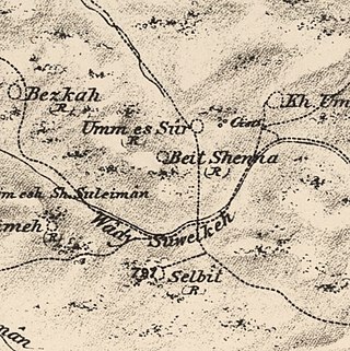
Bayt Shanna was a Palestinian Arab village in the Ramle Subdistrict of Mandatory Palestine. It was depopulated during the 1948 Arab–Israeli War on July 15, 1948, during the second stage of Operation Dani. It was located 11.5 km southeast of Ramla.

Bayt Susin was a Palestinian Arab village in the Ramle Subdistrict of Mandatory Palestine, located 17 kilometers (11 mi) southeast of Ramla. In 1945, it had 210 inhabitants. The village was depopulated during the 1948 war by the Israeli 7th Brigade.

Dayr Tarif was a Palestinian Arab village in the Ramle Subdistrict of Mandatory Palestine. It was depopulated during the 1948 Arab-Israeli War on July 10, 1948.

Zikrin, pronounced Dhikrin, was a Palestinian Arab village in the Hebron Subdistrict, depopulated in the 1948 Palestine War. The site is located about 6 kilometres (3.7 mi) northwest of Beit Gubrin and sits at a mean elevation of 212 metres (696 ft) above sea-level, its access somewhat impeded by hedges of buckthorn and cactus. The entire site is dotted with grottoes and caves, and razed structures.
 1870s map
  1940s map
 modern map
  1940s with modern overlay map

