Al-Zahiriyya al-Tahta

Last updated

Contents

Al-Zahiriyya al-Tahta
الظاهرية التحته
Dhahiriya Tahta [1]
Edh Dhaheriyeh et Tahta [2]
Ruin with a view - panoramio.jpg
Maqam for Sheikh el-Kuweiyis ("the pretty sheikh") in 2010, located south-southwest of the village site [5] [6]
19-26-Safad-1942 (Edh Dhahriya et Tahta land area).jpg
The village boundary of Al-Zahiriyya al-Tahta on the 1942 Survey of Palestine map; click image to view full map. The village maqam is shown as "Esh Sh. Kuweiyis", southwest of the built up area of Edh Dhahiriya et Tatha but within the village land borders.
Mandatory Palestine location map.svg
Red pog.svg
Al-Zahiriyya al-Tahta
Location within Mandatory Palestine
Coordinates: 32°57′47″N35°29′12″E / 32.96306°N 35.48667°E / 32.96306; 35.48667
Palestine grid 195/263
Geopolitical entity Mandatory Palestine
Subdistrict Safad
Depopulation 10 May 1948 [1]
Area
  Total
6,773  dunams (6.773 km2 or 2.615 sq mi)
Population
 (1945)
  Total
350 [7] [8]
Cause(s) of depopulationInfluence of nearby town's fall
Current Localities Safad [9]

Al-Zahiriyya al-Tahta (Arabic : الظاهرية التحته, romanized: al-Ẓāhiriyya al-Ṭaḥṭā) was a Palestinian Arab village in the Safad Subdistrict. The village was on a descent at the southwestern part of Safad, [10] a town 1 kilometer (0.62 mi) east of the village. Possibly named after the Mamluk sultan al-Zahir Baybars (r.1260–1277), the village was incorporated into the Safad Sanjak of the Ottoman Empire in 1517, and its entirely Muslim population paid fixed taxes, as well as taxes on winter pastures, an olive oil or grape syrup press and beehives during the 16th century. By the late 19th century, the population grew to 335 inhabitants, all Muslims. The population remained about the same in the last years of British Mandatory rule. The village lands spanned 6,773 dunums, nearly half of which were used to grow grains, the residents living on 28 dunums. Al-Zahiriyya al-Tahta was depopulated during the 1948 Palestine War when its inhabitants fled shortly after the capture of Safed by Jewish paramilitary forces.

Name

According to Edward Henry Palmer the name Edh Dhaheriyeh et Tahta means "The lower village on the ridge", [2] while according to Walid Khalidi, the name Zahiriyya might be a tribute to the Mamluk Sultan al-Zahir Baybars. [10]

History

Ottoman era

Incorporated into the Ottoman Empire in 1517 with the rest of Palestine; in the 1596 tax registers al-Zahiriyya al-Tahta belonged to the nahiya (subdistrict) of Jira in the Safad Sanjak. It had an all Muslim population, consisting of 56 households; an estimated population of 308. The villagers paid most of its taxes as a fixed sum of 6,000 akçe. In addition they paid taxes on goats and beehives, winter pastures, occasional revenues, and a press for olive oil or grape syrup; a total 6,336 akçe. Part of the revenues went to a waqf (religious endowment). [10] [11] [12]

The village appeared under the name of Elzalarieh on the map that Pierre Jacotin compiled during Napoleon's invasion of 1799, [13] while in 1838 it was noted as a village in the Safad district. [14] In 1881 the PEF's Survey of Western Palestine described al-Zahiriyya al-Tahta: "This village is built of good stone materials, at the foot of a hill, with olives and arable land around. It is inhabited by about 100 Moslems, and has two good springs close to the village." [15] A population list from about 1887 referred to the village as Kiryet ed Daheriyeh, and counted 335 Muslim inhabitants. [16]

British Mandate era

Historical map series for the area of al-Zahiriyya al-Tahta (1870s).jpg 1870s map
Historical map series for the area of al-Zahiriyya al-Tahta (1940s).jpg 1940s map
Historical map series for the area of al-Zahiriyya al-Tahta (modern).jpg modern map
Historical map series for the area of al-Zahiriyya al-Tahta (1940s with modern overlay).jpg 1940s with modern overlay map
A series of historical maps of the area around Al-Zahiriyya al-Tahta (click the buttons)

In the 1922 census of Palestine conducted by the British Mandate authorities, al-Zahiriyya al-Tahta had a population of 212 Muslims, [17] increasing slightly in the 1931 census to 256 Muslims, in a total of 53 houses. [18] In the 1945 statistics, al-Zahiriyya al-Tahta had a population of 350, all Muslims, [7] and a land area of 6,773 dunams. [8] Of this, 810 dunams were plantations and irrigable land, 3,042 were used for grain, [19] while 28 dunams were classified as built-up, or urban area. [20] The children in the village went to school in Safad. [10]

1948 war and aftermath

The inhabitants of al-Zahiriyya al-Tahta fled the village in the aftermath of Safed's capture by the Jewish paramilitary forces of the Palmach and the Haganah and the subsequent exodus of Safed's Arab population in early May 1948, during the 1947–1948 civil war in Mandatory Palestine. [21]

In 1992 the village site was described: "The entire topography of the place has been altered, as Safad's expansion has taken over the site. A street that is part of the urban neighborhood crosses the site and leads to a recently-built cluster of houses. However, the stone debris from demolished houses can be identified, along with iron supports that protrude from the ruined cement walls. The cemetery is visible, though dilapidated. An olive grove and almond trees grow on the edge of the site." [9]

In 2003 a memorial book about the village was published in Jordan. [22]

Related Research Articles

<span class="mw-page-title-main">Safsaf</span> Depopulated Palestinian village in present-day Israel

Safsaf was a Palestinian village 9 kilometres northwest of Safed, present-day Israel. Its villagers fled to Lebanon after the Safsaf massacre in October 1948, during the 1948 Arab–Israeli War.

<span class="mw-page-title-main">Nimrin</span> Place in Tiberias, Mandatory Palestine

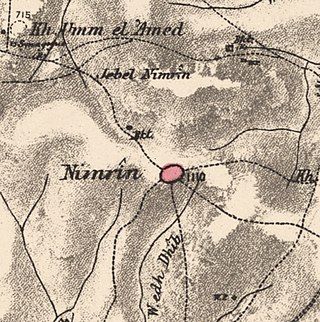
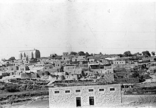
Nimrin was a Palestinian Arab town of 320 that was captured and depopulated by Israel during the 1948 Arab-Israeli War.

<span class="mw-page-title-main">Al-Khalisa</span> Place in Safad, Mandatory Palestine

Al-Khalisa was a Palestinian Arab village situated on a low hill on the northwestern edge of the Hula Valley of over 1,800 located 28 kilometers (17 mi) north of Safad. It was depopulated in the 1948 Palestine war.

<span class="mw-page-title-main">Ammuqa</span> Village in Safad, Mandatory Palestine

Ammuqa was a Palestinian village, located five kilometres northeast of Safed.

<span class="mw-page-title-main">Ein al-Zeitun</span> Village in Safad, Mandatory Palestine

Ein al-Zeitun, was a Palestinian Arab village, located 1.5 kilometres (0.93 mi) north of Safed in the Upper Galilee. During the early Ottoman period, Ein el-Zeitun had a mixed population of Muslims and Jews. Later, in the 19th century, it became entirely Muslim. The village's small population and land area as well as its proximity to Safad made it a suburb of the city. In 1945, the village had a population of 820 inhabitants and a total land area of 1,100 dunams. The village was depopulated in 1948, after the Ein al-Zeitun massacre.

<span class="mw-page-title-main">Qaddita</span> Village in Safad, Mandatory Palestine

Qaddita was a Palestinian Arab village of 240, located 4.5 kilometers (2.8 mi) northwest of Safad. It was captured and depopulated in the 1948 Arab-Israeli War, with some of its inhabitants expelled or fleeing to nearby 'Akbara where they live as internally displaced Palestinians and others to refugee camps in Lebanon or Syria.

<span class="mw-page-title-main">Al-Ja'una</span> Village in Safad, Mandatory Palestine

Al-Ja'una or Ja'ouna, was a Palestinian village situated in Galilee near al-Houleh Plateau, overlooking the Jordan Valley. The village lay on a hillside 450–500 meters above sea level, 5 kilometers east of Safad near a major road connecting Safad with Tabariya. The village had its Arab residents expelled by Zionist forces in 1948 and was thereafter resettled by Jews, becoming a part of the Israeli settlement of Rosh Pinna.

<span class="mw-page-title-main">Dallata</span> Place in Safad, Mandatory Palestine

Dallata was an Arab village, located on a hilltop 6 kilometers (3.7 mi) north of Safad. Constructed upon an ancient site, it was known to the Crusaders as Deleha. Dallata was included in the late 16th century Ottoman census and British censuses of the 20th century. Its inhabitants were primarily agriculturalists, with some involved in carpentry or trade.

<span class="mw-page-title-main">Fara, Safad</span> Village in Safad, Mandatory Palestine

Fara was a Palestinian Arab village in the Safad Subdistrict. It was depopulated during the 1948 Arab-Israeli War on October 30, 1948, under Operation Hiram. It was located 11.5 km north of Safad on the Wadi al-Fara.

<span class="mw-page-title-main">Jahula</span> Place in Safad, Mandatory Palestine

Jahula was a Palestinian Arab village in the Safad Subdistrict. It was depopulated during the 1947–1948 civil war in Mandatory Palestine on May 1, 1948, by the Palmach's First Battalion of Operation Yiftach. It was located 11 km northeast of Safad.

<span class="mw-page-title-main">Al-Ras al-Ahmar</span> Place in Safad, Mandatory Palestine

Al-Ras al-Ahmar was a Palestinian Arab village in the Safad Subdistrict. It was depopulated during the 1948 Arab–Israeli War on October 30, 1948, by the Israeli 7th Armored Brigade during Operation Hiram. It was located 8.5 km north of Safad.

<span class="mw-page-title-main">Al-Shawka al-Tahta</span> Place in Safad, Mandatory Palestine

Al-Shawka al-Tahta was a Palestinian Arab village in the Safad Subdistrict. It was depopulated during the 1947–1948 Civil War in Mandatory Palestine on May 14, 1948, by the Palmach's First Battalion of Operation Yiftach. It was located 31.5 km northeast of Safad.

<span class="mw-page-title-main">Al-Zuq al-Tahtani</span> Village in Safad, Mandatory Palestine

Al-Zuq al-Tahtani was a Palestinian Arab village in the Safad Subdistrict. It was depopulated during the 1947–1948 Civil War in Mandatory Palestine on May 11, 1948, by the Palmach's First Battalion of Operation Yiftach. It was located 30 km northeast of Safad.

<span class="mw-page-title-main">Qabba'a</span> Village in Safad, Mandatory Palestine

Qabba'a was a Palestinian Arab village in the District of Safad. It was depopulated during the 1948 War on May 26, 1948, by the Palmach's First Battalion of Operation Yiftach. It was located 6 km northeast of Safad.

<span class="mw-page-title-main">Al-Qudayriyya</span> Village in Safad, Mandatory Palestine

Al-Qudayriyya was a Palestinian Arab village in the Safad Subdistrict. It was depopulated during the 1947–1948 Civil War in Mandatory Palestine on May 4, 1948, by the Haganah and the Palmach's First Battalion of Operation Matate, a sub-operation of Operation Yiftach. It was located 6.5 km south of Safad, situated 1 km east of Wadi al-'Amud.

<span class="mw-page-title-main">Taytaba</span> Place in Safad, Mandatory Palestine

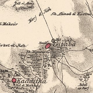
Taytaba was a Palestinian-Arab village in the Safad Subdistrict, located 5 kilometers north of Safad. It was depopulated during the 1947–1948 Civil War in Mandatory Palestine in May 1948 under Operation Hiram. In 1945 it had a population of 530 and a total area of 8,453 dunams, 99.8% of which was Arab-owned.

<span class="mw-page-title-main">Tulayl</span> Place in Safad, Mandatory Palestine

Tulayl was a Palestinian Arab village in the Safad Subdistrict located 14.5 kilometers (9.0 mi) northeast of Safad. It was situated on a hill near Lake Hula. Together with the nearby village of al-Husayniyya, it had a population of 340 in 1945. Tulayl was depopulated during the 1948 Palestine War.

<span class="mw-page-title-main">Al-'Ulmaniyya</span> Village in Safad, Mandatory Palestine

Al-'Ulmaniyya was a Palestinian Arab village in the Safad Subdistrict. It was depopulated during the 1947–1948 Civil War in Mandatory Palestine on April 20, 1948, by the Palmach's First Battalion of Operation Yiftach. It was located 14.5 km northeast of Safad.

<span class="mw-page-title-main">Al-Mansura, Tiberias</span> Village in Tiberias, Mandatory Palestine

Al-Mansura was a Palestinian Arab village in the Tiberias Subdistrict. It was depopulated during the 1947–1948 Civil War in Mandatory Palestine on May 10, 1948. It was located 16 kilometres northwest of Tiberias.

<span class="mw-page-title-main">Dayshum</span> Place in Safad, Mandatory Palestine

Dayshum, also known by its variant name Dayshun was a Palestinian village, depopulated on 30 October 1948 by the Sheva Brigade of Israeli paramilitary force Palmach in an offensive called Operation Hiram, where the village has been destroyed, and only house rubble left behind.

References

  1. 1 2 Morris, 2004, p. xvi, village #58. Also gives cause of depopulation
  2. 1 2 Palmer, 1881, p. 71
  3. Palmer, 1881, p. 93
  4. Grootkerk, 2000, p. 114, #51
  5. Palmer, 1881, p. 93
  6. Grootkerk, 2000, p. 114, #51
  7. 1 2 Village Statistics (PDF) (Report). Department of Statistics. April 1945. p. 9 via Brendan McKay, Australian National University.
  8. 1 2 "Safad". Village Statistics 1945: A Classification of Land and Area Ownersip in Palestine (Report). Beirut: Palestine Liberation Organization Research Center. April 1945. pp. 69, 71.
  9. 1 2 Khalidi, 1992, p. 506
  10. 1 2 3 4 Khalidi, 1992, p. 505
  11. Hütteroth and Abdulfattah, 1977, p. 175
  12. Note that Rhode, 1979, p. 6 Archived 2019-04-20 at the Wayback Machine writes that the register that Hütteroth and Abdulfattah studied was not from 1595/6, but from 1548/9
  13. Karmon, 1960, p. 165 Archived 2017-12-01 at the Wayback Machine Note wrong grid: 197/264
  14. Robinson and Smith, 1841, vol 3, Appendix 2, p. 134
  15. Conder and Kitchener, 1881, SWP I, p. 197
  16. Schumacher, 1888, p. 188
  17. Barron, 1923, Table XI, Sub-district of Safad, p. 41
  18. Mills, 1932, p. 106
  19. Government of Palestine, Department of Statistics. Village Statistics, April, 1945. Quoted in Hadawi, 1970, p. 118
  20. Government of Palestine, Department of Statistics. Village Statistics, April, 1945. Quoted in Hadawi, 1970, p. 168
  21. Morris 2004, pp. 249250
  22. Al-Waridat, 2003; cited in Davis, 2011, p. 285

Bibliography