Al-Ashrafiyya

Last updated

Contents

Al-Ashrafiyya
الأشرفية
Ashrafiya [1]
Historical map series for the area of al-Ashrafiyya (1870s).jpg 1870s map
Historical map series for the area of al-Ashrafiyya (1940s).jpg 1940s map
Historical map series for the area of al-Ashrafiyya (modern).jpg modern map
Historical map series for the area of al-Ashrafiyya (1940s with modern overlay).jpg 1940s with modern overlay map
A series of historical maps of the area around Al-Ashrafiyya (click the buttons)
Mandatory Palestine location map.svg
Red pog.svg
Al-Ashrafiyya
Location within Mandatory Palestine
Coordinates: 32°28′12″N35°28′17″E / 32.47000°N 35.47139°E / 32.47000; 35.47139
Palestine grid 194/208
Geopolitical entity Mandatory Palestine
Subdistrict Baysan
Date of depopulationMay 12, 1948 [1]
Area
[2]
  Total
6,711  dunams (6.711 km2 or 2.591 sq mi)
Population
 (1945)
  Total
230 [3] [2]
Cause(s) of depopulationInfluence of nearby town's fall
Current Localities Sheluhot, [4] [5] Reshafim [4] [6]

Al-Ashrafiyya (Arabic : الأشرفية), was a Palestinian Arab village in the District of Baysan. It was depopulated during the 1947–1948 Civil War in Mandatory Palestine. It was located 4.5 km southwest of Baysan.

The village was depopulated on May 12, 1948, during Operation Gideon. The village was completely destroyed and the inhabitants fled to Jordan.

History

Just east of the village site, (at 196/208) pottery remains from the Byzantine era have been found, together with coins dating to the time of Justinian I (527–565 C.E.). [7]

British Mandate era

In the 1922 census of Palestine, conducted by the Mandatory Palestine authorities, Ashrafiyet Kuzma had 29 inhabitant; 27 Muslims and 2 Christians, while Ashrafiyet Rushdi had 7 Muslims; a total of 36 inhabitants. [8] The 2 Christians were Roman Catholics. [9]

In the 1931 census there were 4 villages named Ashrafiyat, where Ashrafiyat Kazma had 123 Muslims and 2 Christians in a total of 34 houses, while the three others were all Muslims; 48 in 11 houses in Ashrafiyat Abd el Hadi, 10 in 3 houses in Ashrafiyat Haddad, and 36 in 10 houses in Ashrafiyat Zamriq. In total there were 219 inhabitants in a total of 58 houses. [10]

In the 1945 statistics, the population consisted of 230 Muslims, [3] and the land area was 6711 dunams, according to an official land and population survey. [2] Of this, the land ownership census the Land Ownership (Dunums) was as follows: [2]

OwnerDunams
Arab4,608
Jewish1,293
Public810
Total6,711

The use of village land in 1945: [11] [12]

Land UsageArabJewishPublic
Citrus and bananas14311-
Irrigated and plantation4,458772-
Cereal7510583
Urban---
Cultivable4,6081,293583
Non-cultivable--227

The population rose to 267 in 1948 with 61 houses. The Wadi al-Maddu' runs near where the village was located.

1948, aftermath

In March, 1948, Yosef Weitz had started pressing the Haganah to expel Arab tenant farmers, and kibbutz leaders in the Baysan valley had demanded new settlements in their area, as "a means of freeing our land [from Arabs] and preventing the return of the beduins who had fled to Transjordan". On 22 April, 1948, Haganah agreed to set up five new settlements on non-Arab land, including land in Al-Ashrafiyya. [13] [14]

The Palestinian inhabitants of Al-Ashrafiyya, along with those of the neighbouring village of Farwana, fled to Jordan with the approach of the pre-state Israeli forces of the Golani Brigade during Operation Gideon on 11 May 1948. [15]

Following the war the area was incorporated into the State of Israel and two kibbutzim were established on village land in 1948, Shluhot and Reshafim, both east of the village site. [4]

In 1992, it was described: "The site and the area around it are cultivated by the residents of Reshafim. A fishery also has been built on the site." [4]

See also

Related Research Articles

<span class="mw-page-title-main">Al-Ghazzawiyya</span> Place in Baysan, Mandatory Palestine

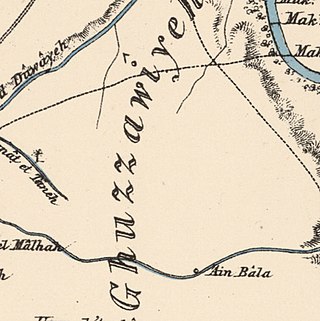
Al-Ghazzawiyya, was a Palestinian village located 2 kilometers east of the city of Bet Shean (Bisan). In 1945, the population was 1,640, 1,020 Arab and 620 Jewish.

<span class="mw-page-title-main">Qumya</span> Village in Baysan, Mandatory Palestine

Qumya, was a Palestinian village of 510 inhabitants when it was depopulated prior to the 1948 Arab-Israeli war.

<span class="mw-page-title-main">Farwana</span> Place in Baysan, Mandatory Palestine

Farwana, was a Palestinian village, located 4.5 kilometers (2.8 mi) south of Bisan, depopulated in 1948.

<span class="mw-page-title-main">Yubla</span> Village in Baysan, Mandatory Palestine

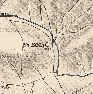
Yubla, was a Palestinian village, located 9 kilometers north of Bisan in present-day Israel. It was depopulated during the 1948 Arab-Israeli war.

<span class="mw-page-title-main">Jabbul</span> Place in Baysan, Mandatory Palestine

Jabbul, is a depopulated former Palestinian Arab village located 7 km north of Baysan. During Operation Gideon, the village was occupied by the Golani Brigade.

<span class="mw-page-title-main">Nasir ad-Din, Palestine</span> Village in Tiberias, Mandatory Palestine

Nasir ad-Dīn was a small Palestinian Arab village 3 kilometers (1.9 mi) southwest of Tiberias, on the crest of a slope that overlooks the Sea of Galilee. The village had several springs to the east, south, and southeast. In the 1931 British census 179 people lived there, decreasing to 90 in a 1945 census. Nasir ad-Din and nearby al-Manara were in the same jurisdiction with 4,185 dunams of land, most of which was allocated to cereals.

<span class="mw-page-title-main">Arab al-Bawati</span> Village in Baysan, Mandatory Palestine

Arab al-Bawati, was a Palestinian Arab village in the District of Baysan. It was depopulated during the 1948 Arab-Israeli War.

<span class="mw-page-title-main">Arab al-Safa</span> Village in Baysan, Mandatory Palestine

Arab al-Safa, was a Palestinian Arab village in the District of Baysan. It was depopulated during the 1948 Arab-Israeli War. It was located 7.5 km south of Baysan.

<span class="mw-page-title-main">Al-Hamidiyya</span> Place in Baysan, Mandatory Palestine

Al-Hamidiyya, was a Palestinian village in the District of Baysan. It was depopulated by the Jewish militias, precursors of the Israel Defense Forces, during the 1947–1948 Civil War in Mandatory Palestine on May 12, 1948. It was located five kilometres north of Baysan. It was attacked as part of Operation Gideon. The population in 1922 was 193, expanding to 255 in 1948.

<span class="mw-page-title-main">Al-Khunayzir</span> Village in Baysan, Mandatory Palestine

Al-Khunayzir, was a Palestinian Arab village in the District of Baysan. It was depopulated during the 1948 Arab-Israeli War on May 20, 1948.

<span class="mw-page-title-main">Masil al-Jizl</span> Village in Baysan, Mandatory Palestine

Masil al-Jizl was a Palestinian Arab village in the District of Baysan. It was depopulated by the Israel Defense Forces during the Arab-Israeli War. It was attacked and depopulated on May 31, 1948, as part of Operation Gideon.

<span class="mw-page-title-main">Al-Murassas</span> Place in Baysan, Mandatory Palestine

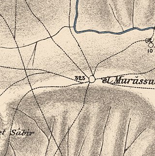
Al-Murassas, was a Palestinian Arab village in the District of Baysan. It was depopulated by the Israel Defense Forces during the 1948 War on May 16, 1948. The village was attacked as part of Operation Gideon.

<span class="mw-page-title-main">Al-Sakhina</span> Place in Baysan, Mandatory Palestine

Al-Sakhina, was a Palestinian Arab village in the District of Baysan. It was located five kilometres west of Baysan on the Jalud River on its way to the Jordan River. It was depopulated by the Israel Defense Forces during the 1947–1948 Civil War in Mandatory Palestine on May 12, 1948, as part of Operation Gideon.

<span class="mw-page-title-main">Al-Samiriyya</span> Village in Baysan, Mandatory Palestine

Al-Samiriyya, was a Palestinian Arab village in the District of Baysan. It was depopulated by the Israel Defense Forces during the 1948 Arab-Israeli War on May 27, 1948, as part of Operation Gideon. It was located 7 km southeast of Baysan.

<span class="mw-page-title-main">Tall al-Shawk</span> Village in Baysan, Mandatory Palestine

Tall al-Shawk, was a Palestinian village in the District of Baysan. It was depopulated by the Israel Defense Forces during the 1947–1948 Civil War in Mandatory Palestine on May 12, 1948, as part of Operation Gideon. It was located five km west of Baysan between the al-Januna'in River to the north and Wadi al-Jawsaq to the south. The village was built above an ancient archeological site and granite columns remain.

<span class="mw-page-title-main">Al-Tira, Baysan</span> Village in Baysan, Mandatory Palestine

Al-Tira, was a Palestinian Arab village in the District of Baysan. It was depopulated by the Israel Defense Forces during the 1947–48 Civil War in Mandatory Palestine on 15 April 1948 as part of Operation Gideon under the command of Yosef Weitz. It was located 17.5 km north of Baysan overlooking Wadi al-Bira. However, 'Ayn al-Bayda' was the main source of drinking water for al-Tira inhabitants.

<span class="mw-page-title-main">Umm 'Ajra</span> Village in Baysan, Mandatory Palestine

Umm 'Ajra, was a Palestinian Arab village in the District of Baysan. It was depopulated by the Israel Defense Forces during the 1948 Arab-Israeli War on May 31, 1948, as part of Operation Gideon. It was located 4 km south of Baysan and the 'Ayn Umm 'Ajra provided the village with water.

<span class="mw-page-title-main">Arab Zahrat al-Dumayri</span> Place in Haifa, Mandatory Palestine

Arab Zahrat al-Dumayri was a Palestinian Arab village in the Haifa Subdistrict. It was depopulated during the 1947–1948 Civil War in Mandatory Palestine on April 10, 1948. It was located 40 km south of Haifa.

<span class="mw-page-title-main">Daliyat al-Rawha'</span> Arab village in Haifa subdistrict, Mandatory Palestine

Daliyat al-Rawha' was a Palestinian village located 24.5 kilometers (15.2 mi) southeast of Haifa. It was the site of the signing of a ceasefire agreement between the forces of the Mamluks and the Crusaders in the 13th century. A small village of 60 Arab Muslims in the late 19th century, the kibbutz of Dalia was established on land purchased in the village in 1939. The population in 1945 reached 600 people: 280 Arabs and 320 Jews. It was depopulated of its Arab inhabitants in late March during the 1947–1948 civil war in Mandatory Palestine. Its remains lie at the very center of the Ramat Menashe Park of the JNF covered by the kibbutz of the same name.

<span class="mw-page-title-main">Al-Jammasin al-Gharbi</span> Village in Jaffa, Mandatory Palestine

Al-Jammasin al-Gharbi was a Palestinian Arab village in the Jaffa Subdistrict. It was depopulated during the 1947–48 Civil War in Mandatory Palestine on March 17, 1948. It was located 6.5 km northeast of Jaffa.

References

  1. 1 2 Morris, 2004, p. xvii, village #127. Also gives cause of depopulation, with a "?"
  2. 1 2 3 4 Government of Palestine, Department of Statistics. Village Statistics, April, 1945. Quoted in Hadawi, 1970, p. 43
  3. 1 2 Government of Palestine, Department of Statistics, 1945, p. 6
  4. 1 2 3 4 Khalidi, 1992, p. 44
  5. Morris, 2004, p. xx, settlement #2
  6. Morris, 2004, p. xx, settlement #3
  7. Dauphin, 1992, p. 785
  8. Barron, 1923, Table IX, p. 31
  9. Barron, 1923, Table XV, p. 48
  10. Mills, 1932, p. 77
  11. Government of Palestine, Department of Statistics. Village Statistics, April, 1945. Quoted in Hadawi, 1970, p. 84
  12. Government of Palestine, Department of Statistics. Village Statistics, April, 1945. Quoted in Hadawi, 1970, p. 134
  13. Morris, 2004, p. 372, notes #176 and #177
  14. Morris, 2004, p. 405, note #176 and #177. #177: 26 March, 1948, entry in Weitz diary. "This is the first documented linkage between the establishment of new settlements and the prevention of a return. The two settlements, kibbutzim Sheluhot and Reshafim, were established in the valley, on Ashrafiyya lands, on 10 June 1948."
  15. Morris, 2004, p. 227

Bibliography