Al-Tira, Baysan

Last updated

Contents

See Tira for other sites with similar names.
Al-Tira
الطيرة
Village
Etymology: "The Fort of Abu Amran" [1]
Historical map series for the area of al-Tira, Baysan (1870s).jpg 1870s map
Historical map series for the area of al-Tira, Baysan (1940s).jpg 1940s map
Historical map series for the area of al-Tira, Baysan (modern).jpg modern map
Historical map series for the area of al-Tira, Baysan (1940s with modern overlay).jpg 1940s with modern overlay map
A series of historical maps of the area around Al-Tira, Baysan (click the buttons)
Mandatory Palestine location map.svg
Red pog.svg
Al-Tira
Location within Mandatory Palestine
Coordinates: 32°38′52″N35°27′26″E / 32.64778°N 35.45722°E / 32.64778; 35.45722
Palestine grid 193/228
Geopolitical entity Mandatory Palestine
Subdistrict Baysan
Date of depopulation15 April 1948 [2]
Area
[3]
  Total
10,207  dunams (10.207 km2 or 3.941 sq mi)
Population
 (1945)
  Total
150 [4] [3]
Cause(s) of depopulationWhispering campaign
Current Localities Gazit [5] [6]

Al-Tira (Arabic : الطيرة), was a Palestinian Arab village in the District of Baysan. It was depopulated by the Israel Defense Forces during the 1947–48 Civil War in Mandatory Palestine on 15 April 1948 as part of Operation Gideon under the command of Yosef Weitz. It was located 17.5 km north of Baysan overlooking Wadi al-Bira. However, 'Ayn al-Bayda' was the main source of drinking water for al-Tira inhabitants.

History

It has been suggested that this was Atara of the list of Thothmes III. [7] [8]

In 1517 al-Tra was incorporated into the Ottoman Empire with the rest of Palestine. During the 16th and 17th centuries, it belonged to the Turabay Emirate (1517-1683), which encompassed also the Jezreel Valley, Haifa, Jenin, Beit She'an Valley, northern Jabal Nablus, Bilad al-Ruha/Ramot Menashe, and the northern part of the Sharon plain. [9] [10]

In 1875, Victor Guérin climbed a small hill to reach the Al-Tira village. It consisted of about a dozen houses, built of adobe or assorted materials. [11] In 1882, the PEF's Survey of Western Palestine described it as: "A small village, principally of adobe, on a hill-top, above a deep gorge. The water appears to be brought from the springs in the valley." [8]

British Mandate era

In the 1922 census of Palestine, conducted by the Mandatory Palestine authorities, Tireh had a population of 130 Muslims, [12] decreasing in the 1931 census to 108, still all Muslims, in 24 houses. [13]

In the 1945 statistics the population of Et Tira and Irgun Borokhov was 200; 150 Arabs and 50 Jews, while the total land area was 10,207 dunams, according to an official land and population survey. [4] [3] Of this, Arabs used 54 dunums for plantations and irrigable land, 4,326 for cereals, [14] while 29 dunums were classified as built-up (urban) land. [15]

1948, aftermath

In his diary, Weitz wrote of the inhabitants of Qumya and Al-Tira in the Baysan valley on the 26 March 1948:

"Not taking upon themselves the responsibility of preventing the infiltration of irregulars ... They must be forced to leave their villages until peace comes. [16]

In order to block the return of the villagers, [17] the kibbutz Gazit was established on the land of village land in September 1948, 1.5 km southwest of the village site. [5] [6]

In 1992 the village site was described: "The ruins of stone houses, covered with grass and thorns, are all that remain of al-Tira. The site is fenced in and servers Israeli farmers as pasture land. Cupress trees grow on surrounding land." [18]

Related Research Articles

<span class="mw-page-title-main">Bayt Nabala</span> Place in Ramle, Mandatory Palestine

Bayt Nabala or Beit Nabala was a Palestinian Arab village in the Ramle Subdistrict in Palestine that was destroyed during the 1948 Arab–Israeli War. The village was in the territory allotted to the Arab state under the 1947 UN Partition Plan, which was rejected by Arab leaders and never implemented. Its population in 1945, before the war, was 2,310.

<span class="mw-page-title-main">Qumya</span> Village in Baysan, Mandatory Palestine

Qumya, was a Palestinian village of 510 inhabitants when it was depopulated prior to the 1948 Arab-Israeli war.

<span class="mw-page-title-main">Yubla</span> Village in Baysan, Mandatory Palestine

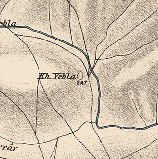
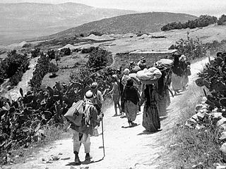
Yubla, was a Palestinian village, located 9 kilometers north of Bisan in present-day Israel. It was depopulated during the 1948 Arab-Israeli war.

<span class="mw-page-title-main">Miska, Tulkarm</span> Village in Tulkarm, Mandatory Palestine

Miska was a Palestinian village, located fifteen kilometers southwest of Tulkarm, depopulated in 1948.

<span class="mw-page-title-main">Jabbul</span> Place in Baysan, Mandatory Palestine

Jabbul, is a depopulated former Palestinian Arab village located 7 km north of Baysan. During Operation Gideon, the village was occupied by the Golani Brigade.

<span class="mw-page-title-main">Kawkab al-Hawa</span> Place in Baysan, Mandatory Palestine

Kawkab al-Hawa, is a depopulated former Palestinian village located 11 km north of Baysan. It was built within the ruins of the Crusader fortress of Belvoir, from which it expanded. The Crusader names for the Frankish settlement at Kawkab al-Hawa were Beauvoir, Belvoir, Bellum videre, Coquet, Cuschet and Coket. During Operation Gideon in 1948, the village was occupied by the Golani Brigade and depopulated.

<span class="mw-page-title-main">Al-Bira, Baysan</span> Village in Baysan, Mandatory Palestine

Al-Bira, is a depopulated former Palestinian village located 7.5 km north of Baysan. During Operation Gideon, the village was occupied by the Golani Brigade.

<span class="mw-page-title-main">Arab al-Bawati</span> Village in Baysan, Mandatory Palestine

Arab al-Bawati, was a Palestinian Arab village in the District of Baysan. It was depopulated during the 1948 Arab-Israeli War.

<span class="mw-page-title-main">Al-Murassas</span> Place in Baysan, Mandatory Palestine

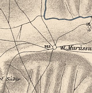
Al-Murassas, was a Palestinian Arab village in the District of Baysan. It was depopulated by the Israel Defense Forces during the 1948 War on May 16, 1948. The village was attacked as part of Operation Gideon.

<span class="mw-page-title-main">Al-Samiriyya</span> Village in Baysan, Mandatory Palestine

Al-Samiriyya, was a Palestinian Arab village in the District of Baysan. It was depopulated by the Israel Defense Forces during the 1948 Arab-Israeli War on May 27, 1948, as part of Operation Gideon. It was located 7 km southeast of Baysan.

<span class="mw-page-title-main">Tall al-Shawk</span> Village in Baysan, Mandatory Palestine

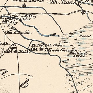
Tall al-Shawk, was a Palestinian village in the District of Baysan. It was depopulated by the Israel Defense Forces during the 1947–1948 Civil War in Mandatory Palestine on May 12, 1948, as part of Operation Gideon. It was located five km west of Baysan between the al-Januna'in River to the north and Wadi al-Jawsaq to the south. The village was built above an ancient archeological site and granite columns remain.

<span class="mw-page-title-main">Umm 'Ajra</span> Village in Baysan, Mandatory Palestine

Umm 'Ajra, was a Palestinian Arab village in the District of Baysan. It was depopulated by the Israel Defense Forces during the 1948 Arab-Israeli War on May 31, 1948, as part of Operation Gideon. It was located 4 km south of Baysan and the 'Ayn Umm 'Ajra provided the village with water.

<span class="mw-page-title-main">Bayt Umm al-Mays</span> Place in Jerusalem, Mandatory Palestine

Bayt Umm al-Mays was a small Palestinian Arab village in the Jerusalem Sub-district, located 14 km west of Jerusalem..

<span class="mw-page-title-main">Al-Barriyya</span> Place in Ramle, Mandatory Palestine

Al-Barriyya was a Palestinian village in the Ramle Subdistrict of Mandatory Palestine. It was depopulated during the 1948 Arab–Israeli War on July 10, 1948, as part of Operation Dani. It was located 5.5 km southeast of Ramla, on the eastern bank of Wadi al-Barriyya.

<span class="mw-page-title-main">Al-Haditha, Ramle</span> Place in Ramle, Mandatory Palestine

Al-Haditha was a Palestinian village in the Ramle Subdistrict. It was located 8 km northeast of Ramla, on the bank of Wadi al-Natuf. The site, now known as Tel Hadid, has yielded significant archaeological remains from many periods. Al-Haditha was depopulated during the 1948 Arab-Israeli War on July 12, 1948, under the first stage of Operation Dani.

<span class="mw-page-title-main">Al-Khayma</span> Village in Ramle, Mandatory Palestine

Al-Khayma was a Palestinian Arab village in the Ramle Subdistrict of Mandatory Palestine. It was depopulated during the 1948 Arab–Israeli War on July 9, 1948, by the Givati Brigade of Operation An-Far. It was located 18.5 km south of Ramla.

<span class="mw-page-title-main">Al-Mansura, Ramle</span> Village in Ramle, Mandatory Palestine

Al-Mansura was a small Palestinian Arab village in the Ramle Subdistrict, located 10 km south of Ramla. It was depopulated during the 1947–48 Civil War in Mandatory Palestine on April 20, 1948, under Operation Barak.

<span class="mw-page-title-main">Arab al-Shamalina</span> Place in Safad, Mandatory Palestine

Arab al-Shamalina also known as Khirbat Abu Zayna was a Palestinian Arab village in the Safad Subdistrict. It was depopulated during the 1947–1948 Civil War in Mandatory Palestine on May 4, 1948, under Operation Matate (Broom), a sub operation of Operation Yiftach. It was located 13 km southeast of Safad near the Jordan River.

<span class="mw-page-title-main">Al-Zuq al-Tahtani</span> Village in Safad, Mandatory Palestine

Al-Zuq al-Tahtani was a Palestinian Arab village in the Safad Subdistrict. It was depopulated during the 1947–1948 Civil War in Mandatory Palestine on May 11, 1948, by the Palmach's First Battalion of Operation Yiftach. It was located 30 km northeast of Safad.

<span class="mw-page-title-main">Khirbat al-Zababida</span> Place in Tulkarm, Mandatory Palestine

Khirbat al-Zababida was a Palestinian Arab village in the Tulkarm Subdistrict. It was depopulated during the 1948 Arab–Israeli War on May 15, 1948. It was located 20 kilometres (12 mi) southwest of Tulkarm, south of Wadi al-Faliq. Khirbat al-Zababida was mostly destroyed except for four deserted houses.

References

  1. Palmer, 1881, p. 170
  2. Morris, 2004, p. xvii, village #109. Also gives cause of depopulation
  3. 1 2 3 Government of Palestine, Department of Statistics. Village Statistics, April, 1945. Quoted in Hadawi, 1970, p. 44
  4. 1 2 Government of Palestine, Department of Statistics, 1945, p. 7
  5. 1 2 Morris, 2004, p. xxi, settlement #25.
  6. 1 2 Khalidi, 1992, p. 63.
  7. Conder, 1876, p. 146
  8. 1 2 Conder and Kitchener, 1882, SWP II, p. 87
  9. al-Bakhīt, Muḥammad ʻAdnān; al-Ḥamūd, Nūfān Rajā (1989). "Daftar mufaṣṣal nāḥiyat Marj Banī ʻĀmir wa-tawābiʻihā wa-lawāḥiqihā allatī kānat fī taṣarruf al-Amīr Ṭarah Bāy sanat 945 ah". www.worldcat.org. Amman: Jordanian University. pp. 1–35. Retrieved 2023-05-15.
  10. Marom, Roy; Marom, Tepper; Adams, Matthew, J (2023). "Lajjun: Forgotten Provincial Capital in Ottoman Palestine" (PDF). Levant. 55 (2): 218–241. doi:10.1080/00758914.2023.2202484. S2CID   258602184.{{cite journal}}: CS1 maint: multiple names: authors list (link)
  11. Guérin, 1880, p. 139
  12. Barron, 1923, Table IX, p. 31
  13. Mills, 1932, p. 81
  14. Government of Palestine, Department of Statistics. Village Statistics, April, 1945. Quoted in Hadawi, 1970, p. 85
  15. Government of Palestine, Department of Statistics. Village Statistics, April, 1945. Quoted in Hadawi, 1970, p. 135
  16. Morris, 2004, p. 132, note #538 on p. 160
  17. Morris, 2004, p. 380
  18. Khalidi, 1992, pp. 63-64

Bibliography