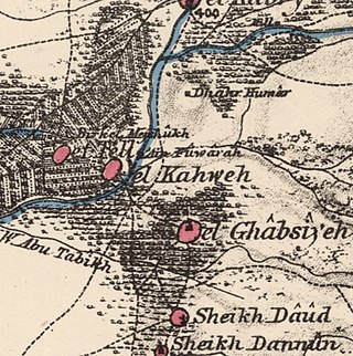
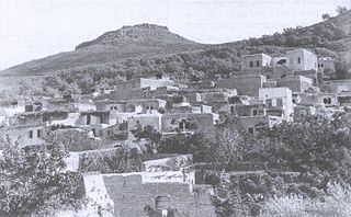
Al-Ghabisiyya was a Palestinian Arab village in northern Palestine, 16 km north-east of Acre in present-day Israel. It was depopulated by the Israel Defense Forces during the 1948 Palestinian expulsion and remains deserted.

Kuwaykat, also spelled Kuweikat, Kweikat or Kuwaikat, was a Palestinian village located 9 km northeast of Acre. It was depopulated in 1948.
Hittin was a Palestinian village located 8 kilometers (5 mi) west of Tiberias before it was occupied by Israel during the 1948 Arab-Israeli war when most of its original residents became refugees after being ethnically cleansed. As the site of the Battle of Hattin in 1187, in which Saladin reconquered most of Palestine from the Crusaders, it has become an Arab nationalist symbol. The shrine of Nabi Shu'ayb, venerated by the Druze and Sunni Muslims as the tomb of Jethro, is on the village land. The village was ruled by the Ottoman Empire from the 16th century until the end of World War I, when Palestine became part of the British Mandate for Palestine. On July 17 1948, the village was occupied by Israel during the nakbaa, after its residents fled out of their homes because of Nazareth's occupation. in later years, the Moshavs Arbel and Kfar Zeitim were erected where Hittin used to be.
Umm Khalid, also called Mukhalid, was a Palestinian village in the Tulkarm Subdistrict, 15 kilometers (9.3 mi) west of Tulkarm. It was an ancient site in the central coastline of what is now the city of Netanya, Israel.

Al-Shaykh Muwannis, also Sheikh Munis, was a small Palestinian Arab village in the Jaffa Subdistrict of Mandatory Palestine, located approximately 8.5 kilometers from the center of Jaffa city in territory earmarked for Jewish statehood under the UN Partition Plan. The village was abandoned in March 1948 due to the threats of Jewish militias, two months before the 1948 Arab–Israeli war. Today, Tel Aviv University lies on part of the village land.

Al-Khayriyya, also Ibn Ibraq, was a Palestinian Arab village located 7.5 kilometers east of Jaffa. It became depopulated in April 1948 as a result of a military assault by the Alexandroni Brigade of the pre-state Israeli forces during the 1948 Palestine war. The village lands would later be used by Israel as the Hiriya landfill.
Al-Khalisa was a Palestinian Arab village situated on a low hill on the northwestern edge of the Hula Valley of over 1,800 located 28 kilometers (17 mi) north of Safad. It was depopulated in the 1948 Palestine war.

Yazur was a Palestinian Arab town located 6 kilometers (3.7 mi) east of Jaffa. Mentioned in 7th century BCE Assyrian texts, the village was a site of contestation between Muslims and Crusaders in the 12th-13th centuries.

Salamah was a Palestinian Arab village, located five kilometers east of Jaffa, that was depopulated in the lead-up to the 1948 Arab-Israeli War. The town contains the supposed grave of Salama Abu Hashim, a companion of the Islamic prophet Muhammad. His tomb, two village schools, and ten houses from among the over 800 houses that had made up the village, are all that remain of the structures of the former village today.

Miska was a Palestinian village, located fifteen kilometers southwest of Tulkarm, depopulated in 1948.
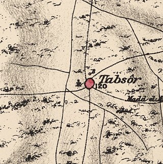
Tabsur, also Khirbat 'Azzun, was a Palestinian village located 19 kilometres southwest of Tulkarm. In 1931, the village had 218 houses and an elementary school for boys. Its Palestinian population was expelled during the 1948 Arab-Israeli war.
Artuf was a Palestinian village in the Jerusalem foothills depopulated in 1948. It was situated 21.5 kilometers (13.4 mi) west of Jerusalem on a high plateau, surrounded by plains on the south, east, and west. The village was on a secondary road that linked it to the main road to Jerusalem.

Jarisha was a Palestinian Arab village located 200 meters (660 ft) from the ancient site of Tell Jarisha, on the south bank of Al-Awja. After the establishment of Tel Aviv, it was one of five Arab villages to fall within its municipal boundaries. Jarisha was depopulated in the lead up to the 1948 Arab-Israeli war.

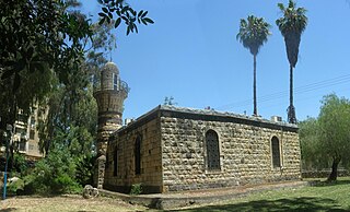
The Sidna 'Ali Mosque is a mosque located in the depopulated Palestinian village of Al-Haram on the beach in the northern part of Herzliya in Israel. It served, as of 1998, as both a mosque and a religious school.

Burayka was a Palestinian Arab village in the Haifa Subdistrict. It was depopulated during the 1947–1948 Civil War in Mandatory Palestine on May 5, 1948. It was located 29 km south of Haifa.

Abu Kishk was a Palestinian village in the Jaffa Subdistrict located 12 km northeast of Jaffa, situated 2 km northwest of the Yarkon River. The village was depopulated during the 1947–1948 Civil War in Mandatory Palestine on 30 March 1948 by the Irgun.

Ijlil al-Qibliyya, also al-Jalil, was a Palestinian Arab village in the Jaffa Subdistrict. It was depopulated during the 1947–1948 Civil War in Mandatory Palestine on April 3, 1948.

Ijlil al-Shamaliyya was a Palestinian Arab village in the Jaffa Subdistrict. Established in the 19th century, it was founded by Bani Sa'b tribesmen from the Qalqiliya area and migrants from Egypt. It was depopulated during the 1947–1948 Civil War in Mandatory Palestine on April 3, 1948.
Al-Jammasin al-Sharqi was a Palestinian Arab village in the Jaffa Subdistrict. It was depopulated during the 1948 Palestine War on March 17, 1948. It was located 9 km northeast of Jaffa.

Al-Safiriyya was a Palestinian Arab village in the Jaffa Subdistrict. It was depopulated during Operation Hametz in the 1948 Palestine War on May 20, 1948. It was located 11 km east of Jaffa, 1.5 km west of Ben Gurion Airport.

 1870s map
  1940s map
 modern map
  1940s with modern overlay map

