
Ma'alul was a Palestinian village, with a mixed population of primarily Muslims with a substantial minority of Palestinian Christians, that was depopulated and destroyed by Israel during the 1948 Arab-Israeli war. Located six kilometers west of the city of Nazareth, many of its inhabitants became internally displaced refugees, after taking refuge in Nazareth and the neighbouring town of Yafa an-Naseriyye. Despite having never left the territory that came to form part of Israel, the majority of the villagers of Maalul, and other Palestinian villages like Andor and Al-Mujidal, were declared "absentees", allowing the confiscation of their land under the Absentees Property Law.
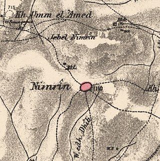
Nimrin was a Palestinian Arab town of 320 that was captured and depopulated by Israel during the 1948 Arab-Israeli War.
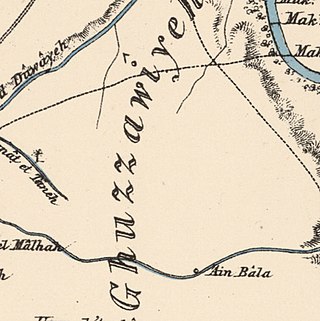
Al-Ghazzawiyya, was a Palestinian village located 2 kilometers east of the city of Bet Shean (Bisan). In 1945, the population was 1,640, 1,020 Arab and 620 Jewish.

Al-Shajara was a Palestinian Arab village depopulated by Israel during the 1948 Arab-Israeli War when its residents were forcefully evacuated and became refugees. It was located 14 kilometers west of Tiberias on the main highway to Nazareth near the villages of Lubya and Hittin. The village was very close to the city of Nazareth, about 5 kilometers away.

Nasir ad-Dīn was a small Palestinian Arab village 3 kilometers (1.9 mi) southwest of Tiberias, on the crest of a slope that overlooks the Sea of Galilee. The village had several springs to the east, south, and southeast. In the 1931 British census 179 people lived there, decreasing to 90 in a 1945 census. Nasir ad-Din and nearby al-Manara were in the same jurisdiction with 4,185 dunams of land, most of which was allocated to cereals.

Arab Zahrat al-Dumayri was a Palestinian Arab village in the Haifa Subdistrict. It was depopulated during the 1947–1948 Civil War in Mandatory Palestine on April 10, 1948. It was located 40 km south of Haifa.

Al-Kunayyisa was a small Palestinian Arab village in the Ramle Subdistrict. It was depopulated during the 1948 Arab–Israeli War on July 10, 1948, under the first stage of Operation Dani. It was located 12 km southeast of Ramla.

Arab al-Shamalina also known as Khirbat Abu Zayna was a Palestinian Arab village in the Safad Subdistrict. It was depopulated during the 1947–1948 Civil War in Mandatory Palestine on May 4, 1948, under Operation Matate (Broom), a sub operation of Operation Yiftach. It was located 13 km southeast of Safad near the Jordan River.
Arab al-Zubayd was a Palestinian village in the Safad Subdistrict. It was depopulated during the 1947–1948 Civil War in Mandatory Palestine on April 20, 1948, when the villagers fled on hearing the intentions of The Palmach's First Battalion of Operation Yiftach. It was located 15 km northeast of Safad, near the al-Mutilla-Safad—Tiberias highway.
Al-Dawwara was a Palestinian Arab village in the Safad Subdistrict. It was depopulated during the 1948 War on May 25, 1948, by the Palmach's First Battalion of Operation Yiftach. It was located 27 km northeast of Safad, bordering three rivers that flowed into lake al-Hula: the al-Hasbani, Banyas, and Dan rivers.

Jahula was a Palestinian Arab village in the Safad Subdistrict. It was depopulated during the 1947–1948 civil war in Mandatory Palestine on May 1, 1948, by the Palmach's First Battalion of Operation Yiftach. It was located 11 km northeast of Safad.

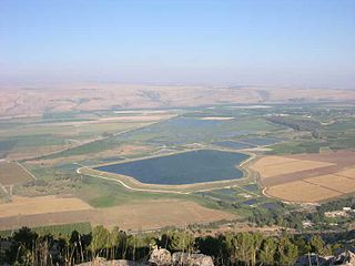
Kirad al-Ghannama was a Palestinian Arab village in the Safad Subdistrict. It was depopulated during the 1947–1948 Civil War in Mandatory Palestine on April 22, 1948, by the Palmach's First Battalion of Operation Yiftach. It was located 11 km northeast of Safad. Wadi Mushayrifa ran between the two Kirad villages and Wadi Waqqas supplied the village with its water requirements. The village contained the following khirbas: Khirbat Nijmat al-Subh, Tall al-Qadah, and Tall al-Safa.
Khiyam al-Walid was a Palestinian Arab village in the Safad Subdistrict located 25.5 kilometers (15.8 mi) northeast of Safad along the Syrian border. It was on situated on a hill 150 meters (490 ft) above sea level on the eastern edge of the Hula Valley. In 1945, there were 280 predominantly Muslim inhabitants. It was depopulated during the 1948 Palestine War.
Kirad al-Baqqara was a Palestinian Arab village in the Safad Subdistrict. It was depopulated during the 1947–1948 Civil War in Mandatory Palestine on April 22, 1948, by the Palmach's First Battalion of Operation Yiftach. It was located 11 km northwest of Safad and Wadi Mushayrifa ran between the two Kirad villages.

Al-Hamma was a Palestinian Arab village in the Tiberias Subdistrict, 12 kilometres (7.5 mi) southeast of Tiberias. It was situated on a narrow salient in the Yarmouk Valley bounded by Syria to the north and Transjordan to the south and east. Al-Hamma was one of the stations on the Jezreel Valley railway, linking the Hejaz Railway to Haifa. It was depopulated twice, once in July 1949, and again between 1949 and 1956.

Khirbat al-Wa'ra al-Sawda' was a Palestinian Arab village in the Tiberias Subdistrict. In 1945, the village had a population of 1,870 Arabs. It was depopulated during the 1947–1948 Civil War in Mandatory Palestine on April 18, 1948. It was located 7.5 km northeast of Tiberias. Some of the villagers fled to Syria while others migrated to the central Galilee.

Yaquq was a Palestinian Arab village, which was depopulated during the 1947–1948 Civil War in Mandatory Palestine on May 1, 1948. It was located 12.5 km north of Tiberias and was built at the site of the ancient Jewish village of Huqoq.

Al-Mansura was a Palestinian Arab village in the Tiberias Subdistrict. It was depopulated during the 1947–1948 Civil War in Mandatory Palestine on May 10, 1948. It was located 16 kilometres northwest of Tiberias.

Al-Samakiyya was a Palestinian Arab village in the Tiberias Subdistrict. It was depopulated during the 1947–1948 Civil War in Mandatory Palestine on May 4, 1948, under Operation Matateh. It was located 11 km northeast of Tiberias, near the Wadi al-Wadabani. The village was located at Tel Hum, which has been identified with Capernaum.

Al-Samra was a Palestinian Arab village in the Tiberias Subdistrict. It was depopulated on April 21, 1948, during the 1947–1948 Civil War in Mandatory Palestine. It was located 10 km southeast of Tiberias.

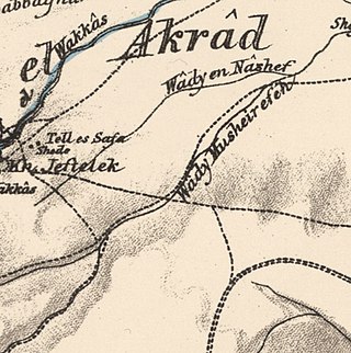
 1870s map
 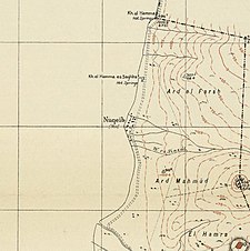 1940s map
 modern map
 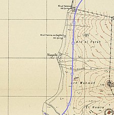 1940s with modern overlay map
