
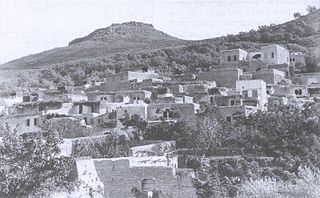
Mi'ar, was a Palestinian village located 17.5 kilometers east of Acre. Its population in 1945 was 770. The Crusaders referred to it as "Myary". By the 19th century, during Ottoman rule, it was a large Muslim village. The village was a center of Palestinian Arab rebel operations during the 1936–39 Arab revolt in Palestine against British rule and consequently the village was completely dynamited by the British. Mi'ar was later restored, but it was depopulated by Israeli forces during the 1948 Arab-Israeli War. The Jewish communities of Atzmon, Ya'ad and Manof are located on former village land.

Al-Mansura, was a Palestinian village that was depopulated by the Israeli army during the 1948 Arab-Israeli war. In 1945, it had a population of 2,300 together with the neighboring villages of Dayr al-Qassi and Fassuta. The population was predominantly Christian and most its residents live in what is now the state of Israel.
Hittin was a Palestinian village located 8 kilometers (5 mi) west of Tiberias before it was occupied by Israel during the 1948 Arab-Israeli war when most of its original residents became refugees after being ethnically cleansed. As the site of the Battle of Hattin in 1187, in which Saladin reconquered most of Palestine from the Crusaders, it has become an Arab nationalist symbol. The shrine of Nabi Shu'ayb, venerated by the Druze and Sunni Muslims as the tomb of Jethro, is on the village land. The village was ruled by the Ottoman Empire from the 16th century until the end of World War I, when Palestine became part of the British Mandate for Palestine. On July 17 1948, the village was occupied by Israel during the nakbaa, after its residents fled out of their homes because of Nazareth's occupation. in later years, the Moshavs Arbel and Kfar Zeitim were erected where Hittin used to be.

Ma'alul was a Palestinian village, with a mixed population of primarily Muslims with a substantial minority of Palestinian Christians, that was depopulated and destroyed by Israel during the 1948 Arab-Israeli war. Located six kilometers west of the city of Nazareth, many of its inhabitants became internally displaced refugees, after taking refuge in Nazareth and the neighbouring town of Yafa an-Naseriyye. Despite having never left the territory that came to form part of Israel, the majority of the villagers of Maalul, and other Palestinian villages like Andor and Al-Mujidal, were declared "absentees", allowing the confiscation of their land under the Absentees Property Law.
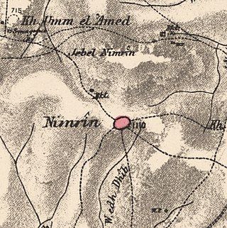
Nimrin was a Palestinian Arab town of 320 that was captured and depopulated by Israel during the 1948 Arab-Israeli War.

'Iraq Suwaydan was a Palestinian Arab village located 27 km (17 mi) northeast of Gaza City. It was captured by Israeli forces in Operation Yoav against the defending Egyptian Army during the 1948 Arab-Israeli War. The village infrastructure, with the exception of the police station built by the British Mandate authorities, was destroyed.

Ijzim was a Palestinian village in the Haifa Subdistrict of British Mandate Palestine, 19.5 kilometers south of Haifa, that was depopulated during the 1948 Arab-Israeli war. Many residents resettled in Jenin after Operation Shoter on 24 July 1948.
Bayt Jirja or Beit Jerja was a Palestinian Arab village 15.5 km Northeast of Gaza. In 1931 the village consisted of 115 houses. It was overrun by Israeli forces during operation Yo'av in the 1948 Arab-Israeli war. Bayt Jirja was found depopulated in November 1948, during "clean up sweeps" to expel any partial inhabited villages and destroy village housing to prevent any possible re-occupation in the area. The village was completely destroyed after the occupation and only one tomb remains.
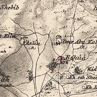
Islin was a Palestinian Arab village located 21 kilometers west of Jerusalem. The village had a population of 302 inhabitants and was depopulated during the 1948 Arab-Israeli war. It was occupied by Israeli forces, possibly from the Fourth Battalion of the Harel Brigade, on 18 July 1948 during Operation Dani, causing its inhabitants to leave. Eshtaol, a moshav, was built on the village's land.

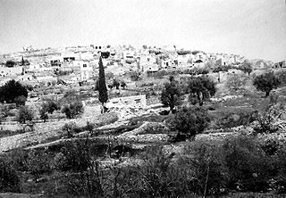
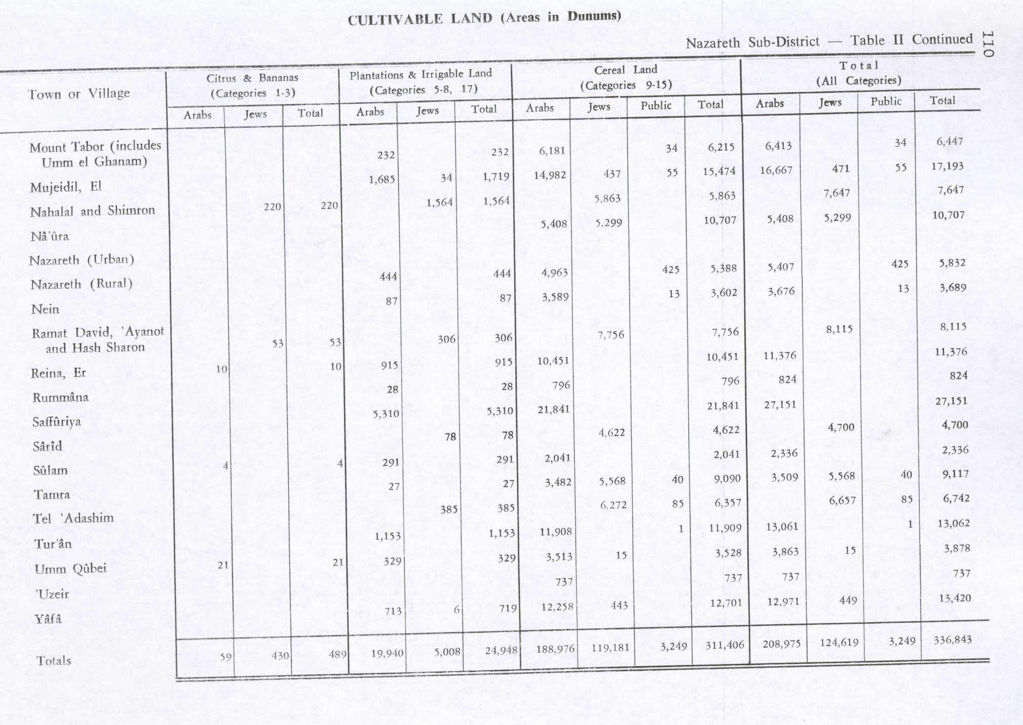
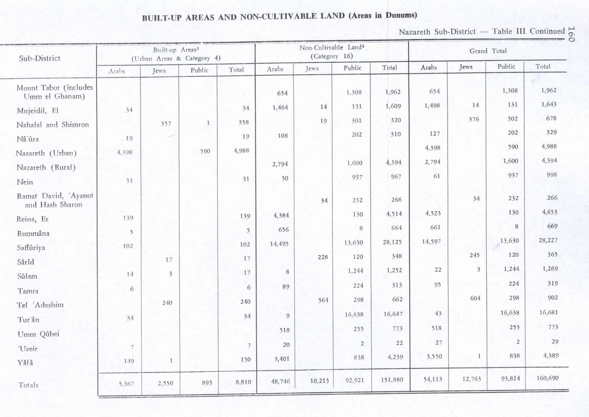
Indur was a Palestinian village, located 10.5 kilometres (6.5 mi) southeast of Nazareth. Its name preserves that of ancient Endor, a Canaanite city state thought to have been located 1 kilometre (0.62 mi) to the northeast. The village was depopulated during the 1948 Arab–Israeli War and its inhabitants became refugees, some of whom were internally displaced. In Israel today, there are a few thousand internally displaced Palestinians who hail from Indur, and continue to demand their right of return.

Ein al-Zeitun, was a Palestinian Arab village, located 1.5 kilometres (0.93 mi) north of Safed in the Upper Galilee. During the early Ottoman period, Ein el-Zeitun had a mixed population of Muslims and Jews. Later, in the 19th century, it became entirely Muslim. The village's small population and land area as well as its proximity to Safad made it a suburb of the city. In 1945, the village had a population of 820 inhabitants and a total land area of 1,100 dunams. The village was depopulated in 1948, after the Ein al-Zeitun massacre.

Al-Shajara was a Palestinian Arab village depopulated by Israel during the 1948 Arab-Israeli War when its residents were forcefully evacuated and became refugees. It was located 14 kilometers west of Tiberias on the main highway to Nazareth near the villages of Lubya and Hittin. The village was very close to the city of Nazareth, about 5 kilometers away.
Qalunya was a Palestinian village located 6 kilometers (3.7 mi) west of Jerusalem. Prior to the village's destruction in 1948, with the exception of 166 dunams, Qalunya's land was privately owned: 3,594 dunams were owned by Arabs, while 1,084 dunams were owned by Jews.

Al-Ja'una or Ja'ouna, was a Palestinian village situated in Galilee near al-Houleh Plateau, overlooking the Jordan Valley. The village lay on a hillside 450–500 meters above sea level, 5 kilometers east of Safad near a major road connecting Safad with Tabariya. The village had its Arab residents expelled by Zionist forces in 1948 and was thereafter resettled by Jews, becoming a part of the Israeli settlement of Rosh Pinna.
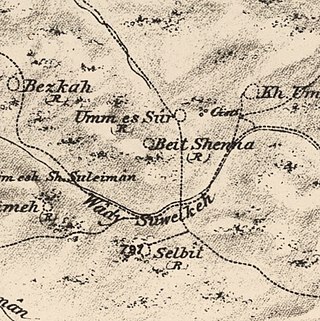
Bayt Shanna was a Palestinian Arab village in the Ramle Subdistrict of Mandatory Palestine. It was depopulated during the 1948 Arab–Israeli War on July 15, 1948, during the second stage of Operation Dani. It was located 11.5 km southeast of Ramla.
Arab al-Zubayd was a Palestinian village in the Safad Subdistrict. It was depopulated during the 1947–1948 Civil War in Mandatory Palestine on April 20, 1948, when the villagers fled on hearing the intentions of The Palmach's First Battalion of Operation Yiftach. It was located 15 km northeast of Safad, near the al-Mutilla-Safad—Tiberias highway.

Fara was a Palestinian Arab village in the Safad Subdistrict. It was depopulated during the 1948 Arab-Israeli War on October 30, 1948, under Operation Hiram. It was located 11.5 km north of Safad on the Wadi al-Fara.

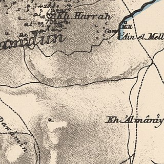
Al-'Ulmaniyya was a Palestinian Arab village in the Safad Subdistrict. It was depopulated during the 1947–1948 Civil War in Mandatory Palestine on April 20, 1948, by the Palmach's First Battalion of Operation Yiftach. It was located 14.5 km northeast of Safad.

Hadatha, also El Hadetheh or Hadateh, was a Palestinian Arab village in the District of Tiberias, located 12.5 km southwest of Tiberias. It was depopulated in the 1947–1948 civil war in Mandatory Palestine.

Ma'dhar was a Palestinian village in the Tiberias Subdistrict.
 1870s map
  1940s map
 modern map
  1940s with modern overlay map

