Al-Murassas

Last updated

Contents

Al-Murassas
المرصص
Etymology: the place of the rubble [1]
Historical map series for the area of al-Murassas (1870s).jpg 1870s map
Historical map series for the area of al-Murassas (1940s).jpg 1940s map
Historical map series for the area of al-Murassas (modern).jpg modern map
Historical map series for the area of al-Murassas (1940s with modern overlay).jpg 1940s with modern overlay map
A series of historical maps of the area around Al-Murassas (click the buttons)
Mandatory Palestine location map.svg
Red pog.svg
Al-Murassas
Location within Mandatory Palestine
Coordinates: 32°33′38″N35°28′25″E / 32.56056°N 35.47361°E / 32.56056; 35.47361
Palestine grid 195/218
Geopolitical entity Mandatory Palestine
Subdistrict Baysan
Date of depopulationMay 16, 1948 [2]
Population
 (1945)
  Total
460 [3] [4]
Cause(s) of depopulationInfluence of nearby town's fall

Al-Murassas (Arabic : المرصص), was a Palestinian Arab village in the District of Baysan. It was depopulated by the Israel Defense Forces during the 1948 War on May 16, 1948. The village was attacked as part of Operation Gideon.

History

In 1596 Al-Murassas was a farm paying taxes to the Ottoman authorities. [5]

Johann Ludwig Burckhardt mentions passing the village (which he called Meraszrasz) during his travels in the early 19th century. [6]

In 1838, el-Murussus was noted as part of the Jenin District. [7] [8]

In 1870/1871 (1288 AH), an Ottoman census listed the village in the nahiya (sub-district) of Shafa al-Shamali. [9]

In 1882 the PEF's Survey of Western Palestine (SWP) described the it as "A small village on high ground, entirely built of mud, and standing amid plough-land. The water supply appears to come from the valley beneath (Wady Yebla)." [10]

British Mandate era

In the 1922 census of Palestine, conducted by the Mandatory Palestine authorities, Murassas had a population of 319 Muslims, [11] increasing in the 1931 census to 381; 375 Muslims and 6 Christians, in a total of 89 houses. [12]

The village had a population of 460 in the 1945 statistics; 450 Muslims and 10 Christians, [3] while the total land area was 14,477 dunams. [4] Of this, Arabs used 16 dunums for plantations and irrigable land, 9,897 for cereals, [13] while 16 dunums were classified built–up (urban) land. [14]

1948, aftermath

On June 6, 1948, a platoon from the Israeli Barak brigade raided Danna, Al-Bira, Kafra, Yubla, Jabbul, and Al-Murassas. They would first fire "a few two-inch mortar rounds into its centre", then move in. Al-Murassas was found to be empty. [15] The destruction of Al-Murassas was later criticised by a veteran local Israeli leader, who thought that the villagers would have been willing to cooperate with the Yishuv and "allocate part of their lands for our settlements". [16]

In July, 1948, The Israeli kibbutz Beit HaShita took over 5,400 dunams of land from the newly depopulated Palestinian villages of Yubla and Al-Murassas. [17]

In 1992 the village site was described: "The village site is part of an agricultural area that is exploited by the settlements of Sde Nachum and Beyt ha-Shitta. The only structures on the area are telephone poles and a small shed. A small tell on the site, surrounded by plowed fields, is littered with rubble." [18]

Related Research Articles

<span class="mw-page-title-main">Al-Mansura, Acre</span> Village in Acre, Mandatory Palestine

Al-Mansura, was a Palestinian village that was depopulated by the Israeli army during the 1948 Arab-Israeli war. In 1945, it had a population of 2,300 together with the neighboring villages of Dayr al-Qassi and Fassuta. The population was predominantly Christian and most its residents live in what is now the state of Israel.

<span class="mw-page-title-main">Qumya</span> Village in Baysan, Mandatory Palestine

Qumya, was a Palestinian village of 510 inhabitants when it was depopulated prior to the 1948 Arab-Israeli war.

<span class="mw-page-title-main">Yubla</span> Village in Baysan, Mandatory Palestine

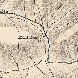
Yubla, was a Palestinian village, located 9 kilometers north of Bisan in present-day Israel. It was depopulated during the 1948 Arab-Israeli war.

<span class="mw-page-title-main">Sajad</span> Village in Ramle, Mandatory Palestine

Sajad was a Palestinian village in the Ramle Subdistrict. It was located sixteen kilometers south of Ramla. Sajad was established in the late 19th century near a local train station. It was depopulated during the 1948 Arab–Israeli war.

<span class="mw-page-title-main">Jabbul</span> Place in Baysan, Mandatory Palestine

Jabbul, is a depopulated former Palestinian Arab village located 7 km north of Baysan. During Operation Gideon, the village was occupied by the Golani Brigade.

<span class="mw-page-title-main">Al-Shajara, Palestine</span> Place in Tiberias, Mandatory Palestine

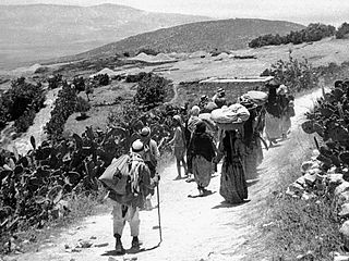
Al-Shajara was a Palestinian Arab village depopulated by Israel during the 1948 Arab-Israeli War when its residents were forcefully evacuated and became refugees. It was located 14 kilometers west of Tiberias on the main highway to Nazareth near the villages of Lubya and Hittin. The village was very close to the city of Nazareth, about 5 kilometers away.

<span class="mw-page-title-main">Shahma</span> Village in Ramle, Mandatory Palestine

Shahma was a Palestinian Arab village located 15 kilometers (9.3 mi) southwest of Ramla. Depopulated on the eve of the 1948 Arab-Israeli war, the village lands today form part of a fenced-in area used by the Israeli Air Force.

<span class="mw-page-title-main">Arab al-Bawati</span> Village in Baysan, Mandatory Palestine

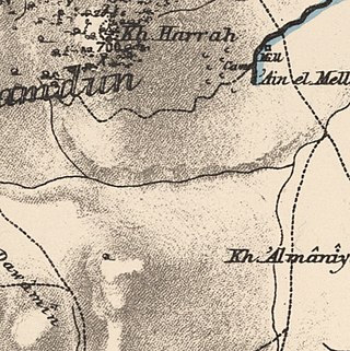
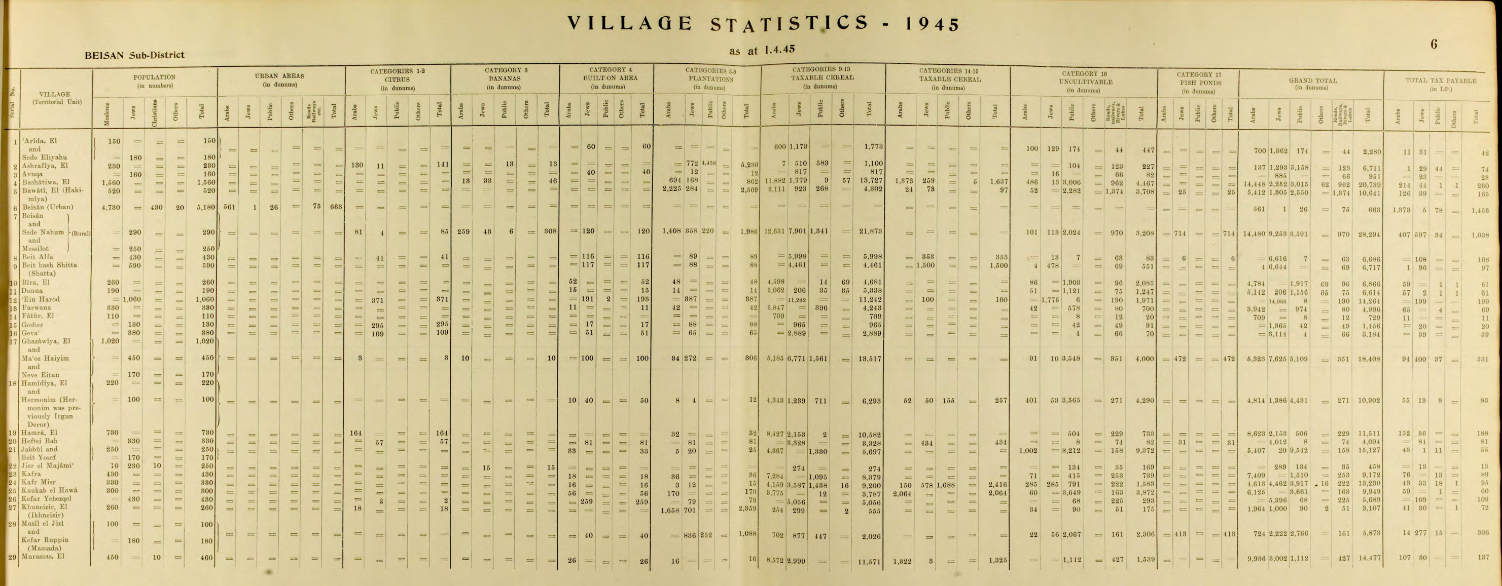
Arab al-Bawati, was a Palestinian Arab village in the District of Baysan. It was depopulated during the 1948 Arab-Israeli War.

<span class="mw-page-title-main">Tall al-Shawk</span> Village in Baysan, Mandatory Palestine

Tall al-Shawk, was a Palestinian village in the District of Baysan. It was depopulated by the Israel Defense Forces during the 1947–1948 Civil War in Mandatory Palestine on May 12, 1948, as part of Operation Gideon. It was located five km west of Baysan between the al-Januna'in River to the north and Wadi al-Jawsaq to the south. The village was built above an ancient archeological site and granite columns remain.

<span class="mw-page-title-main">Dayr Rafat</span> Village in Jerusalem, Mandatory Palestine

Dayr Rafat was a Palestinian Arab village in the Jerusalem Subdistrict. It was located 26 km west of Jerusalem. It was depopulated during the 1948 Arab–Israeli War by the Harel Brigade.

<span class="mw-page-title-main">Al-Haditha, Ramle</span> Place in Ramle, Mandatory Palestine

Al-Haditha was a Palestinian village in the Ramle Subdistrict. It was located 8 km northeast of Ramla, on the bank of Wadi al-Natuf. The site, now known as Tel Hadid, has yielded significant archaeological remains from many periods. Al-Haditha was depopulated during the 1948 Arab-Israeli War on July 12, 1948, under the first stage of Operation Dani.

<span class="mw-page-title-main">Jilya</span> Village in Ramle, Mandatory Palestine

Jilya was a Palestinian Arab village in the Ramle Subdistrict of Mandatory Palestine. The Romans referred to it as Jilya by Galla. It was depopulated during the 1948 Arab–Israeli War by the Givati Brigade of the first stage of Operation Dani on July 9, 1948. It was located 17 km south of Ramla.

<span class="mw-page-title-main">Al-Maghar</span> Place in Ramle, Mandatory Palestine

Al-Maghar was a Palestinian Arab village in the Ramle Subdistrict of Mandatory Palestine. It was depopulated by the Givati Brigade during Operation Barak on 18 May 1948. It was located 12 km southwest of Ramla, situated north of Wadi al-Maghar.

<span class="mw-page-title-main">Al-Mansura, Ramle</span> Village in Ramle, Mandatory Palestine

Al-Mansura was a small Palestinian Arab village in the Ramle Subdistrict, located 10 km south of Ramla. It was depopulated during the 1947–48 Civil War in Mandatory Palestine on April 20, 1948, under Operation Barak.

<span class="mw-page-title-main">Arab al-Shamalina</span> Place in Safad, Mandatory Palestine

Arab al-Shamalina also known as Khirbat Abu Zayna was a Palestinian Arab village in the Safad Subdistrict. It was depopulated during the 1947–1948 Civil War in Mandatory Palestine on May 4, 1948, under Operation Matate (Broom), a sub operation of Operation Yiftach. It was located 13 km southeast of Safad near the Jordan River.

<span class="mw-page-title-main">Arab al-Zubayd</span> Village in Safad subdistrict, Mandatory Palestine

Arab al-Zubayd was a Palestinian village in the Safad Subdistrict. It was depopulated during the 1947–1948 Civil War in Mandatory Palestine on April 20, 1948, when the villagers fled on hearing the intentions of The Palmach's First Battalion of Operation Yiftach. It was located 15 km northeast of Safad, near the al-Mutilla-Safad—Tiberias highway.

<span class="mw-page-title-main">Fara, Safad</span> Village in Safad, Mandatory Palestine

Fara was a Palestinian Arab village in the Safad Subdistrict. It was depopulated during the 1948 Arab-Israeli War on October 30, 1948, under Operation Hiram. It was located 11.5 km north of Safad on the Wadi al-Fara.

<span class="mw-page-title-main">Al-Zuq al-Tahtani</span> Village in Safad, Mandatory Palestine

Al-Zuq al-Tahtani was a Palestinian Arab village in the Safad Subdistrict. It was depopulated during the 1947–1948 Civil War in Mandatory Palestine on May 11, 1948, by the Palmach's First Battalion of Operation Yiftach. It was located 30 km northeast of Safad.

<span class="mw-page-title-main">Qaytiyya</span> Village in Safad, Mandatory Palestine

Qaytiyya was a Palestinian Arab village in the Safad Subdistrict. It was depopulated during the 1948 War on May 19, 1948, by the Palmach's First Battalion of Operation Yiftach. It was located 28 km northeast of Safad, bordering both the Hasibani and the Dan Rivers.

<span class="mw-page-title-main">Al-Samakiyya</span> Village in Tiberias, Mandatory Palestine

Al-Samakiyya was a Palestinian Arab village in the Tiberias Subdistrict. It was depopulated during the 1947–1948 Civil War in Mandatory Palestine on May 4, 1948, under Operation Matateh. It was located 11 km northeast of Tiberias, near the Wadi al-Wadabani. The village was located at Tel Hum, which has been identified with Capernaum.

References

  1. Palmer, 1881, p. 166
  2. Morris, 2004, p. xvii, village #117. Also gives cause of depopulation.
  3. 1 2 Department of Statistics, 1945, p. 6
  4. 1 2 Government of Palestine, Department of Statistics. Village Statistics, April, 1945. Quoted in Hadawi, 1970, p. 43
  5. Al-Bakhit and al-Hamud, 1989, p. 17; cited in Khalidi, 1992, p. 56
  6. Burckhardt, 1822, pp. 342-343
  7. Robinson and Smith, 1841, vol 3, p. 218
  8. Robinson and Smith, 1841, vol 3, 2nd Appendix, p. 130
  9. Grossman, David (2004). Arab Demography and Early Jewish Settlement in Palestine. Jerusalem: Magnes Press. p. 256.
  10. Conder and Kitchener, 1882, SWP II, p. 85
  11. Barron, 1923, Table IX, p. 31
  12. Mills, 1932, p. 79
  13. Government of Palestine, Department of Statistics. Village Statistics, April, 1945. Quoted in Hadawi, 1970, p. 85
  14. Government of Palestine, Department of Statistics. Village Statistics, April, 1945. Quoted in Hadawi, 1970, p. 135
  15. Morris, 2004, pp. 261-262, 308
  16. Morris, 2004, p. 357
  17. Fischbach, 2012, p. 13
  18. Khalidi, 1992, pp. 56-57

Bibliography