Miska, Tulkarm

Last updated
Miska
مسكة
Village
RuinsInMiska.JPG
Remains of the village mosque, 2007
Etymology: The water-hole [1]
Historical map series for the area of Miska, Tulkarm (1870s).jpg 1870s map
Historical map series for the area of Miska, Tulkarm (1940s).jpg 1940s map
Historical map series for the area of Miska, Tulkarm (modern).jpg modern map
Historical map series for the area of Miska, Tulkarm (1940s with modern overlay).jpg 1940s with modern overlay map
A series of historical maps of the area around Miska, Tulkarm (click the buttons)
Mandatory Palestine location map.svg
Red pog.svg
Miska
Location within Mandatory Palestine
Coordinates: 32°13′04″N34°55′29″E / 32.21778°N 34.92472°E / 32.21778; 34.92472
Palestine grid 143/180
Geopolitical entity Mandatory Palestine
Subdistrict Tulkarm
Date of depopulation15 April 1948 [2] [3]
Area
  Total8,076  dunams (8.076 km2 or 3.118 sq mi)
Population
 (1948)
  Total880 [4] [5]
Cause(s) of depopulationExpulsion by Yishuv forces
Current Localities Sde Warburg, Mishmeret [6]

Miska was a Palestinian village, located fifteen kilometers southwest of Tulkarm, depopulated in 1948.

Contents

History

Miska was founded by descendants of the Arabian tribe of Miskain during the 7th century Islamic conquest of Palestine. [7]

According to the Arab geographer Yaqut, writing in the 1220s, Miska was known for its fruit, especially the misk (musk) apple variety which was said to have been transferred to Egypt by the Fatimid vizier Abu Muhammad al-Yazuri, who died in 1058. [8]

Ottoman era

The French commander Jean Baptiste Kléber and his troops passed by the village on their way to Napoleon's siege of Acre in 1799. [9] Pierre Jacotin named the village Meski on his map from the same campaign. [10]

In the 1860s, the Ottoman authorities granted the village an agricultural plot of land called Ghabat Miska in the former confines of the Forest of Arsur (Ar. Al-Ghaba) in the coastal plain, west of the village. [11] [12]

In 1870, Victor Guérin visited and estimated that the population of Miskeh was 300. He further noted that "In the court of the medhafeh (guest-house) I saw a column and a marble chapter, apparently of Byzantine work. Round the houses are gardens, planted principally with fig-trees, among which here and there rise palms." [13]

In 1870/1871 (1288 AH), an Ottoman census listed the village in the nahiya (sub-district) of Bani Sa'b. [14]

In 1882, the PEF's Survey of Western Palestine (SWP) described Miska an adobe village of small size, with olives to the north and south, and a well to the south. [15]

British Mandate era

In the 1922 census of Palestine conducted by the British Mandate authorities, Meskeh had a population of 443; all Muslims, [16] increasing in the 1931 census to 635, still all Muslim, in a total of 123 houses. [17]

In the 1945 statistics the population of Miska and Sde Warburg was 880 Arabs and 180 Jews, [4] while the total land area was 8,076 dunams, according to an official land and population survey. [5] Of this, Arabs used 1,115 dunams for citrus and bananas, 304 dunams for plantations and irrigable land, 3,245 for cereals, [18] while 88 dunams were classified as built-up areas. [19]

Miska (Miske) 1942 1:20,000 Et Tire 1942.jpg
Miska (Miske) 1942 1:20,000
Miska 1945 1:250,000 Qalqilya 1945.jpg
Miska 1945 1:250,000

1948 and after

On 15 April 1948, Miska's Arab inhabitants were expelled on the order of the Haganah, the primary Jewish force prior to the outbreak of the 1948 Arab–Israeli War. [2] The village, with the exception of a boy's elementary school and a mosque, was destroyed on the orders of Yosef Weitz, a Jewish National Fund official. [7]

On 16 June 1948, David Ben-Gurion, almost certainly based on a progress report from Yosef Weitz, noted Miska as one of the Palestinian villages that they had destroyed. [20]

Sde Warburg was established in 1938 on land that traditionally belonged to the village. Mishmeret was established in 1946, to the northwest of the village site, on village land. Ramat HaKovesh, founded 1932, is about 1 km due west of the village site, though not on village land. [6]

The Palestinian historian Walid Khalidi described the village in 1992: "The site is covered with citrus groves; cactuses grow along the perimeter of these groves. The two-room school still stands and is used as housing for the watchmen who guard the orchards. The mosque serves as a storehouse for bales of hay and agricultural tools. The large cement fragments of a demolished enclosure built around the village well are visible. Most of the surrounding land has been planted by Israelis with citrus trees." [21]

The school buildings were destroyed by order of the Israel Land Administration in 2006 following commemoration activities at the site organised by Palestinian Citizens of Israel and Israeli NGO Zochrot. [22] [23]

See also

Related Research Articles

<span class="mw-page-title-main">Al-Nabi Rubin, Acre</span> Place in Acre, Mandatory Palestine

Al-Nabi Rubin, was a Palestinian village located 28 kilometers northeast of Acre. Al-Nabi Rubin students used to attend school in the nearby village of Tarbikha.

<span class="mw-page-title-main">Suruh</span> Village in Acre, Mandatory Palestine

Suruh, was a Palestinian Arab hamlet, located 28.5 kilometers (17.7 mi) northeast of Acre. It became depopulated in the 1948 Arab-Israeli war.

<span class="mw-page-title-main">Khirbat Zalafa</span> Place in Tulkarm, Mandatory Palestine

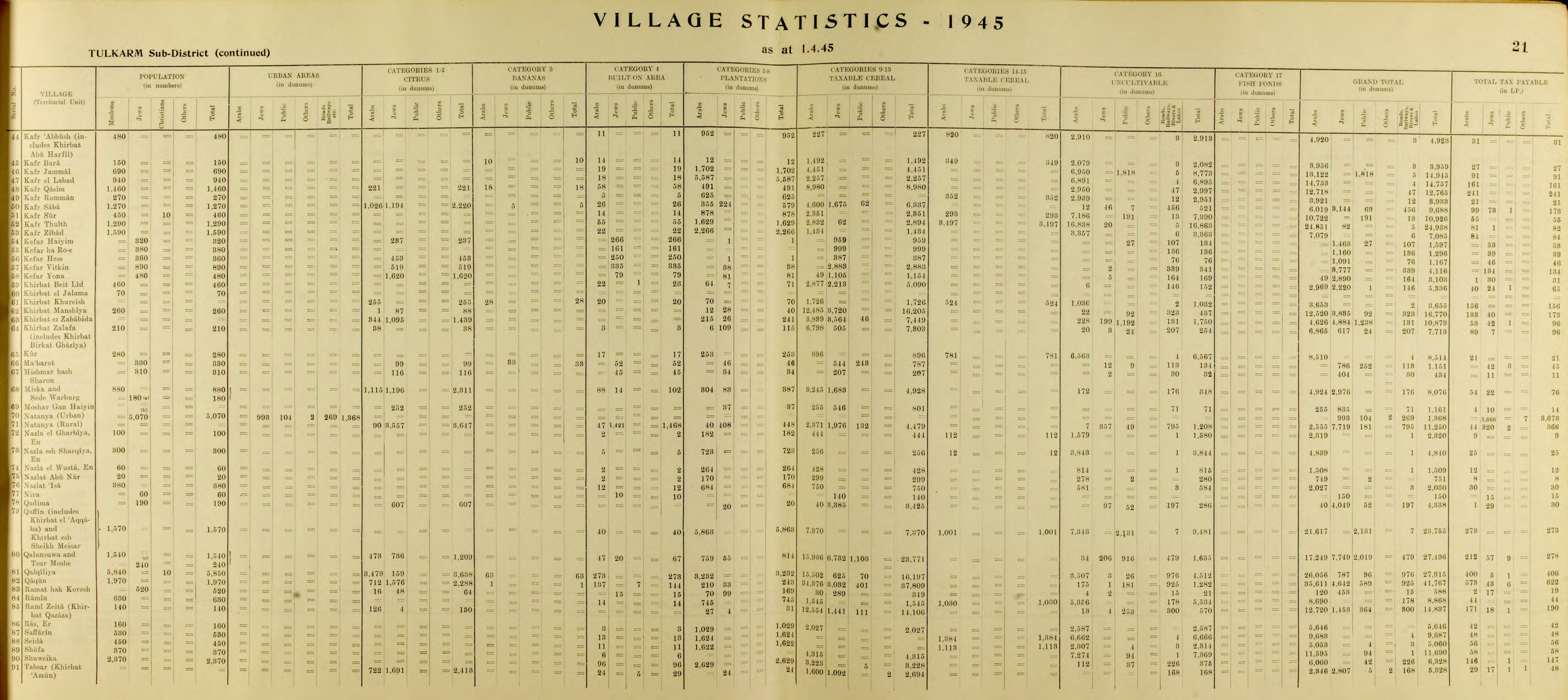
Khirbat Zalafa was a small Palestinian Arab village in the Tulkarm Subdistrict, located about 15 kilometers (9.3 mi) northwest of Tulkarm. It was depopulated during the 1948 Palestine war. It was occupied by Yishuv forces on April 15, 1948 as a part of operation "Coastal Clearing."

<span class="mw-page-title-main">Lazzaza</span> Village in Safad, Mandatory Palestine

Lazzaza was a Palestinian Arab village of 230 in the northern Hula Valley next to the Hasbani River, located 27.5 kilometers (17.1 mi) northwest of Safad. Beit Hillel subsequently expanded onto the land.

<span class="mw-page-title-main">Arab al-Bawati</span> Village in Baysan, Mandatory Palestine

Arab al-Bawati, was a Palestinian Arab village in the District of Baysan. It was depopulated during the 1948 Arab-Israeli War.

<span class="mw-page-title-main">Tall al-Shawk</span> Village in Baysan, Mandatory Palestine

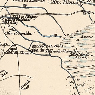
Tall al-Shawk, was a Palestinian village in the District of Baysan. It was depopulated by the Israel Defense Forces during the 1947–1948 Civil War in Mandatory Palestine on May 12, 1948, as part of Operation Gideon. It was located five km west of Baysan between the al-Januna'in River to the north and Wadi al-Jawsaq to the south. The village was built above an ancient archeological site and granite columns remain.

<span class="mw-page-title-main">Arab al-Fuqara</span> Place in Haifa, Mandatory Palestine

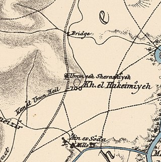
Arab al-Fuqara was a Palestinian Arab village in the Haifa Subdistrict. It was depopulated during the 1947–1948 Civil War in Mandatory Palestine on April 10, 1948. At that time, the land records of the village consisted of a total area of 2,714 dunams, of which 2,513 were owned by Jews, 15 owned by Arabs, and the remaining 186 dunams being public lands.

<span class="mw-page-title-main">Khubbayza</span> Village in Haifa, Mandatory Palestine

Khubbayza was a Palestinian Arab village in the Haifa Subdistrict, located 29.5 kilometers (18.3 mi) southeast of Haifa. It was situated on hilly terrain, south of Wadi al-Sindiyana, between the Jezreel Valley with the Mediterranean coast. In 1945, it had a population of 290. Khubbayza was depopulated during the 1948 War on May 12, 1948, in the Battle of Mishmar HaEmek.

<span class="mw-page-title-main">Bayt Umm al-Mays</span> Place in Jerusalem, Mandatory Palestine

Bayt Umm al-Mays was a small Palestinian Arab village in the Jerusalem Subdistrict. It was depopulated during the 1948 Arab-Israeli War on October 21, 1948, by the Har'el Brigade of Operation ha-Har. It was located 14 km west of Jerusalem.

<span class="mw-page-title-main">Dayr Rafat</span> Village in Jerusalem, Mandatory Palestine

Dayr Rafat was a Palestinian Arab village in the Jerusalem Subdistrict. It was located 26 km west of Jerusalem. It was depopulated during the 1948 Arab–Israeli War by the Harel Brigade.

<span class="mw-page-title-main">Khirbat Ism Allah</span> Village in Jerusalem, Mandatory Palestine

Khirbat Ism Allah was a Palestinian Arab hamlet in the Jerusalem Subdistrict, located 26 km west of Jerusalem. It was depopulated during the 1948 Arab–Israeli War on July 17, 1948, by the Harel Brigade of Operation Dani. Khirbat Ism Allah was mostly destroyed with the exception of several deserted houses.

<span class="mw-page-title-main">Ayn al-Mansi</span> Place in Jenin, Mandatory Palestine

Ayn al-Mansi was a Palestinian Arab village in the District of Jenin of the Mandatory Palestine. It was depopulated as a result of a military attack in mid-April during the 1947–48 Civil War in Mandatory Palestine.

<span class="mw-page-title-main">Dayr Abu Salama</span> Village in Ramle, Mandatory Palestine

Dayr Abu Salama was a small Palestinian Arab village in the Ramle Subdistrict, located 8 km northeast of Ramla. It was depopulated during the 1948 Arab–Israeli War on July 13, 1948, in the first phase of Operation Dani.

<span class="mw-page-title-main">Dayr Muhaysin</span> Place in Ramle, Mandatory Palestine

Dayr Muhaysin was a Palestinian village in the Ramle Subdistrict of Mandatory Palestine, located 12 km southeast of Ramla and 4 km west of Latrun. It was depopulated during the 1948 Palestine war.

<span class="mw-page-title-main">Al-Kunayyisa</span> Place in Ramle, Mandatory Palestine

Al-Kunayyisa was a small Palestinian Arab village in the Ramle Subdistrict. It was depopulated during the 1948 Arab–Israeli War on July 10, 1948, under the first stage of Operation Dani. It was located 12 km southeast of Ramla.

<span class="mw-page-title-main">Arab al-Shamalina</span> Place in Safad, Mandatory Palestine

Arab al-Shamalina also known as Khirbat Abu Zayna was a Palestinian Arab village in the Safad Subdistrict. It was depopulated during the 1947–1948 Civil War in Mandatory Palestine on May 4, 1948, under Operation Matate (Broom), a sub operation of Operation Yiftach. It was located 13 km southeast of Safad near the Jordan River.

<span class="mw-page-title-main">Ghabbatiyya</span> Village in Safad, Mandatory Palestine

Ghabbatiyya was a Palestinian Arab hamlet in the Safad Subdistrict. It was depopulated during the 1948 Arab-Israeli War on October 30, 1948, under Operation Hiram. It was located 12 km northwest of Safad.

<span class="mw-page-title-main">Al-Sanbariyya</span> Place in Safad, Mandatory Palestine

Al-Sanbariyya was a Palestinian village in the Safad Subdistrict. It was depopulated during the 1947–1948 Civil War in Mandatory Palestine on May 1, 1948, by Palmach's First Battalion under Operation Yiftach. It was located 31.5 km northeast of Safad, near Wadi Hasibani.

<span class="mw-page-title-main">Ghuwayr Abu Shusha</span> Place in Tiberias, Mandatory Palestine

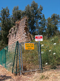
Ghuwayr Abu Shusha was a Palestinian Arab village in the Tiberias Subdistrict. It was depopulated during the 1947–1948 Civil War in Mandatory Palestine on April 21, 1948. It was located 8 km north of Tiberias, nearby Wadi Rubadiyya.

<span class="mw-page-title-main">Khirbat al-Zababida</span> Place in Tulkarm, Mandatory Palestine

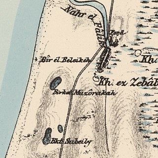
Khirbat al-Zababida was a Palestinian Arab village in the Tulkarm Subdistrict. It was depopulated during the 1948 Arab–Israeli War on May 15, 1948. It was located 20 kilometres (12 mi) southwest of Tulkarm, south of Wadi al-Faliq. Khirbat al-Zababida was mostly destroyed except for four deserted houses.

References

  1. Palmer, 1881, p. 175
  2. 1 2 Pappe, 1999, pp. 204, 209
  3. Morris, 2004, p. xviii, village #191. Also gives cause of depopulation
  4. 1 2 Department of Statistics, 1945, p. 21
  5. 1 2 Government of Palestine, Department of Statistics. Village Statistics, April, 1945. Quoted in Hadawi, 1970, p. 76
  6. 1 2 Khalidi, 1992, p. 558
  7. 1 2 "Welcome to Miska". Palestine Remembered. Retrieved 2007-12-09.
  8. Mu'jam Al-Buldan, Cited in Khalidi, 1992, p. 558
  9. Nelson: Napoleon in Egypt. Cited in Khalidi, 1992, p. 558
  10. Karmon, 1960, p. 170
  11. Marom, Roy, "The Contribution of Conder's Tent Work in Palestine for the Understanding of Shifting Geographical, Social and Legal Realities in the Sharon during the Late Ottoman Period", in Gurevich D. and Kidron, A. (eds.), Exploring the Holy Land: 150 Years of the Palestine Exploration Fund, Sheffield, UK, Equinox (2019), pp. 212-231
  12. Marom, Roy (2022). "The Oak Forest of the Sharon (al-Ghaba) in the Ottoman Period: New Insights from Historical- Geographical Studies, Muse 5,". escholarship.org. Retrieved 2023-10-06.
  13. Guérin, 1875 pp. 388–389, as given by Conder and Kitchener, 1882, SWP II, p. 135
  14. Grossman, David (2004). Arab Demography and Early Jewish Settlement in Palestine. Jerusalem: Magnes Press. p. 255.
  15. Conder and Kitchener, 1882, SWP II, p. 135. Cited in Khalidi, 1992, p. 558
  16. Barron, 1923, Table IX, Sub-district of Tulkarem, p. 28
  17. Mills, 1932, p. 55
  18. Government of Palestine, Department of Statistics. Village Statistics, April, 1945. Quoted in Hadawi, 1970, p. 126
  19. Government of Palestine, Department of Statistics. Village Statistics, April, 1945. Quoted in Hadawi, 1970, p. 176
  20. Entry for 16 June 1948, DBG-YH II, 523–24. Cited in Morris, 2004, pp. 350, 398
  21. Khalidi, 1992, pp. 558–9
  22. Destroyed Miske Schoolhouse [Usurped!], by Zochrot. Retrieved 13 May 2010.
  23. Letter from District Manager's Bureau of ILA [Usurped!], published by Zochrot (30 August 2006). Retrieved 13 May 2010.

Bibliography