Demilitarized zone

Last updated

The Vietnamese Demilitarized Zone separating North and South Vietnam in 1969 DMZ1.jpg
The Vietnamese Demilitarized Zone separating North and South Vietnam in 1969

A demilitarized zone (DMZ or DZ) [1] is an area in which treaties or agreements between states, military powers or contending groups forbid military installations, activities, or personnel. A DZ often lies along an established frontier or boundary between two or more military powers or alliances. A DZ may sometimes form a de facto international border, such as the Korean Demilitarized Zone. Other examples of demilitarized zones are a 14 km (8.7 mi) wide area between Iraq and Kuwait; Antarctica (preserved for scientific exploration and study); and outer space (space more than 100 km or 62 mi from the Earth's surface).

Contents

Many demilitarized zones are considered neutral territory because neither side is allowed to control it, even for non-combat administration.[ dubious ] Some zones remain demilitarized after an agreement has awarded control to a state which (under the DZ terms) had originally ceded its right to maintain military forces in the disputed territory. It is also possible for powers to agree on the demilitarization of a zone without formally settling their respective territorial claims, enabling the dispute to be resolved by peaceful means such as diplomatic dialogue or an international court.

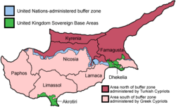
Several demilitarized zones have also unintentionally become wildlife preserves because their land is unsafe for construction or less exposed to human disturbances (including hunting). Examples include the Korean Demilitarized Zone, the Cypriot Demilitarized Zone (The Green Line), and the former Vietnamese Demilitarized Zone which divided Vietnam into two countries (North Vietnam and South Vietnam) from 21 July 1954 to 2 July 1976.

Current demilitarized zones

Former demilitarized zones

Historical map of the promontory of Gibraltar. Gibraltar map.png
Historical map of the promontory of Gibraltar.

See also

Related Research Articles

<span class="mw-page-title-main">United Nations Truce Supervision Organization</span> UN peacekeeping mission in the Middle East

The United Nations Truce Supervision Organization (UNTSO) is an organization founded on 29 May 1948 for peacekeeping in the Middle East. Established amidst the 1948 Arab–Israeli War, its primary task was initially to provide the military command structure to the peacekeeping forces in the Middle East to enable the peacekeepers to observe and maintain the ceasefire, and in assisting the parties to the Armistice Agreements in the supervision of the application and observance of the terms of those Agreements. The organization's structure and role has evolved over time as a result of the various conflicts in the region and at times UNTSO personnel have been used to rapidly deploy to other areas of the Middle East in support of other United Nations operations. The command structure of the UNTSO was maintained to cover the later peacekeeping organisations of the United Nations Disengagement Observer Force (UNDOF) and the United Nations Interim Force in Lebanon (UNIFIL) to which UNTSO continues to provide military observers.

<span class="mw-page-title-main">1949 Armistice Agreements</span> Formal ceasefire which ended the 1948 Arab–Israeli War

The 1949 Armistice Agreements were signed between Israel and Egypt, Lebanon, Jordan, and Syria. They formally ended the hostilities of the 1948 Arab–Israeli War and also demarcated the Green Line, which separated Arab-controlled territory from Israel until the latter's victory in the 1967 Arab–Israeli War.

<span class="mw-page-title-main">Egypt–Israel peace treaty</span> 1979 peace treaty between Egypt and Israel

The Egypt–Israel peace treaty was signed in Washington, D.C., United States, on 26 March 1979, following the 1978 Camp David Accords. The Egypt–Israel treaty was signed by Anwar Sadat, President of Egypt, and Menachem Begin, Prime Minister of Israel, and witnessed by Jimmy Carter, President of the United States.

<span class="mw-page-title-main">Korean Demilitarized Zone</span> North-South Korean border barrier

The Korean Demilitarized Zone is a strip of land running across the Korean Peninsula near the 38th parallel north. The demilitarized zone (DMZ) is a border barrier that divides the peninsula roughly in half. It was established to serve as a buffer zone between the countries of North Korea and South Korea under the provisions of the Korean Armistice Agreement in 1953, an agreement between North Korea, China, and the United Nations Command.

<span class="mw-page-title-main">Military Demarcation Line</span> Land border between North and South Korea

The Military Demarcation Line (MDL), sometimes referred to as the Armistice Line, is the land border or demarcation line between North Korea and South Korea. On either side of the line is the Korean Demilitarized Zone (DMZ). The MDL and DMZ were established by the Korean Armistice Agreement.

<span class="mw-page-title-main">Ceasefire</span> Temporary agreement to stop a war

A ceasefire, also spelled cease fire, is a stoppage of a war in which each side agrees with the other to suspend aggressive actions, often due to mediation by a third party. Ceasefires may be between state actors or involve non-state actors.

<span class="mw-page-title-main">Philadelphi Corridor</span> Strip of land on the Egypt-Gaza border

The Philadelphi Corridor, also called Philadelphi Route or Saladin Axis, is the Israeli code name for a narrow strip of land, 14 km in length, situated along the entirety of the border between Gaza Strip and Egypt.

<span class="mw-page-title-main">Vietnamese Demilitarized Zone</span> Demarcation line separating North Vietnam and South Vietnam (1954–1976)

The Vietnamese Demilitarized Zone was a demilitarized zone at the 17th parallel in Quang Tri province that was established as the dividing line between the two countries i.e. North Vietnam and South Vietnam from 22 July 1954 to 2 July 1976 when Vietnam was officially divided into the two military gathering areas, which was intended to be sustained in the short term after the First Indochina War.

<span class="mw-page-title-main">Purple Line (ceasefire line)</span> De facto border between Israel and Syria since the 1967 Six-Day War

The Purple Line was the ceasefire line between Israel and Syria after the 1967 Six-Day War and serves as the de facto border between the two countries.

An international zone is any area not fully subject to the border control policies of the state in which it is located. There are several types of international zones ranging from special economic zones and sterile zones at ports of entry exempt from customs rules to concessions over which administration is ceded to one or more foreign states. International zones may also maintain distinct visa policies from the rest of the surrounding state.

<span class="mw-page-title-main">United Nations Disengagement Observer Force</span> Peacekeeping mission overseeing Israeli–Syrian ceasefire

The United Nations Disengagement Observer Force (UNDOF) is a United Nations peacekeeping mission tasked with maintaining the ceasefire between Israel and Syria in the aftermath of the 1973 Yom Kippur War. The mission was established by United Nations Security Council Resolution 350 on 31 May 1974, to implement Resolution 338 (1973) which called for an immediate ceasefire and implementation of United Nations Security Council Resolution 242.

<span class="mw-page-title-main">Borders of Israel</span> Political boundaries between Israel and neighboring states

The modern borders of Israel exist as the result both of past wars and of diplomatic agreements between the State of Israel and its neighbours, as well as an effect of the agreements among colonial powers ruling in the region before Israel's creation. Only two of Israel's five total potential land borders are internationally recognized and uncontested, while the other three remain disputed; the majority of its border disputes are rooted in territorial changes that came about as a result of the 1967 Arab–Israeli War, which saw Israel occupy large swathes of territory from its rivals. Israel's two formally recognized and confirmed borders exist with Egypt and Jordan since the 1979 Egypt–Israel peace treaty and the 1994 Israel–Jordan peace treaty, while its borders with Syria, Lebanon and the Palestinian territories remain internationally defined as contested.

A political demarcation line is a geopolitical border, often agreed upon as part of an armistice or ceasefire.

<span class="mw-page-title-main">Israel–Syria Mixed Armistice Commission</span> Commission overseeing Israeli–Syrian ceasefire after the 1948 Arab-Israeli war

The Israel–Syria Mixed Armistice Commission (ISMAC) was the United Nations commission for observing the armistice between Israel and Syria after the 1948 Arab–Israeli War, as part of the Mixed Armistice Commissions (MAC). The fourth and last truce agreement, the 1949 armistice agreement, was signed between Israel and Syria on 20 July 1949 on Hill 232 near Mahanayim, ending the formal conflict in the former Mandatory Palestine. The Israeli side was represented by Lieutenant Colonel Mordechai Maklef, Yehoshua Penman and Shabtai Rosenne, while the Syrian side was represented by Colonel Fawzi Selo, Lieutenant Colonel Mohamed Nasser and Captain Afif Sizri. While the armistice agreements with Syria concluded the 1948 Arab–Israeli War, they did not mark the end of the Arab–Israeli conflict.

<span class="mw-page-title-main">Auja al-Hafir</span> Ottoman outpost and Palestinian village

Auja al-Hafir was an ancient road junction close to water wells in the western Negev and eastern Sinai. It was the traditional grazing land of the 'Azazme tribe. The border crossing between Egypt and Ottoman/British Palestine, about 60 km (37 mi) south of Gaza, was situated there. Today it is the site of Nitzana and the Ktzi'ot prison in the Southern District of Israel.

<span class="mw-page-title-main">Israeli Military Governorate</span> Military governance system (1967–1981/82)

The Israeli Military Governorate was a military governance system established following the Six-Day War in June 1967, in order to govern the civilian population of the West Bank, the Gaza Strip, the Sinai Peninsula and the western part of Golan Heights. The governance was based on the Fourth Geneva Convention, which provides guidelines for military rule in occupied areas. East Jerusalem was the only exception from this order, and it was added to Jerusalem municipal area as early as 1967, and extending Israeli law to the area effectively annexing it in 1980. During this period, the UN and many sources referred to the military governed areas as Occupied Arab Territories.

<span class="mw-page-title-main">Safe Zone (Syria)</span> Syria war 2011

Safe zones, de-escalation zones or no-fly zones have been proposed or created at various points during the Syrian civil war which began in 2011, including "de-escalation zones" agreed between the Turkish and Russian powers backing various belligerent parties and no-fly zones proposed in the Kurdish Northeast and rebel Northwest of the country.

<span class="mw-page-title-main">Israeli occupation of the Sinai Peninsula</span> Part of the Arab–Israeli conflict

The Sinai Peninsula, which is a part of Egypt, has been militarily occupied by Israel twice since the beginning of the Arab–Israeli conflict: the first occupation lasted from October 1956 to March 1957, and the second occupation lasted from June 1967 to April 1982. Israel initially seized the Sinai Peninsula during the Suez Crisis, when it attacked Egypt in response to the Egyptian blockade against all Israeli shipping; the Egyptians had been contesting Israel's freedom of navigation through the Straits of Tiran and the Suez Canal since 1949, impacting the country's ability to import and export goods during the Israeli austerity period. Although the occupation allowed Israel to re-open the Straits of Tiran, the Suez Canal was closed until 1957, when Israeli troops withdrew from Egypt. In the mid-1960s, amidst warnings from Israeli officials that another blockade would be a casus belli, Egypt re-imposed the blockade against Israel and subsequently lost the Sinai Peninsula in the 1967 Arab–Israeli War. Like before, Israel's occupation allowed it to re-open the Straits of Tiran, but, once again, the Suez Canal was closed until 1975. For the next three years, Egypt, seeking to regain the territory it had lost, launched the unsuccessful War of Attrition against Israel. Later, a large-scale Egyptian military offensive against Israel, known as Operation Badr, triggered the 1973 Arab–Israeli War, which ended with the Israelis retaining control of the Sinai Peninsula. By 1979, the United States had successfully negotiated the Egypt–Israel peace treaty: the Egyptians recognized Israel as a sovereign state, recognized the Straits of Tiran and the Gulf of Aqaba as international waterways, and agreed to demilitarize along Israel's border. In exchange, Israel agreed to withdraw all civilians and soldiers from the Sinai Peninsula and return it to Egypt. On 25 April 1982, Israel's withdrawal concluded and Egypt has since left the Sinai Peninsula demilitarized, marking the first instance of peace between Israel and an Arab country.

<span class="mw-page-title-main">Northern Syria Buffer Zone</span> Demilitarized zone in Syria

The Northern Syria Buffer Zone was a temporary Syrian Civil War demilitarized zone (DMZ) established on the Syrian side of the Syria–Turkey border in August 2019 to maintain security along the border and to dissuade a prospective Turkish invasion of the self-proclaimed Autonomous Administration of North and East Syria. The DMZ was administered by the Kurdish-led Syrian Democratic Forces (SDF) and their military councils and enforced by United States Armed Forces and Turkish Armed Forces personnel.

References

  1. Oren, Michael (3 June 2003). Six Days of War: June 1967 and the Making of the Modern Middle East. Presidio Press. p. 7. ISBN   978-0345461926.
  2. "art. 1", Antarctic Treaty , 1959
  3. "art. 1", Korean Armistice Agreement , 1953
  4. Walker, Philip (24 June 2011). "The world's most dangerous borders". Foreign Policy. Archived from the original on 8 March 2017.
  5. "Request for Interpretation of the Judgment of 15 June 1962 in the Case concerning the Temple of Preah Vihear (Cambodia v. Thailand)" (PDF). International Court of Justice . 18 July 2011. Archived from the original (PDF) on 17 October 2013. Retrieved 9 October 2018.
  6. Camp David Accords – Israeli Ministry of Foreign Affairs Archived 3 September 2011 at the Wayback Machine
  7. 10 Tactical Air Group: Canadian Contingent Multinational Force and Observers Handbook (unclassified), page A-1. DND, Ottawa, 1986.
  8. Keinon, Herb (9 August 2012). "Israel OKs Egypt attack helicopters in Sinai". Jerusalem Post.
  9. Issacharoff, Avi (16 August 2012). "Egypt deployed troops in Sinai without Israel's prior approval". Haaretz. Retrieved 24 August 2012.
  10. Keinon, Herb (21 August 2012). "Int'l force in Sinai quiet amid concern of violations". Jerusalem Post. Retrieved 29 October 2013.
  11. "Israel approves Egypt's request to increase forces in Sinai". Jerusalem Post. 15 July 2013.
  12. "Sudan agrees demilitarised zone for north-south border". BBC News . BBC. 31 May 2011. Retrieved 24 October 2015.
  13. Ahmed, Amir; Botelho, Greg (9 March 2013). "Sudan, South Sudan agree to pull troops from demilitarized zone". Cable News Network . Turner Broadcasting System, Inc. Retrieved 24 October 2015.
  14. "Palestine Maps" (PDF). Palestinian Academic Society for the Study of International Affairs . Archived from the original (PDF) on 15 February 2006. Retrieved 9 October 2018.
  15. Estudio de la cuestión de límites entre el Perú y el Ecuador (in Spanish). Peru: Ministry of War of Peru. 1961. pp. 71–72.
  16. Kurdistan24. "US and Turkey reach accord, but concerns of Syrian Kurds continue". Kurdistan24. Retrieved 25 August 2019.{{cite web}}: CS1 maint: numeric names: authors list (link)
  17. Pitarakis, Lefteris; Mroue, Bassem. "Turkey launches assault on Kurdish fighters in Syria, after US forces step aside". www.timesofisrael.com. Retrieved 9 October 2019.
  18. "Ground Safety Zone (GSZ): Time out for rebel strong hold – Serbia". ReliefWeb. June 2001. Retrieved 14 October 2021.
  19. Heintz, Jim (17 September 2018). "Turkey, Russia agree on demilitarized zone in Syria's Idlib region". Chicago Tribune . Archived from the original on 8 October 2018. Retrieved 9 October 2018.