A synagogue, also called a shul or a temple, is a place of worship for Jews and Samaritans. It has a place for prayer where Jews attend religious services or special ceremonies such as weddings, bar and bat mitzvahs, choir performances, and children's plays. They also have rooms for study, social halls, administrative and charitable offices, classrooms for religious and Hebrew studies, and many places to sit and congregate. They often display commemorative, historic, or modern artwork alongside items of Jewish historical significance or history about the synagogue itself.

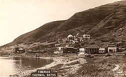
Tiberias is an Israeli city on the western shore of the Sea of Galilee. A major Jewish center during Late Antiquity, it has been considered since the 16th century one of Judaism's Four Holy Cities, along with Jerusalem, Hebron, and Safed. In 2022, it had a population of 48,472.

Kafr ʿInān, is a former Palestinian village, depopulated in the 1948 Arab–Israeli war. It was located around 33 kilometres (21 mi) east of Acre.

Sepphoris, known in Hebrew as Tzipori and in Arabic as Saffuriya is an archaeological site located in the central Galilee region of Israel, 6 kilometres (3.7 mi) north-northwest of Nazareth. It lies 286 meters (938 ft) above sea level and overlooks the Beit Netofa Valley. The site holds a rich and diverse historical and architectural legacy that includes Hellenistic, ancient Jewish, Roman, Byzantine, early Islamic, Crusader, Mamluk and Ottoman remains. In the Roman period, it was also called Diocaesaraea. In Mandatory Palestine, Saffuriya was a Palestinian Arab town with a population of approximately 5000 people at the time of its depopulation in 1948.

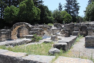
Hamat Gader is a hot springs site in the Yarmuk River valley, located in an area under Israeli control, near the Golan Heights and the border with Jordan.

Naaran was an ancient Jewish village dating to the 5th and 6th century CE, located in the modern-day West Bank. Remains of the village have been excavated north-west of Jericho. Naaran is archeologically notable for a mosaic floor of a synagogue, featuring a large zodiac design, which was discovered at the site.
Beit She'arim, also Besara, was a Jewish village located in the southwestern hills of the Lower Galilee, during the Roman period, from the 1st century BCE to the 3rd century CE. At one point, it served as the seat of the Sanhedrin, the Jewish judicial and religious council.
Kursi is an archaeological site in the Golan Heights containing the ruins of a Byzantine monastery and identified by tradition as the site of Jesus' "Miracle of the Swine". Part of the archaeological site is now an Israeli national park. Kursi takes its name from the Talmudic site. A marble slab with Aramaic text discovered in December 2015 seems to indicate that the settlement had, as of c. 500 CE, a Jewish or Judeo-Christian population.

Kfar Baram synagogue, also Kafar Berem synagogue, is the ruins of two ancient Jewish synagogues at the site of Kafr Bir'im, a depopulated Palestinian village which in medieval times was the Jewish village of Kfar Bar'am. Today, it is located in Northern Israel, 3 kilometers from the Lebanese border.
Susya is a location in the southern Hebron Governorate in the West Bank. It houses an archaeological site with extensive remains from the Second Temple and Byzantine periods, including the ruins of an archeologically notable synagogue, repurposed as a mosque after the Muslim conquest of Palestine in the 7th century. A Palestinian village named Susya was established near the site in the 1830s. The village lands extended over 300 hectares under multiple private Palestinian ownership, and the Palestinians on the site are said to exemplify a southern Hebron cave-dwelling culture present in the area since the early 19th century whose transhumant practices involved seasonal dwellings in the area's caves and ruins of Susya.
Beth Alpha is a sixth-century CE synagogue located at the foot of the northern slopes of the Gilboa mountains near Beit She'an, Israel. It is now part of Bet Alfa Synagogue National Park and managed by the Israel Nature and Parks Authority.

Hurvat Amudim or Sde Amudim was an ancient village, now an archaeological site, in Israel, located south-east of the Beit Netofa Valley, on the eastern side of Highway 65 between Golani Interchange and Kadarim Junction.
The ancient synagogue of Gaza was built in 508 CE during the Byzantine period and was discovered in 1965. It was located in the ancient port city of Gaza, then known as "Maiumas", currently the Rimal district of Gaza City.

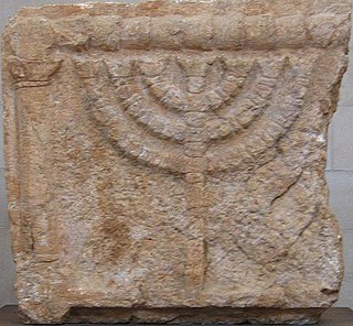
Tzippori Synagogue is an ancient synagogue discovered in Sepphoris, a Roman-era Jewish city in the Galilee, now an archaeological site and a national park in Israel.

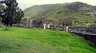
Chorazin or Korazim was an ancient village in the Roman and Byzantine periods, best known from the Christian Gospels. It stood on the Korazim Plateau in the Upper Galilee on a hill above the northern shore of the Sea of Galilee, 2.5 mi (4.0 km) from Capernaum in what is now the territory of modern Israel.

Ancient synagogues in Israel refers to synagogues located in Israel built by communities of Jews and Samaritans from antiquity to the Early Islamic period.
Ancient synagogues in Palestine refers to synagogues and their remains in the Land of Israel/Palestine region, built by the Jewish and Samaritan communities from the time of the Hasmonean dynasty during the Late Hellenistic period, to the Late Byzantine period.

Huqoq or Hukkok was an ancient Jewish village, located 12.5 km north of Tiberias. The area had been settled since ancient times and is mentioned in the Book of Joshua. The Palestinian village of Yaquq later stood at Huqoq's location, and a fort named Hukok was built near the site on 11 July 1945, later followed by a kibbutz.
Bethmaus, or Beth Maʿon, also called Maon, was a Jewish village during the late Second Temple and Mishnaic periods, and which was already a ruin when Kitchener visited the site in 1877. It was situated upon the hill, directly north-west of the old city of Tiberias, at a distance of one biblical mile, rising to an elevation of 250 metres (820 ft) above sea-level. It is now incorporated within the modern city bounds of Upper Tiberias. The remaining structure built over the site is a Sheikh's Tomb.
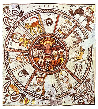
Zodiac mosaics in ancient synagogues are known from at least eight examples from the Land of Israel in the 4th-6th centuries CE during the Byzantine period. As a typical arrangement, the mosaic floors of such synagogues consisted of three panels, the central one containing the Jewish zodiac.