Kafr ʿInān, is a former Palestinian village, depopulated in the 1948 Arab–Israeli war. It was located around 33 kilometres (21 mi) east of Acre.

Gamla, also Gamala, was an ancient Jewish town on the Golan Heights. Believed to have been founded as a Seleucid fort during the Syrian Wars, it transitioned into a predominantly Jewish settlement that came under Hasmonean rule in 81 BCE. The town's name reflects its location on a high, elongated ridge with steep slopes resembling a camel's hump.

Beit She'arim necropolis is an extensive necropolis of rock-cut tombs near the remains of the ancient Jewish town of Beit She'arim. In early modern times the site was the Arab village of Sheikh Bureik; it was depopulated in the 1920s as a result of the Sursock Purchases, and identified as Beit She'arim in 1936 by historical geographer Samuel Klein.
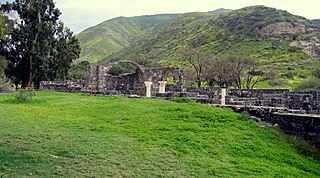
Kursi is an archaeological site in the Golan Heights containing the ruins of a Byzantine monastery and identified by tradition as the site of Jesus' "Miracle of the Swine". Part of the archaeological site is now an Israeli national park. Kursi takes its name from the Talmudic site. A marble slab with Aramaic text discovered in December 2015 seems to indicate that the settlement had, as of c. 500 CE, a Jewish or Judeo-Christian population.

The Peki’in Synagogue, is a synagogue located in the centre of Peki'in, Northern Israel. The current building was erected in 1873, on the site of older ones. Local tradition holds that it has two stones taken from the walls of the Jewish Temple in Jerusalem built into its walls. The site is also said to be where Rabbi Joshua ben Hananiah established his beth midrash in antiquity.

Kfar Baram synagogue, also Kafar Berem synagogue, is the ruins of two ancient Jewish synagogues at the site of Kafr Bir'im, a depopulated Palestinian village which in medieval times was the Jewish village of Kfar Bar'am. Today, it is located in Northern Israel, 3 kilometers from the Lebanese border.

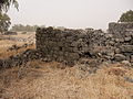
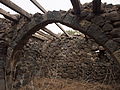
Umm el-Qanatir, also spelled Umm el-Kanatir, also known as Ein Keshatot, is an archaeological site on the Golan Heights, whose main phase is dated to the mid-5th–8th centuries. Excavations have revealed a Roman-period Pagan and later Jewish settlement, who left behind the ruins of an exquisite synagogue when they abandoned the town after it being destroyed by the catastrophic 749 earthquake. The site is located 10 kilometres east of the Dead Sea Transform, one kilometre southwest of Natur.

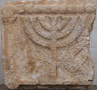
The Golan Archaeological Museum is a museum of the archaeological finds of the Golan Heights, located in Katzrin.
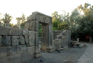
The Katzrin ancient village and synagogue is an open-air museum located in the Golan Heights on the outskirts of the Israeli settlement of Katzrin. It features the partially reconstructed remains of a village from the 4th-8th century CE, that is: mainly from the Byzantine period, but starting from the Late Roman and extending into the Early Muslim era, or in Jewish terms from the Talmudic period.
Eleazar ha-Kappar was a Jewish rabbi of the fifth and last generation of the tannaim. He was a colleague of Judah ha-Nasi and was in the company of him occasionally. He spent most of his life at ancient Katzrin. He was the father of bar Kappara, who is sometimes cited by the same name. He had a nephew named Hiyya, who was known for his pleasant voice.

Ancient synagogues in Israel refers to synagogues located in Israel built by communities of Jews and Samaritans from antiquity to the Early Islamic period.
Ancient synagogues in Palestine refers to synagogues and their remains in the Land of Israel/Palestine region, built by the Jewish and Samaritan communities from the time of the Hasmonean dynasty during the Late Hellenistic period, to the Late Byzantine period.

Katzrin is an Israeli settlement organized as a local council in the Golan Heights. Known as the "capital of the Golan", it is the second-largest locality there after Majdal Shams, and the largest Israeli settlement. In 2022 it had a population of 7,876. It is the seat of Golan Regional Council.
Bethmaus, or Beth Maʿon, also called Maon, was a Jewish village during the late Second Temple and Mishnaic periods, and which was already a ruin when Kitchener visited the site in 1877. It was situated upon the hill, directly north-west of the old city of Tiberias, at a distance of one biblical mile, rising to an elevation of 250 metres (820 ft) above sea-level. It is now incorporated within the modern city bounds of Upper Tiberias. The remaining structure built over the site is a Sheikh's Tomb.

Ein Neshut is an archaeological site where remains of a Jewish settlement from the Talmudic period and an ancient synagogue were discovered in the center of the Golan Heights.

Hurvat Zmimrah, also Zumeimira, is an archaeological site in the center of the Golan Heights, where the remains of a Jewish settlement from the Talmudic period and an ancient synagogue were discovered.
Ramathnia is an abandoned village in the center of the Golan Heights, about 10 kilometers east of Katzrin.

The Deir Aziz synagogue is an ancient synagogue dating from the Mishnaic and Talmudic periods, located at the archeological site of Deir Aziz, in the southern Golan Heights.

Deir Aziz is an ancient Jewish settlement on which a now-abandoned Syrian village was founded in the southern Golan Heights.

Qision was an ancient settlement in Upper Galilee, now an archaeological site in northern Israel, featuring the ruins of the settlement, including a public building, possibly an ancient synagogue, alongside an inscription dedicated to the Roman emperor Septimius Severus and his family commissioned by the local Jewish community.