Copyright-problem.svg
An editor has launched a copyright investigation involving this section. The text under investigation is currently hidden from public view, but is accessible in the page history . Please do not remove this notice or restore blanked content until the issue is resolved by an administrator, copyright clerk, or volunteer response agent.

The purported copyright violation copies text from see talk ( Copyvios report ); as such, this page has been listed on the copyright problems page.

Contents

  • Geography
  • Archeology
  • See also
  • References
  • Further reading

Unless the copyright status of the text of this page or section is clarified and determined to be compatible with Wikipedia's content license, the problematic text and revisions or the entire page may be deleted one week after the time of its listing (i.e. after 19:42, 28 August 2024 (UTC)).

What can I do to resolve the issue?

  • If you hold the copyright to this text, you can license it in a manner that allows its use on Wikipedia.
    1. You must permit the use of your material under the terms of the Creative Commons Attribution-Sharealike 3.0 Unported License (CC BY-SA 3.0) and the GNU Free Documentation License (GFDL) (unversioned, with no invariant sections, front-cover texts, or back-cover texts).
    2. Explain your intent to license the content on this article's discussion page.
    3. To confirm your permission, you can either display a notice to this effect at the site of original publication or send an e-mail from an address associated with the original publication to permissions-enAt sign.svgwikimedia.org or a postal letter to the Wikimedia Foundation. These messages must explicitly permit use under CC BY-SA and the GFDL. See Wikipedia:Donating copyrighted materials.
    4. Note that articles on Wikipedia must be written from a neutral point of view and must be verifiable in published third-party sources; consider whether, copyright issues aside, your text is appropriate for inclusion in Wikipedia.
  • You can demonstrate that this text is in the public domain or is already under a license suitable for Wikipedia. Explain this on this article's discussion page, with reference to evidence. Wikipedia:Public domain and Wikipedia:Compatibly licensed may assist in determining the status.
  • Otherwise, you may rewrite this page without copyright-infringing material. Your rewrite should be placed on this page, where it will be available for an administrator or clerk to review it at the end of the listing period. Follow this link to create the temporary subpage. Please mention the rewrite upon completion on this article's discussion page.
    • Simply modifying copyrighted text is not sufficient to avoid copyright infringement—if the original copyright violation cannot be cleanly removed or the article reverted to a prior version, it is best to write the article from scratch. (See Wikipedia:Close paraphrasing.)
    • For license compliance, any content used from the original article must be properly attributed; if you use content from the original, please leave a note at the top of your rewrite saying as much. You may duplicate non-infringing text that you had contributed yourself.
    • It is always a good idea, if rewriting, to identify the point where the copyrighted content was imported to Wikipedia and to check to make sure that the contributor did not add content imported from other sources. When closing investigations, clerks and administrators may find other copyright problems than the one identified. If this material is in the proposed rewrite and cannot be easily removed, the rewrite may not be usable.

Steps to list an article at Wikipedia:Copyright problems:
  1. Add the following to the bottom of Wikipedia:Copyright problems/2024 August 21: * {{subst:article-cv|Hurvat Zmimrah}} from see talk. ~~~~
  2. Add the following template to the talk page of the contributor of the material: {{subst:Nothanks-web|pg=Hurvat Zmimrah|url=see talk}} ~~~~
  3. Place {{ copyvio/bottom }} at the end of the portion you want to blank. If nominating the entire page, please place this template at the top of the page, set the "fullpage" parameter to "yes", and place {{ copyvio/bottom }} at the very end or the article.
Remains of the ancient synagogue Ancient synagogue.jpg
Remains of the ancient synagogue
Ancient synagogue and ruins on the Golan Heights

Hurvat Zmimrah (originally Khirbat Zmimrah), also Zumeimira, is an archaeological site in the center of the Golan Heights, where the remains of a Jewish [1] settlement from the Talmudic period and an ancient synagogue [2] were discovered.

Geography

The ruins are located about six kilometers south of Katzrin, two kilometers north of the meeting point of Nahal Zavitan with Meshushim River, and above the steep western bank of the Zavitan Stream  [ he ].

Archeology

Relief of a lion near the synagogue Relief of a lion.jpg
Relief of a lion near the synagogue
Remains of an oil press Zmimra oil press.jpg
Remains of an oil press

The archeological discoveries on the site include the remains of an ancient synagogue, with architectural items typical of synagogues in the area, such as: ashlars and column capitals. [1] other findings are building walls and at least two oil presses. [1]

A basalt tablet with an engraving of a seven branched menorah and the four species was also discovered at the site, as well as a relief of a lion, which probably decorated the Torah ark in the building. [2]

Another synagogue from the Talmudic period was also discovered in the ruins of Asallia, about two kilometers north of the site.

See also

  • Ancient synagogues in the Palestine region - refers to the entire Palestine region/Land of Israel
    • Ancient synagogues in Israel - refers to the modern State of Israel

Related Research Articles

<span class="mw-page-title-main">Kafr 'Inan</span> Place in Acre, Mandatory Palestine

Kafr ʿInān, is a former Palestinian village, depopulated in the 1948 Arab–Israeli war. It was located around 33 kilometres (21 mi) east of Acre.

<span class="mw-page-title-main">Gamla</span> Ancient Jewish town in the Golan Heights, destroyed during the Great Jewish Revolt

Gamla, also Gamala, was an ancient Jewish town on the Golan Heights. Believed to have been founded as a Seleucid fort during the Syrian Wars, it transitioned into a predominantly Jewish settlement that came under Hasmonean rule in 81 BCE. The town's name reflects its location on a high, elongated ridge with steep slopes resembling a camel's hump.

as-Samu Ancient biblical and modern settlement in Palestine

As Samu' or es-Samu' is a town in the Hebron Governorate of the West Bank, Palestine, 12 kilometers south of the city of Hebron and 60 kilometers southwest of Jerusalem. The town had a population of 26,011 in 2017.

<span class="mw-page-title-main">Beit She'arim (Roman-era Jewish village)</span> Roman-era ruin in Lower Galilee

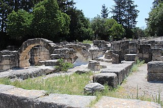
Beit She'arim, also Besara, was a Jewish village located in the southwestern hills of the Lower Galilee, during the Roman period, from the 1st century BCE to the 3rd century CE. At one point, it served as the seat of the Sanhedrin, the Jewish judicial and religious council.

<span class="mw-page-title-main">Kursi, Sea of Galilee</span> Archaeological site on the Golan Heights

Kursi is an archaeological site in the Golan Heights containing the ruins of a Byzantine monastery and identified by tradition as the site of Jesus' "Miracle of the Swine". Part of the archaeological site is now an Israeli national park. Kursi takes its name from the Talmudic site. A marble slab with Aramaic text discovered in December 2015 seems to indicate that the settlement had, as of c. 500 CE, a Jewish or Judeo-Christian population.

<span class="mw-page-title-main">Kfar Bar'am synagogue</span> Ancient synagogue in northern Israel

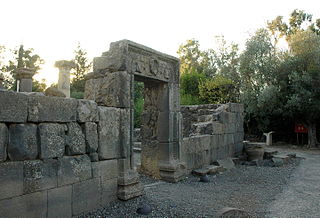
Kfar Baram synagogue, also Kafar Berem synagogue, is the ruins of two ancient Jewish synagogues at the site of Kafr Bir'im, a depopulated Palestinian village which in medieval times was the Jewish village of Kfar Bar'am. Today, it is located in Northern Israel, 3 kilometers from the Lebanese border.

<span class="mw-page-title-main">Jish</span> Local council in Israel

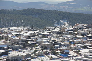
Jish is a local council in Upper Galilee, located on the northeastern slopes of Mount Meron, 13 kilometres (8.1 mi) north of Safed, in Israel's Northern District. In 2022, it had a population of 3,216, which is predominantly Maronite Catholic and Melkite Greek Catholic Christians (63%), with a Sunni Muslim Arab minority.

<span class="mw-page-title-main">Dalton, Israel</span> Place in Northern, Israel

Dalton is a moshav near Safed in northern Israel under the jurisdiction of Merom HaGalil Regional Council. It was founded by immigrants from Tripoli in Libya in 1950 under the leadership of Hapoel HaMizrachi.

<span class="mw-page-title-main">Umm el-Qanatir</span> Archaeological site in the Golan Heights

Umm el-Qanatir, also spelled Umm el-Kanatir, recent Israeli name Ein Keshatot, is an archaeological site on the Golan Heights, whose main phase is dated to the mid-5th–8th centuries. Excavations have revealed a Roman-period Pagan and later Jewish settlement, who left behind the ruins of a synagogue when they abandoned the town after it being destroyed by the catastrophic 749 earthquake. The site is located 10 kilometres east of the Dead Sea Transform, one kilometre southwest of Natur.

<span class="mw-page-title-main">Katzrin ancient village and synagogue</span> Museum and archaeological site in the Golan Heights

The Katzrin ancient village and synagogue (Hebrew: קצרין העתיקה; also Qasrin, Kasrin, from is an open-air museum located in the Golan Heights on the outskirts of the Israeli settlement of Katzrin. It features the partially reconstructed remains of a village from the 4th-8th century CE, that is: mainly from the Byzantine period, but starting from the Late Roman and extending into the Early Muslim era, or in Jewish historiography, the Talmudic period.

<span class="mw-page-title-main">Chorazin</span> Village

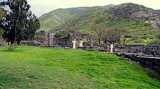
Chorazin or Korazim was an ancient village in the Roman and Byzantine periods, best known from the Christian Gospels. It stood on the Korazim Plateau in the Upper Galilee on a hill above the northern shore of the Sea of Galilee, 2.5 mi (4.0 km) from Capernaum in what is now the territory of modern Israel.

<span class="mw-page-title-main">Ancient synagogues in Palestine</span>

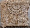
Ancient synagogues in Palestine refers to synagogues and their remains in the Land of Israel/Palestine region, built by the Jewish and Samaritan communities from the time of the Hasmonean dynasty during the Late Hellenistic period, to the Late Byzantine period.

<span class="mw-page-title-main">Sea to Sea Hiking Trail</span> Long distance Hiking path crossing the north of Israel

The Sea to Sea Hiking Trail is a long distance hiking trail that crosses the north of Israel, its western end on the coast of the Mediterranean Sea at Achziv National Park near the Lebanese border in the far north of the country, extending eastward to the coast of the Sea of Gallilee near Kibbutz Ginosar, with a total length of about 70 km (43 mi). When hiked from west to east the total elevation gain and loss are about 1.56 km and 1.77 km respectively. The trail is marked with different colors in different sections but is accompanied by purple circles throughout the trail. It takes an average of 3–5 days to complete.

<span class="mw-page-title-main">Katzrin</span> Israeli settlement in the Golan Heights

Katzrin is an Israeli settlement organized as a local council in the Golan Heights. Known as the "capital of the Golan", it is the second-largest locality there after Majdal Shams, and the largest Israeli settlement. In 2022 it had a population of 7,876. It is the seat of Golan Regional Council.

<span class="mw-page-title-main">Horvat Maon (Hebron Hills)</span> Ancient biblical settlement near Hebron

Horvat Maon/Horvat Ma'on, Arabic: Khirbet Ma'in or Tell Máîn, is an archaeological site in the Hebron Hills, West Bank, rising 863 metres (2,831 ft) above sea level, where the remains of the ancient town of Ma'on have been excavated. The town, now a ruin, is mentioned in the Book of Joshua and the Books of Samuel. It still had a Jewish population during the Roman and Byzantine periods, and a synagogue was discovered there.

<span class="mw-page-title-main">Ein Nashut</span> Archaeological site

Ein Neshut is an archaeological site where remains of a Jewish settlement from the Talmudic period and an ancient synagogue were discovered in the center of the Golan Heights.

<span class="mw-page-title-main">Deir Aziz synagogue</span> Ancient synagogue in the southern Golan Heights

The Deir Aziz synagogue is an ancient synagogue dating from the Mishnaic and Talmudic periods, located at the archeological site of Deir Aziz, in the southern Golan Heights.

<span class="mw-page-title-main">Deir Aziz</span> Archaeological site in the Golan Heights

Deir Aziz is an ancient Jewish settlement on which a now-abandoned Syrian village was founded in the southern Golan Heights.

<span class="mw-page-title-main">Qision</span> Ancient Jewish settlement in Upper Galilee

Qision was an ancient settlement in Upper Galilee, now an archaeological site in northern Israel, featuring the ruins of the settlement, including a public building, possibly an ancient synagogue, alongside an inscription dedicated to the Roman emperor Septimius Severus and his family commissioned by the local Jewish community.

<span class="mw-page-title-main">Kfar Devora</span> Archaeological site in Golan Heights

Kfar Dvora was a Jewish settlement during the Talmudic period in the upper Gilbon River in the Golan Heights. At the site, remains of a Jewish settlement, synagogue, a Beth midrash, 5 inscriptions in Aramaic, 1 in Greek, and one in Hebrew were discovered, which was a novelty in research, as it indicated the existence of a Beth midrash in the place. Many decorated stones were also found, integrated into secondary construction and scattered in the area. On the ruins of Kfar Dvora, the Syrian village of Daburiya was established, which is currently abandoned. Before the Six-Day War, the village was inhabited by Bedouins of the Na'arna tribe, who made secondary use of the stones from the ancient Jewish settlement for construction purposes. The village is currently located northwest of the settlement of kidmat Tzvi.

References

  1. 1 2 3 "בתי כנסת עתיקים בגולן- אומנות ואדריכלות". The Bornblum Eretz Israel Synagogues Website (in Hebrew). Retrieved 2024-03-31.
  2. 1 2 "בתי כנסת קדומים ברמת הגולן / דפנה וערן מאיר ; [עורכת רות פלג ; העורך המדעי - צבי אורי מעוז] | מאיר, דפנה (מאיר, ערן | מאיר, ערן ;פלג, רות ;מעוז, צבי אורי ;יד יצחק בן צבי (ירושלים) | הספרייה הלאומית". www.nli.org.il (in Hebrew). Retrieved 2024-03-31.

Further reading

  • A. Schiller, Ariel: Journal for the Knowledge of the Land of Israel, Issue 50 - The Golan, 5777-1987, p. 156.
  • v
  • t
  • e
Ancient synagogues (Second Temple and Talmudic periods)
Land of Israel
Judea
  • Anim
  • Dikke
  • Ein Gedi
  • Eshtemoa
  • Gaza
  • Jericho
  • Ma'on (Daroma)
  • Naaran
  • Theodotos
  • Umm el-Umdan
  • Wadi Qelt
Galilee
  • Arbel
  • Bar'am
  • Capernaum
  • Chorazin
  • Hammat Tiberias
  • Hurvat Amudim
  • Kfar Hananiah
  • Maoz Haim
  • Migdal
  • Nabratein
  • Peki'in
  • Shema
  • Shfaram
  • Susya
  • Tzippori
  • Qision
Gaulanitis
  • Deir Aziz
  • Ein Nashut
  • Gamla
  • Katzrin
  • Kfar Devora
  • Ein Keshatot
  • Zmimrah
Negev
  • Horvat Rimmon
  • Ma'on (Negev)
Eshtemoa menorah.jpg
Asia Minor and Syria
  • Adrianke
  • Dura-Europos
  • Priene
  • Sardis
Greece and the Balkans
  • Agora of Athens
  • Delos
  • Philippopolis
  • Stobi
Italy, Iberia and North Africa
  • Bova Marina
  • Elche
  • Hammam-Lif
  • Ostia
This page is based on this Wikipedia article
Text is available under the CC BY-SA 4.0 license; additional terms may apply.
Images, videos and audio are available under their respective licenses.