This article includes a list of general references, but it lacks sufficient corresponding inline citations .(March 2024) |
| Ein Neshut synagogue | |
|---|---|
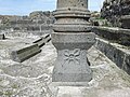
 The ancient synagogue remains, in 2016 | |
| Religion | |
| Affiliation | Judaism (former) |
| Ecclesiastical or organisational status | |
| Status | Ruins |
| Location | |
| Location | near Katzrin, Golan Heights |
| Country | Israel |
 Location of the ancient synagogue in the Golan Heights | |
| Geographic coordinates | 33°0′47.2″N35°41′31.9″E / 33.013111°N 35.692194°E |
| Architecture | |
| Completed | c. 5th century CE |
| Interior area | 10 by 11 m (33 by 36 ft) |
Ein Neshut is an archaeological site where remains of a Jewish settlement from the Talmudic period and an ancient synagogue were discovered in the center of the Golan Heights. [1]