Related Research Articles

Bayt Nabala or Beit Nabala was a Palestinian Arab village in the Ramle Subdistrict in Palestine that was destroyed during the 1948 Arab–Israeli War. The village was in the territory allotted to the Arab state under the 1947 UN Partition Plan, which was rejected by Arab leaders and never implemented. Its population in 1945, before the war, was 2,310.

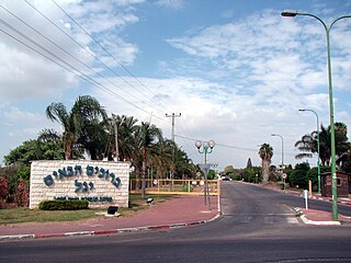
Kfar Chabad is a Chabad-Lubavitch community settlement (town) in the Central District of Israel. Between Beit Dagan and Lod, it falls under the jurisdiction of Sdot Dan Regional Council. In 2022 it had a population of 6,720.

Kafr 'Ana was a Palestinian town located 11 kilometers (6.8 mi) east of Jaffa, built on the ancient site of Ono. In 1945, the town had an estimated population of 2,800 Arabs and 220 Jews. The village was captured by the Haganah in April during the 1948 Palestine war. A number of Palestinian villagers were killed and the rest fled or were expelled, whereafter the village was destroyed. Today, the old village site lies within the modern Israeli city of Or Yehuda.

Azor is a local council in the Tel Aviv District of Israel, on the old Jaffa-Jerusalem road southeast of Tel Aviv. Established in 1948, Azor was granted local council status in 1951. In 2022 it had a population of 13,593, and has a jurisdiction of 2,415 dunams.

Yazur was a Palestinian Arab town located 6 kilometers (3.7 mi) east of Jaffa. Mentioned in 7th century BCE Assyrian texts, the village was a site of contestation between Muslims and Crusaders in the 12th-13th centuries.

Rantiya was a Palestinian village, located 16 kilometers east of Jaffa. During the British Mandate in Palestine, in 1945 it had a population of 590 inhabitants.

Beit Arif is a moshav in the Central District of Israel. Located adjacent to the town of Shoham, it falls under the jurisdiction of Hevel Modi'in Regional Council. In 2022 it had a population of 1,203.
Yagel is a religious moshav in the Central District of Israel. Located near Lod and Ben Gurion International Airport, it falls under the jurisdiction of Sdot Dan Regional Council. In 2022 it had a population of 905.

Kharbatha Bani Harith is a Palestinian village in the central West Bank, located 15 kilometers west of Ramallah in the Ramallah and al-Bireh Governorate. According to the Palestinian Central Bureau of Statistics, the village had a population of 3,471 in 2017. It has a total land area of 7,120 dunams.

Al-Safiriyya was a Palestinian Arab village in the Jaffa Subdistrict. It was depopulated during Operation Hametz in the 1948 Palestine War on May 20, 1948. It was located 11 km east of Jaffa, 1.5 km west of Ben Gurion Airport.

Al-Sawalima was a Palestinian Arab village in the Jaffa Subdistrict. It was depopulated during the 1947–1948 Civil War in Mandatory Palestine on March 30, 1948. It was located 11 km northeast of Jaffa, situated 2 km north of the al-'Awja River.
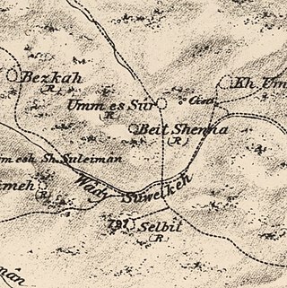
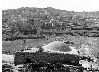
Bayt Shanna was a Palestinian Arab village in the Ramle Subdistrict of Mandatory Palestine. It was depopulated during the 1948 Arab–Israeli War on July 15, 1948, during the second stage of Operation Dani. It was located 11.5 km southeast of Ramla.

Bir Ma'in was a Palestinian Arab village in the Ramle Subdistrict. It was depopulated during the 1948 Arab-Israeli War on July 15, 1948 during the second phase of Operation Danny by the First and Second Battalions of the Yiftach Brigade. It was located 14 km east of Ramla. The village was defended by the Jordanian Army.
'Innaba, also spelled 'Annaba, was a Palestinian village in the Ramle Subdistrict of Mandatory Palestine. It was depopulated during the 1948 Arab–Israeli War on July 10, 1948 by the Yiftach and Eighth Brigades of Operation Dani. It was located 7 km east of Ramla.
Kharruba was a Palestinian Arab village in the Ramle Subdistrict of Mandatory Palestine, near Modi'in. It was located 8 km east of Ramla. It was depopulated on July 12, 1948, during the 1948 Arab–Israeli War.

Al-Kunayyisa was a small Palestinian Arab village in the Ramle Subdistrict. It was depopulated during the 1948 Arab–Israeli War on July 10, 1948, under the first stage of Operation Dani. It was located 12 km southeast of Ramla.

Jisr Jindas, Arabic for "Jindas Bridge", also known as Baybars Bridge, was built in 1273 CE. It crosses a small wadi, known in Hebrew as the Ayalon River, on the old road leading south to Lod and Ramla. The bridge is named after the historic village of Jindas, which stood east of the bridge. It is the most famous of the several bridges erected by Sultan Baybars in Palestine, which include the Yibna and the Isdud bridges.
Kafr Jinnis is an ancient site in modern-day Israel, 2 kilometers west of Ben Gurion Airport in Israel's Central District.
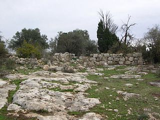
Jindas is an archaeological site in modern-day Israel, 2 kilometers east of the city of Lod in Israel's Central District.
Beit Qufa is an archaeological site in the Lod Valley, near the modern Israeli settlement of Beit Nehemia in Israel's Central District.
References
- ↑ Marom, Roy; Zadok, Ran (2023). "Early-Ottoman Palestinian Toponymy: A Linguistic Analysis of the (Micro-)Toponyms in Haseki Sultan's Endowment Deed (1552)". Zeitschrift des Deutschen Palästina-Vereins. 139 (2).
- 1 2 Lazar, Dorit (1999). "A Mamluk and Ottoman Settlement at Giv'at Dani in the Ayalon Valley". 'Atiqot / עתיקות. 38: 231–232. ISSN 0792-8424. JSTOR 23459438.
- 1 2 לזר, דורית (1999). "גבעת דני: יישוב מן התקופות הממלוכית והעות'מאנית בעמק איילון". 'Atiqot / עתיקות. 38: 127*–136*. ISSN 0792-8424. JSTOR 23459414.
- ↑ Marom, Roy (2022-11-01). "Jindās: A History of Lydda's Rural Hinterland in the 15th to the 20th Centuries CE". Lod, Lydda, Diospolis. 1: 8.
- ↑ Hütteroth and Abdulfattah, 1977, p. 155
- ↑ Marom, Roy (2022). "Lydda Sub-District: Lydda and its Countryside During the Ottoman Period". Diospolis: 117.
- ↑ Marom, Roy (2022-11-01). "Jindās: A History of Lydda's Rural Hinterland in the 15th to the 20th Centuries CE". Lod, Lydda, Diospolis: 13–14.
- ↑ Marom, Roy (2022). "Lydda Sub-District: Lydda and its countryside during the Ottoman period". Diospolis - City of God: Journal of the History, Archaeology and Heritage of Lod. 8: 103–136.