Safed is a city in the Northern District of Israel. Located at an elevation of up to 937 m (3,074 ft), Safed is the highest city in the Galilee and in Israel.

A sanjak was an administrative division of the Ottoman Empire. The Ottomans also sometimes called the sanjak a liva from the name's calque in Arabic and Persian.

The administrative divisions of the Ottoman Empire were administrative divisions of the state organisation of the Ottoman Empire. Outside this system were various types of vassal and tributary states.

The Eyalet of Sidon was an eyalet of the Ottoman Empire. In the 19th century, the eyalet extended from the border with Egypt to the Bay of Kisrawan, including parts of modern Israel and Lebanon.
Ottoman Syria is a historiographical term used to describe the group of divisions of the Ottoman Empire within the region of Levant, usually defined as being east of the Mediterranean Sea, west of the Euphrates River, north of the Arabian Desert and south of the Taurus Mountains.
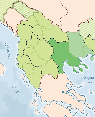
North Macedonia was part of the Ottoman Empire for over 500 years, from the late 14th century until the Treaty of Bucharest in 1913. Before its conquest, this area was divided between various Serbian feudal principalities. Later, it became part of the Ottoman province or Eyalet of Rumelia. The name Rumelia means "Land of the Romans" in Turkish, referring to the lands conquered by the Ottoman Turks from the Byzantine Empire.
The Vilayet of Beirut was a first-level administrative division (vilayet) of the Ottoman Empire. It was established from the coastal areas of the Syria Vilayet in 1888 as a recognition of the new-found importance of its then-booming capital, Beirut, which had experienced remarkable growth in the previous years — by 1907, Beirut handled 11 percent of the Ottoman Empire's international trade. It stretched from just north of Jaffa to the port city of Latakia. It was bounded by the Syria Vilayet to the east, the Aleppo Vilayet to the north, the autonomous Mutasarrifate of Jerusalem to the south and the Mediterranean Sea to the west.
The Sanjak of Zor was a sanjak of the Ottoman Empire, which was created in 1857. Some of its area was separated from the Baghdad Vilayet. Zor was sometimes mentioned as being part of the Aleppo Vilayet, or of the Syria Vilayet.
A vilayet, also known by various other names, was a first-order administrative division of the later Ottoman Empire. It was introduced in the Vilayet Law of 21 January 1867, part of the Tanzimat reform movement initiated by the Ottoman Reform Edict of 1856. The Danube Vilayet had been specially formed in 1864 as an experiment under the leading reformer Midhat Pasha. The Vilayet Law expanded its use, but it was not until 1884 that it was applied to all of the empire's provinces. Writing for the Encyclopaedia Britannica in 1911, Vincent Henry Penalver Caillard claimed that the reform had intended to provide the provinces with greater amounts of local self-government but in fact had the effect of centralizing more power with the sultan and local Muslims at the expense of other communities.

The Eyalet of Rumeli, or Eyalet ofRumelia, known as the Beylerbeylik of Rumeli until 1591, was a first-level province of the Ottoman Empire encompassing most of the Balkans ("Rumelia"). For most of its history, it was the largest and most important province of the Empire, containing key cities such as Edirne, Yanina (Ioannina), Sofia, Filibe (Plovdiv), Manastır/Monastir (Bitola), Üsküp (Skopje), and the major seaport of Selânik/Salonica (Thessaloniki). It was also among the oldest Ottoman eyalets, lasting more than 500 years with several territorial restructurings over the long course of its existence.
Damascus Eyalet was an eyalet of the Ottoman Empire. Its reported area in the 19th century was 51,900 square kilometres (20,020 sq mi). It became an eyalet after the Ottomans took it from the Mamluks following the 1516–1517 Ottoman–Mamluk War. Janbirdi al-Ghazali, a Mamluk traitor, was made the first beylerbey of Damascus. The Damascus Eyalet was one of the first Ottoman provinces to become a vilayet after an administrative reform in 1865, and by 1867 it had been reformed into the Syria Vilayet.
The Mutasarrifate of Jerusalem, also known as the Sanjak of Jerusalem, was an Ottoman district with special administrative status established in 1872. The district encompassed Jerusalem as well as Hebron, Jaffa, Gaza and Beersheba. During the late Ottoman period, the Mutasarrifate of Jerusalem was commonly referred to as Palestine; a very late Ottoman document describes Palestine as including the Sanjak of Nablus and Sanjak of Akka (Acre) as well, more in line with European usage. It was the 7th most heavily populated region of the Ottoman Empire's 36 provinces.

The Sanjak of Preveza, also once known as the Liva of Preveza, was a sanjak of the Ottoman Empire named for its capital at Preveza in southern Epirus, now part of northwestern Greece. The sanjak existed from its formation in 1863 until its conquest in the First Balkan War and reorganization in 1915 as the Preveza Prefecture of the Kingdom of Greece.
The Sanjak of Gelibolu or Gallipoli was a second-level Ottoman province encompassing the Gallipoli Peninsula and a portion of southern Thrace. Gelibolu was the first Ottoman province in Europe, and for over a century the main base of the Ottoman Navy. Thereafter, and until the 18th century, it served as the seat of the Kapudan Pasha and capital of the Eyalet of the Archipelago.
The Sanjak of Salonica, Selanik, or Thessalonica was a sanjak of the Ottoman Empire. It was named for its capital Salonica, also known by its Turkish name Selanik and its latinized Greek name Thessalonica. It was also known under the Ottomans as the Liva of Salonica &c.. The sanjak existed from its formation in 1430 as part of the Rumeli Eyalet until its conquest in the First Balkan War in 1912 and its reorganization in 1915 as the Thessalonica Prefecture of the Kingdom of Greece. It served as the pasha sanjak of the Eyalet of Salonica from 1846–1867 and of the Vilayet of Salonica from 1867–1912.

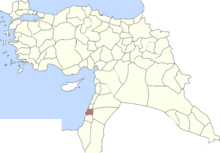
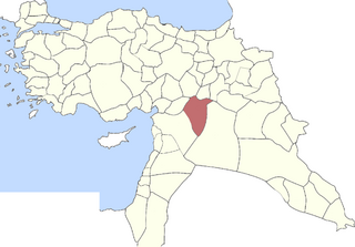
Safed Sanjak was a sanjak (district) of Damascus Eyalet in 1517–1660, after which it became part of the Sidon Eyalet. The sanjak was centered in Safed and spanned the Galilee, Jabal Amil and the coastal cities of Acre and Tyre. The city of Safed was made up of Muslim and Jewish townspeople. At the same time the rest of the sanjak was populated by Sunni Muslims, Jewish peasants, Bedouin tribesmen, Shia Muslims/Mitwali, and Druze peasants.

The Mutasarrifate of Karak, also known as the Sanjak of Karak, was an Ottoman district with special administrative status established in 1895, located in modern-day Jordan. The city of Karak was the district's capital. It had a population of 72,562 in 1914.
Sidon-Beirut Sanjak was a sanjak (district) of Sidon Eyalet of the Ottoman Empire. Prior to 1660, the Sidon-Beirut Sanjak had been part of Damascus Eyalet, and for brief periods in the 1590s, Tripoli Eyalet.
The Urfa Sanjak, previously known as Sanjak of Birejik, was a prefecture (sanjak) of the Ottoman Empire, located in modern-day Turkey and Syria. The city of Urfa was the Sanjak's capital.
The 1585 Ottoman expedition against the Druze, also called the 1585 Ottoman invasion of the Chouf, was an Ottoman military campaign led by Ibrahim Pasha against the Druze and other chieftains of Mount Lebanon and its environs, then a part of the Sidon-Beirut Sanjak of the province of Damascus Eyalet. It had been traditionally considered the direct consequence of a raid by bandits in Akkar against the tribute caravan of Ibrahim Pasha, then Egypt's outgoing governor, who was on his way to Constantinople. Modern research indicates that the tribute caravan arrived intact and that the expedition was instead the culmination of Ottoman attempts to subjugate the Druze and other tribal groups in Mount Lebanon dating from 1518.