Sheikh Danun

Last updated • 5 min readFrom Wikipedia, The Free Encyclopedia

Sheikh Dannun
שֵּׁיח' דַּנּוּן
الشيخ دنون
Hebrew  transcription(s)
  officialSheikh Dannun
Sheikh danun.jpg
School in Sheikh Danun
Etymology: The shrine of Sheik Dannun, The shrine of Sheik David [1]
Israel outline northwest.png
Red pog.svg
Sheikh Dannun
Israel location map with stripes.svg
Red pog.svg
Sheikh Dannun
Coordinates: 32°59′30″N35°8′52″E / 32.99167°N 35.14778°E / 32.99167; 35.14778
Grid position164/266 PAL
CountryFlag of Israel.svg  Israel
District Northern
Council Mateh Asher
Population
 (2022) [2]
3,031

Sheikh Dannun (Arabic : الشيخ دنون, Hebrew : שֵּׁיח' דַּנּוּן); also transliterated as Sheikh Danun and Sheikh Danon) is an Arab village located in Israel's Northern District. Since 1948, it has been made up of two old villages – Shaykh Danun and Shaykh Dawud (or Daud, meaning "David") – which were merged, and are now jointly referred to as Sheikh Dannun. Located on a hill overlooking the plains of Acre, both of these old villages were built around a tomb for a sheikh, and share a similar history. [3] It falls under the jurisdiction of Mateh Asher Regional Council, and in 2022 it had a population of 3,031. [2]

Contents

History

The history of the site is ancient. Burial chambers dated to the Intermediate Bronze Age were discovered in the north of the modern day village, at the end of a shaft leading from a man-made cave carved into the northern slope of the chalk hill upon which Sheikh Dawud is situated. Potsherds dating to the Byzantine and Ottoman periods have also been collected at the site. [4] An old quarry has been excavated, including a small area probably used as a winepress. [5]

Khirbet Buda, another ancient site identified at the southeast corner of the modern village, contains remains from the Roman or Byzantine period. These include three oil presses, tombs with loculi of which one is engraved with a cross, and one grave with a square courtyard containing three arcosolia . [6] Under the name Kfar Barada (possibly a calligraphic error) it was mentioned as part of the domain of the Crusaders during the hudna between the Crusaders based in Acre and the Mamluk sultan al-Mansur (Qalawun) in 1283. [7]

Ottoman era

Jacotin's map of the area, in 1799 AcreNE1799.jpg
Jacotin's map of the area, in 1799
Survey of Western Palestine map from 1880, showing the area, including Kh. Buda AcreNorth1870s.jpg
Survey of Western Palestine map from 1880, showing the area, including Kh. Buda

A map by Pierre Jacotin from Napoleon's invasion of 1799 shows both places, named as Cheik Daoud and Cheik Denou. [9]

Both villages are mentioned in the writings of Western travellers to Ottoman Palestine in the 19th century. Andrew Alexander Bonar and Robert Murray M'Cheyne who visited in the mid-19th century describe Sheikh Daud as one of many small villages scattered over a "beautiful plain", located just off the road, that was "once a Christian village." [10] V. Guérin, who visited the place later that same century, described Danun as a hamlet grouped around the tomb of Shaykh Danun. Of the shrine (wali) in neighbouring Shaykh Dawud, he writes that it was surmounted by two domes, one larger than the other and estimated the population of that hamlet to be about 50. One house in the village is described as larger and better built than the others and said to belong to a powerful sheikh. [11]

In 1881, the PEF's Survey of Western Palestine (SWP) writes of Shaykh Danun that it was a "small village, built of stone and mud, contains about 50 Muslims, on the edge of a plain, with stream of water near." [12] Shaykh Dawud is similarly described, but with 70 Muslims, and "surrounded by olives and arable land." [12]

A population list from about 1887 showed that Sheikh Daud had about 320 inhabitants, all Muslim. [13]

British Mandate era

At the time of the 1922 census of Palestine conducted by the British Mandate, Shaikh Danun had a population of 106, while Sheikh Daud had 193 people, all Muslims. [14] The 1931 census listed 39 inhabited houses in Sheikh Danun, populated by 155 Muslim inhabitants. Sheikh Dawud had 48 houses, inhabited by 222 Muslims. [15]

In the 1945 statistics, the population was counted with the nearby villages of Al-Ghabisiyya and Shaykh Dawud. Together, they had 690 inhabitants, still all Muslim, [16] and 11,771 dunums of land. [17] Of this, a total of 6,633 dunums of land in the three villages were used for cereals, 1,371 dunums were irrigated or used for orchards, [18] while 58 dunams were built-up (urban) land. [19]

State of Israel

According to Dawud Bader, Sheikh Danun has later received many new inhabitants, including internally displaced persons from the depopulated Arab villages of al-Ghabisiyya, Amqa, Kuwaykat, al-Nahr and Umm al-Faraj. [20]

Shrines

A report by the Palestine Antiquities Department (1931) on Shaykh Danun found that the village contained a built Maqam (shrine), with a few houses and rock-cuttings located nearby. [3] Andrew Petersen, an archaeologist specializing in Islamic architecture, visited the Maqam Shaykh Danun in 1991, and notes that though it is hidden amongst houses, it is visible because of its tall white dome. He describes the shrine as consisting of two parts: one modern concrete annex on the north side, and one older part containing a prayer room and a mausoleum. [3] The prayer room was built after the mausoleum, probably during the period of Ottoman rule in Palestine. [21] A large square room roofed by a large dome, it has a mihrab in the south wall, next to a modern stone minbar. [3] The mausoleum has an iwan at its north end, and the stone cenotaph beneath it is covered in green cloth. Below a wooden frame in the middle of the room is the entrance to a cave. Based on the design, Petersen determined that the mausoleum may date to the Mamluk era, while the cave is probably a Byzantine era tomb that was subsequently reused. [21]

The Maqam Shaykh Dawud stands in the middle of a cemetery on the summit of a hill. It is covered by two large domes and one smaller one. The interior is divided into two parts, consisting of a prayer room and a mausoleum. The mausoleum contains two cenotaphs. According to the villagers, Dawud (Arabic for "David") was a Muslim warrior who died fighting the Crusaders. Petersen dates the mausoleum to the medieval period (i.e. pre-16th century), while the prayer room might be newer, possibly from Ottoman times. [21]

Demographics

Sheikh Danun is one of the two Arab localities in Mateh Asher Regional Council. According to the Israel Central Bureau of Statistics (2006), the village had a population of 2,300 mostly Muslim inhabitants. [22]

See also

Related Research Articles

<span class="mw-page-title-main">Amka</span> Place in Northern, Israel

Amka, also known in Arabic as Amqa, is a moshav in the Matte Asher Regional Council of Israel's Northern District, near Acre. The location of the moshav roughly corresponds the former Palestinian village, depopulated during the 1948 Arab–Israeli War. Yemenite Jews founded the village's successor Amka in 1949. In 2022, its population was 833.

<span class="mw-page-title-main">Nahf</span> Arab town in northern Israel

Nahf is an Arab town in the Northern District of Israel. It is located in between the lower and upper Galilee, about 23 kilometres (14 mi) east of Acre. In 2022 it had a population of 13,717. Archaeologists believe that the area was an important center for viticulture in the Hellenistic period and possibly the Early Bronze Age IB period.

<span class="mw-page-title-main">Al-Ghabisiyya</span> Place in Acre, Mandatory Palestine

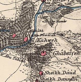
Al-Ghabisiyya was a Palestinian Arab village in northern Palestine, 16 km north-east of Acre in present-day Israel. It was depopulated by the Israel Defense Forces during the 1948 Palestinian expulsion and remains deserted.

<span class="mw-page-title-main">Al-Shaykh Muwannis</span> Place in Jaffa, Mandatory Palestine

Al-Shaykh Muwannis, also Sheikh Munis, was a small Palestinian Arab village in the Jaffa Subdistrict of Mandatory Palestine, located approximately 8.5 kilometers from the center of Jaffa city in territory earmarked for Jewish statehood under the UN Partition Plan. The village was abandoned in March 1948 due to the threats of Jewish militias, two months before the 1948 Arab–Israeli war. Today, Tel Aviv University lies on part of the village land.

<span class="mw-page-title-main">Al-Sarafand</span> Place in Haifa, Mandatory Palestine

Al-Sarafand was a Palestinian Arab village near the Mediterranean shore south of Haifa. In Ottoman tax records, it is shown that the village had a population of 61 inhabitants in 1596. According to a land and population survey by Sami Hadawi, al-Sarafand's population was 290 in 1945, entirely Arab.

<span class="mw-page-title-main">Julis</span> Local council in Israel

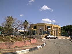
Julis is a Druze village and local council in the Northern District of Israel. In 2022 it had a population of 6,738.

<span class="mw-page-title-main">Iraq al-Manshiyya</span> Place in Gaza, Mandatory Palestine

Iraq al-Manshiyya was a Palestinian Arab village located 32 km northeast of Gaza City. The village contained two mosques and a shrine for Shaykh Ahmad al-Arayni. It was depopulated after the 1948 Arab-Israeli War.

<span class="mw-page-title-main">Al-Yamun</span> Town in Jenin Governorate, West Bank, Palestine

Al-Yamun is a Palestinian town located nine kilometers west of Jenin in the Jenin Governorate of Palestine, in the northern West Bank. Al-Yamun's land area consists of approximately 20,000 dunams, of which 1,300 dunams is built-up area.

<span class="mw-page-title-main">Uzeir</span> Place in Northern, Israel

Uzeir is an Arab village in northern Israel. Located near Nazareth Illit in the Lower Galilee, it falls under the jurisdiction of al-Batuf Regional Council. In 2022 it had a population of 3,511.

<span class="mw-page-title-main">Zeita, Tulkarm</span> Municipality type D in Tulkarm, State of Palestine

Zeita is a Palestinian town in the Tulkarm Governorate in the western West Bank, located 11 kilometers North-east of Tulkarm. According to the Palestinian Central Bureau of Statistics, Zeita had a population of 3,078 inhabitants in 2017. 21.5% of the population of Zeita were refugees in 1997. The healthcare facilities for Zeita are designated as MOH level 2.

<span class="mw-page-title-main">Farradiyya</span> Place in Safad, Mandatory Palestine

Farradiyya was a Palestinian Arab village of 670 located 8 kilometers (5.0 mi) southwest of Safad, A Jewish settlement called 'Farod' was built atop the once ruined village.

<span class="mw-page-title-main">Bayt Jiz</span> Place in Ramle, Mandatory Palestine

Bayt Jiz was a Palestinian Arab village situated on undulating land in the western foothills of the Jerusalem heights, 15 kilometers (9.3 mi) southwest of Ramla. In 1945, it had a population of 550. It was occupied by Israeli forces in the 1948 Arab–Israeli War and became depopulated.

<span class="mw-page-title-main">Sirin, Baysan</span> Place in Baysan, Mandatory Palestine

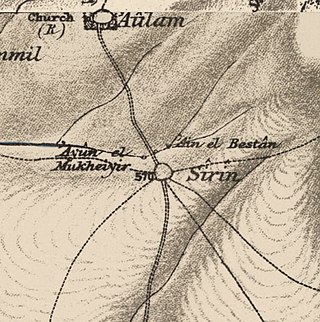
Sirin, was a Palestinian Arab village located 17 kilometers (11 mi) north of Beisan. The village was depopulated and destroyed in 1948. Only the village cemetery and one house remain standing, along with the remains of a mosaic pavement and a vaulted spring dating to the Byzantine period. Mentioned in historical documents, the 1596 census indicated it had 45 households; by 1945, the number of inhabitants had risen to 810.

<span class="mw-page-title-main">Yajur, Haifa</span> Place in Haifa, Mandatory Palestine

Yajur was a Palestinian Arab village located 9.5 kilometres (5.9 mi) southeast of Haifa. It was depopulated during the 1947–48 Civil War in Mandatory Palestine on April 25, 1948.

<span class="mw-page-title-main">Dayr Nakhkhas</span> Place in Hebron, Mandatory Palestine

Dayr Nakhkhas was a Palestinian Arab village located 20 km northwest of Hebron, overlooking Wadi Bayt Jibrin to the north.

<span class="mw-page-title-main">Dayr al-Shaykh</span> Former Palestinian Arab village in the Jerusalem corridor

Dayr al-Shaykh, also spelt Deir esh Sheikh, was a Palestinian Arab village in the Jerusalem Subdistrict, also known as the Jerusalem corridor. It was located 16 kilometers (9.9 mi) west of Jerusalem.

<span class="mw-page-title-main">Al-Qubayba, Ramle</span> Arab village in Mandatory Palestine

Al-Qubayba was a Palestinian Arab village in the Ramle Subdistrict. It was depopulated during the 1948 Arab-Israeli War on May 27, 1948, by the Givati Brigade as part of the Second stage of Operation Barak. It was located 10.5 km southeast of Ramla near the Rubin River which provided the village with water and irrigation for agriculture. Al-Qubayba was mostly destroyed with the exception of a few houses, and Kfar Gevirol was built in its place, now a suburb in the west of Rehovot.

<span class="mw-page-title-main">Biriyya</span> Place in Safad, Mandatory Palestine

Biriyya was a Palestinian Arab village in the Safad Subdistrict. It was depopulated during the 1947–1948 Civil War in Mandatory Palestine on May 2, 1948, by The Palmach's First Battalion of Operation Yiftach. It was located 1.5 kilometres (0.9 mi) northeast of Safad. Today the Israeli moshav of Birya includes the village site.

<span class="mw-page-title-main">Qabba'a</span> Village in Safad, Mandatory Palestine

Qabba'a was a Palestinian Arab village in the District of Safad. It was depopulated during the 1948 War on May 26, 1948, by the Palmach's First Battalion of Operation Yiftach. It was located 6 km northeast of Safad.

<span class="mw-page-title-main">Fardisya</span> Place in Tulkarm, Mandatory Palestine

Fardisya was a Palestinian Arab hamlet in the Tulkarm Subdistrict, 2.5 kilometres (1.6 mi) south of Tulkarm.

References

  1. Palmer, 1881, pp. 10 54
  2. 1 2 "Regional Statistics". Israel Central Bureau of Statistics. Retrieved 21 March 2024.
  3. 1 2 3 4 Petersen, 2002, p. 281
  4. Getzov, 2008, Sheikh Danon, Esh-Sheikh Dawud Final Report
  5. Porat, 2006, Sheikh Danon Final Report
  6. Dauphin, 1998, p. 636
  7. Barag, 1979, pp. 203–204.
  8. Jacotin, 1826. See also Siege of Acre (1799)
  9. Karmon, 1960, p. 162.
  10. Bonar and M'Cheyne, 1849, p. 315.
  11. Guérin, 1880, pp. 29-30. Cited in Petersen, 2002, pp. 281-2
  12. 1 2 Conder and Kitchener, 1881, SWP I, p. 147
  13. Schumacher, 1888, p. 172
  14. Barron, 1923, Table XI, Sub-district of Acre, p. 36
  15. Mills, 1932, pp. 102–103
  16. Government of Palestine, Department of Statistics, 1945, p. 4
  17. Government of Palestine, Department of Statistics. Village Statistics, April 1945. Quoted in Hadawi, 1970, p. 40
  18. Government of Palestine, Department of Statistics. Village Statistics, April 1945. Quoted in Hadawi, 1970, p. 80
  19. Government of Palestine, Department of Statistics. Village Statistics, April 1945. Quoted in Hadawi, 1970, p. 130
  20. Masalha, 2005, p. 84
  21. 1 2 3 Petersen, 2002, p. 282
  22. Population of localities numbering above 1,000 residents and other rural population on 31 December 2006, Israel Central Bureau of Statistics

Bibliography