Arab localities in Israel

Last updated

Map of Arabic speaking localities in Israel. This map includes East Jerusalem and Golan Heights, neither of which are internationally recognized parts of Israel. Map of Arabic speaking localities in Israel.png
Map of Arabic speaking localities in Israel. This map includes East Jerusalem and Golan Heights, neither of which are internationally recognized parts of Israel.

Arab localities in Israel include all population centers with a 50% or higher Arab population in Israel. East Jerusalem and Golan Heights are not internationally recognized parts of Israel proper but have been included in this list.

Contents

According to the Israeli Central Bureau of Statistics census in 2010, "the Arab population lives in 134 towns and villages. About 44 percent of them live in towns (compared to 81 percent of the Jewish population); 48 percent live in villages with local councils (compared to 9 percent of the Jewish population). Four percent of the Arab citizens live in small villages with regional councils, while the rest live in unrecognized villages (the proportion is much higher, 31 percent in the Negev)". [1] The Arab population in Israel is located in five main areas: Galilee (54.6% of total Israeli Arabs), Triangle (23.5% of total Israeli Arabs), Golan Heights, East Jerusalem, and Northern Negev (13.5% of total Israeli Arabs). [1] Around 8.4% of Israeli Arabs live in officially mixed Jewish-Arab cities (excluding Arab residents in East Jerusalem), including Haifa, Lod, Ramle, Tel Aviv-Jaffa, Acre, Nof HaGalil, and Ma'alot Tarshiha. [2]

In 2021, there were 163 localities in which all residents are Arab citizens of Israel, 69 of these are Arab local councils and 12 are Arab city councils. [3] [4] According to the Israel Democracy Institute about 49.1% of Israeli Arabs live in Arab local councils, 30.9% live in Arab city councils and 8.3% live in officially Mixed cities. [3] Another 5.5% of Arab citizens live in 47 small localities that are incorporated into regional councils, 4.2% live in unrecognized villages (mostly in the Negev), and 1.8% live in cities with Jewish majority (including West Jerusalem). [3] The percentages do not including East Jerusalem Arab residents. [3]

The city of Acre has an Arab minority of 30.1%, while its Old City is 95% Arab. While Arabs constitute 11% of Haifa's total population, they make up 70% of Lower Haifa's residents. [5] In 2011, Jaffa has an Arab population of 30.3%, Lod is 24.3% Arab, while Ramla is 22.2% Arab. [6] In 2015, 23% of the population of Nof HaGalil was Arab. [7]

According to Ha'aretz in 2015, only 16,000 Arabs are thought to be living in 16 localities not officially defined as mixed cities, or in Jewish neighborhoods of Haifa, Jerusalem and Tel Aviv. [8] According to the Israel Central Bureau of Statistics, a sizeable percentage of Arabs lives in the Jewish majority cities of Eilat (5% Arab), Carmiel (4%), Qiryat Shemona (3%), Arad (3%), Beersheva (3%), Nahariyya (2%), Safed (2%) and Tiberias (2%). [9]

Central and Haifa Districts

158,900 Arabs live in the Central District, which has a total population of 1,931,000. [10] 237,200 Arabs live in the Haifa District, which has a total population of 939,000. [10]

The majority of the Arab population in these areas live along or near the Green Line which separates Israel from the West Bank in an area known as the "Triangle", split into the "Northern Triangle" (or Wadi Ara) and the "Southern Triangle".

There is a substantial Druze and Christian population in the Carmel region and the Wadi Nisnas neighborhood of Haifa. [11]

Southern Triangle

Estimated population figures for 2021 are listed below. [12]

Northern Triangle

Lod

Ramla

Haifa and Carmel region

 † Significant presence of Christian population

 ☆ Significant presence of Druze population

Tel Aviv District

18,500 Arabs live in the Tel Aviv District, which has a total population of 1,318,300. [10] 16,000 of them live in Jaffa, where they make up around a third of the population. In 2019 the population of Tel Aviv-Jaffa was 89.9% Jewish, and 4.5% Arabs; among Arabs 82.8% were Muslims, 16.4% were Christians, and 0.8% were Druze. [15]

Jerusalem District

310,700 Arabs live in the Jerusalem District, which has a total population of 987,400. [10] The Arab populations of the Jerusalem District are primarily concentrated in East Jerusalem, which is internationally not considered part of Israel, but there are four other towns that exist within the district's jurisdiction. Abu Ghosh is the largest of them.

West Jerusalem

East Jerusalem

East Jerusalem was annexed by Israel after its victory over Jordan during the Six-Day War in 1967. East Jerusalem was joined with West Jerusalem, along with several surrounding Palestinian towns and villages. Today, Arabs constitute 61% of the population of East Jerusalem and 38% of that of Jerusalem as a whole. The following are Arab neighborhoods of Jerusalem.

 † Significant presence of Christian population

Southern District

216,200 Arabs live in the Southern District, which has a total population of 1,146,600. [10] The Arab population lives primarily in the northwestern Negev and is entirely composed of Muslim Bedouins. Several towns in the area are not formally recognized by the government and do not receive basic utilities from the state (see unrecognized Bedouin villages in Israel). The largest Arab locality in the Negev is Rahat.

Northern District

UN Palestine Partition Versions 1947.jpg
Mandatory Palestine location map.svg
Red pog.svg
Red pog.svg
Red pog.svg
Red pog.svg
Red pog.svg
Red pog.svg
Red pog.svg
Red pog.svg
Red pog.svg
Red pog.svg
Red pog.svg
Red pog.svg
Red pog.svg
Red pog.svg
Red pog.svg
Red pog.svg
Red pog.svg
Red pog.svg
Red pog.svg
Red pog.svg
Red pog.svg
Red pog.svg
Red pog.svg
Red pog.svg
Red pog.svg
Red pog.svg
Red pog.svg
Red pog.svg
Red pog.svg
Red pog.svg
Red pog.svg
Red pog.svg
Red pog.svg
Red pog.svg
Red pog.svg
Red pog.svg
Red pog.svg
Red pog.svg
Red pog.svg
Red pog.svg
Red pog.svg
Red pog.svg
Red pog.svg
Red pog.svg
Red pog.svg
Red pog.svg
Red pog.svg
Red pog.svg
Red pog.svg
Red pog.svg
Red pog.svg
Red pog.svg
Red pog.svg
Red pog.svg
Red pog.svg
Red pog.svg
Red pog.svg
Red pog.svg
Red pog.svg
Red pog.svg
Red pog.svg
Red pog.svg
Red pog.svg
Red pog.svg
Red pog.svg
Red pog.svg
Red pog.svg
Red pog.svg
Red pog.svg
Red pog.svg
Red pog.svg
Red pog.svg
Red pog.svg
Red pog.svg
Red pog.svg
Red pog.svg
Red pog.svg
Red pog.svg
Red pog.svg
Red pog.svg
Red pog.svg
Red pog.svg
Red pog.svg
Red pog.svg
Red pog.svg
Red pog.svg
Red pog.svg
Red pog.svg
Red pog.svg
Red pog.svg
Red pog.svg
Red pog.svg
Red pog.svg
Red pog.svg
Red pog.svg
Red pog.svg
Red pog.svg
Red pog.svg
Red pog.svg
Red pog.svg
Red pog.svg
Red pog.svg
Red pog.svg
Red pog.svg
Red pog.svg
Red pog.svg
Red pog.svg
Red pog.svg
Red pog.svg
Red pog.svg
Red pog.svg
Red pog.svg
Red pog.svg
Red pog.svg
Red pog.svg
Red pog.svg
Red pog.svg
Red pog.svg
Red pog.svg
Red pog.svg
Red pog.svg
Red pog.svg
Red pog.svg
Red pog.svg
Red pog.svg
Red pog.svg
Red pog.svg
Red pog.svg
Red pog.svg
Red pog.svg
Red pog.svg
Red pog.svg
Red pog.svg
Red pog.svg
Red pog.svg
Red pog.svg
Red pog.svg
Red pog.svg
Red pog.svg
Red pog.svg
Red pog.svg
Red pog.svg
Red pog.svg
Red pog.svg
Red pog.svg
Red pog.svg
Red pog.svg
Red pog.svg
Red pog.svg
Red pog.svg
Red pog.svg
Red pog.svg
Red pog.svg
Red pog.svg
Red pog.svg
Red pog.svg
Red pog.svg
Red pog.svg
Red pog.svg
Red pog.svg
Red pog.svg
Red pog.svg
Red pog.svg
Red pog.svg
Red pog.svg
Red pog.svg
Red pog.svg
Red pog.svg
Red pog.svg
Red pog.svg
Red pog.svg
Red pog.svg
Red pog.svg
Red pog.svg
Red pog.svg
Red pog.svg
Red pog.svg
Red pog.svg
Red pog.svg
Red pog.svg
Red pog.svg
Red pog.svg
Red pog.svg
Red pog.svg
Red pog.svg
Red pog.svg
Red pog.svg
Red pog.svg
Red pog.svg
Red pog.svg
Red pog.svg
Red pog.svg
Red pog.svg
Red pog.svg
Red pog.svg
Red pog.svg
Red pog.svg
Red pog.svg
Red pog.svg
Red pog.svg
Red pog.svg
Red pog.svg
Red pog.svg
Red pog.svg
Red pog.svg
Red pog.svg
Red pog.svg
Red pog.svg
Red pog.svg
Red pog.svg
Red pog.svg
Red pog.svg
Red pog.svg
Red pog.svg
Red pog.svg
Red pog.svg
Red pog.svg
Red pog.svg
Red pog.svg
Red pog.svg
Red pog.svg
Red pog.svg
Red pog.svg
Red pog.svg
Red pog.svg
Red pog.svg
Red pog.svg
Red pog.svg
Red pog.svg
Red pog.svg
Red pog.svg
Red pog.svg
Red pog.svg
Red pog.svg
Red pog.svg
Red pog.svg
Red pog.svg
Red pog.svg
Red pog.svg
Red pog.svg
Red pog.svg
Red pog.svg
Red pog.svg
Red pog.svg
Red pog.svg
Red pog.svg
Red pog.svg
Red pog.svg
Red pog.svg
Red pog.svg
Red pog.svg
Red pog.svg
Red pog.svg
Red pog.svg
Red pog.svg
Red pog.svg
Red pog.svg
Red pog.svg
Red pog.svg
Red pog.svg
Red pog.svg
Red pog.svg
Red pog.svg
Red pog.svg
Red pog.svg
Red pog.svg
Red pog.svg
Red pog.svg
Red pog.svg
Red pog.svg
Red pog.svg
Red pog.svg
Red pog.svg
Red pog.svg
Red pog.svg
Red pog.svg
Red pog.svg
Red pog.svg
Red pog.svg
Red pog.svg
Red pog.svg
Red pog.svg
Red pog.svg
Red pog.svg
Red pog.svg
Red pog.svg
Red pog.svg
Red pog.svg
Red pog.svg
Red pog.svg
Red pog.svg
Red pog.svg
Red pog.svg
Red pog.svg
Red pog.svg
Red pog.svg
Red pog.svg
Red pog.svg
Red pog.svg
Red pog.svg
Red pog.svg
Red pog.svg
Red pog.svg
Red pog.svg
Red pog.svg
Red pog.svg
Red pog.svg
Red pog.svg
Red pog.svg
Red pog.svg
Red pog.svg
Red pog.svg
Red pog.svg
Red pog.svg
Red pog.svg
Red pog.svg
Red pog.svg
Red pog.svg
Red pog.svg
Red pog.svg
Red pog.svg
Red pog.svg
Red pog.svg
Red pog.svg
Red pog.svg
Red pog.svg
Red pog.svg
Red pog.svg
Red pog.svg
Red pog.svg
Red pog.svg
Red pog.svg
Red pog.svg
Red pog.svg
Red pog.svg
Red pog.svg
Red pog.svg
Red pog.svg
Red pog.svg
Red pog.svg
Red pog.svg
Red pog.svg
Red pog.svg
Red pog.svg
Red pog.svg
Red pog.svg
Red pog.svg
Red pog.svg
Red pog.svg
Red pog.svg
Red pog.svg
Red pog.svg
Red pog.svg
Red pog.svg
Red pog.svg
Red pog.svg
Red pog.svg
Red pog.svg
Red pog.svg
Red pog.svg
Red pog.svg
Red pog.svg
Red pog.svg
Red pog.svg
Red pog.svg
Red pog.svg
Red pog.svg
Red pog.svg
Red pog.svg
Red pog.svg
Red pog.svg
Red pog.svg
Red pog.svg
Red pog.svg
Red pog.svg
Red pog.svg
Red pog.svg
Red pog.svg
Red pog.svg
Red pog.svg
Red pog.svg
Red pog.svg
Red pog.svg
Red pog.svg
Red pog.svg
Red pog.svg
Red pog.svg
Red pog.svg
Red pog.svg
Red pog.svg
Red pog.svg
Red pog.svg
Red pog.svg
Red pog.svg
Red pog.svg
Red pog.svg
Red pog.svg
Red pog.svg
Red pog.svg
Red pog.svg
Red pog.svg
Red pog.svg
Red pog.svg
Red pog.svg
Red pog.svg
Red pog.svg
Red pog.svg
Red pog.svg
Red pog.svg
Red pog.svg
Red pog.svg
Red pog.svg
Red pog.svg
Red pog.svg
Red pog.svg
Red pog.svg
Red pog.svg
Red pog.svg
Red pog.svg
Red pog.svg
Red pog.svg
Red pog.svg
Red pog.svg
Red pog.svg
Red pog.svg
Red pog.svg
Red pog.svg
Red pog.svg
Red pog.svg
Red pog.svg
Red pog.svg
Red pog.svg
Red pog.svg
Red pog.svg
Red pog.svg
Red pog.svg
Red pog.svg
Red pog.svg
Red pog.svg
Red pog.svg
Red pog.svg
Red pog.svg
Map of Arabic speaking localities in Israel.png
The United Nations Partition Plan for Palestine (top) allocated a large area in today's Northern District to the "Arab state"; the 1948 depopulation of more than 400 towns and villages in the area that became Israel was less concentrated in the area (middle); today the concentration of Arabic speaking localities remains in the area (bottom).

705,200 Arabs live in the Northern District, which has a total population of 1,320,800. [10] In 2008, Arabs made up 53% of the Northern District's population, making it Israel's only district with an Arab majority. 44% of the Arab population lives in this district. [16] Nazareth is the largest city, with a population of approximately 66,000. [16]

 † Significant presence of Christian population ( - Christian majority)

 ☆ Significant presence of Druze population ( - Druze majority)

Golan Heights

The Golan Heights was captured during the Six-Day War in 1967 and de facto annexed by Israel in 1981. Israel governs the Golan Heights as a part of the Northern District. As a result of the war, many villages were abandoned. The Israeli Head of Surveying and Demolition Supervision for the Golan Heights proposed the demolition of 127 of the unpopulated villages, with about 90 abandoned villages demolished shortly after 15 May 1968. [17] [18] The demolitions were carried out by contractors hired for the job. [18] Five Arab towns remain today. 23,900 Arabs live in the Golan Heights. [10] The area is home to an approximately equal number of non-Arab Israelis.

 ☆ Significant presence of Druze population ( - Druze majority)

 † Significant presence of Christian population

See also

Notes

  1. The result of a merger of the Arab villages of Yamma, Bir as-Sikka, Ibtan and Marja
  2. Result of a merger between Ar'ara and 'Ara
  3. Result of a merger between Barta'a, Ein as-Sahala and Mu'awiya
  4. Result of the merger of the Arab villages of Bayada, Musmus, Salim, Musheirifa and Zalafa
  5. Result of a merger between the town of Bu'eine and the Bedouin village of Nujeidat
  6. Result of a merger between the Arab towns of Jadeidi and Makr
  7. Result of a merger between Ka'abiyye, Tabash and Hajajre
  8. Result of a merger between the Bedouin villages of Kamanneh East and Kamanneh West
  9. 1 2 Entire population is made of Circassians, but are considered Arabs [ citation needed ]
  10. Result of a merger between Arab villages of Kisra and Kafr Sumei
  11. Result of a merger between Bedouin villages of Arab Shibli and Umm al-Ghanam
  12. Result of a merger between the Jewish town of Ma'alot and the Arab town of Tarshiha
  13. Result of a merger between Bedouin villages of Tuba and az-Zangariyya
  14. Result of a merger between Yanuh and Jat

Related Research Articles

<span class="mw-page-title-main">Demographics of Israel</span>

The demographics of Israel, monitored by the Israel Central Bureau of Statistics, encompass various attributes that define the nation's populace. Since its establishment in 1948, Israel has witnessed significant changes in its demographics. Initially formed as a homeland for the Jewish people following the Holocaust in World War II, Israel has attracted Jewish immigrants from around the globe. Consequently, the Jewish population in Israel is incredibly diverse, with roots spanning Europe, Asia, Africa, and the Americas.

<span class="mw-page-title-main">Israelis</span> Citizens and nationals of Israel

Israelis are the citizens and nationals of the State of Israel. The country's populace is composed primarily of Jews and Arabs, who respectively account for 75 percent and 20 percent of the national figure; followed by other ethnic and religious minorities, who account for 5 percent.

<span class="mw-page-title-main">Arab citizens of Israel</span> Overview of the ethnic Arab citizens of the State of Israel

Arabs are the largest ethnic minority in Israel. They comprise a hybrid community of Israeli citizens with a heritage of Palestinian citizenship, mixed religions, bilingual in Arabic and Hebrew, and with varying social identities. Since the 1948 exodus, the Palestinians that have remained within Israel's 1948 borders have been colloquially known as "48-Arabs". In Arabic, commonly used terms to refer to Israel's Arab population include both "48-Arab" and 48-Palestinian. In Israel itself, Arab citizens are commonly referred to as Israeli-Arabs or simply as Arabs; international media often uses the term Arab-Israeli to distinguish Arab citizens of Israel from the Palestinian Arabs residing in the Palestinian territories.

<span class="mw-page-title-main">Districts of Israel</span> Six administrative districts

There are six main administrative districts of Israel, known in Hebrew as mekhozot and Arabic as mintaqah and fifteen sub-districts known as nafot. Each sub-district is further divided into natural regions, which in turn are further divided into council-level divisions: whether they might be cities, municipalities, or regional councils.

<span class="mw-page-title-main">Majdal Shams</span> Town in the Israeli-occupied Golan Heights

Majdal Shams is a town in the Golan Heights, located in the southern foothills of Mount Hermon. Known as the informal "capital" of the region, the town's residents are almost entirely Druze. Since the 1967 Arab–Israeli War, Majdal Shams has been controlled by Israel, although the international community recognizes it as part of Syria. It was initially administered under the Israeli Military Governorate, but was incorporated into Israel's system of local councils after the Knesset ratified the Golan Heights Law in 1981, effectively annexing the territory in a move that has been officially recognized only by the United States, which did so by through a March 2019 presidential proclamation.

<span class="mw-page-title-main">Jerusalem Governorate</span> Governorate of Palestine

The Quds Governorate, also Jerusalem Governorate, is one of the 16 governorates of Palestine and located in the central part of the West Bank. The current governor, appointed by the Palestinian National Authority, is Adnan Ghaith since 2018, who succeeded to Adnan al-Husayni, appointed in 2008. The Governorate has two sub-districts: Jerusalem J1, which includes the localities within the territory controlled by the Israeli Jerusalem municipality, and Jerusalem J2, which includes the remaining parts of the Jerusalem Governorate. The district capital of the Governorate is East Jerusalem (al-Quds).

<span class="mw-page-title-main">Kafr Yasif</span> Arab village in Northern Israel

Kafr Yasif is an Arab town in the Northern District of Israel. It is located 11 kilometers (6.8 mi) northeast of the city of Acre and adjacent to Abu Sinan and Yarka. The population of Kafr Yasif is half Christian (52.1%) with the rest Muslim (44.9%), and a small Druze community.

<span class="mw-page-title-main">Negev Bedouin</span> Nomadic Arab Muslim tribes residing in the Negev desert in Israel

The Negev Bedouin are traditionally pastoral nomadic Arab tribes (Bedouin), who until the later part of the 19th century would wander between Saudi Arabia in the east and the Sinai Peninsula in the west. Today they live in the Negev region of Israel. The Bedouin tribes adhere to Islam.

<span class="mw-page-title-main">Christianity in Israel</span>

Christianity is the third largest religion in Israel, after Judaism and Islam. At the end of 2022, Christians made up 1.9% of the Israeli population, numbering approximately 185,000. 75.8% of the Christians in Israel are Arab Christians. Christians make up 6.9% of the Arab-Israelis.

<span class="mw-page-title-main">Umm Batin</span> Bedouin village in the northern Negev, Southern Israel

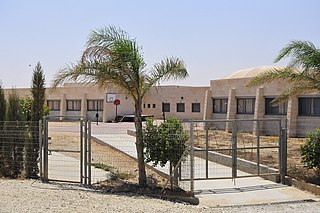
Umm Batin is a Bedouin village in southern Israel. Located in the northern Negev desert, 12 km northeast of Beersheba and adjacent to the highway 60, it falls under the jurisdiction of al-Kasom Regional Council. In 2021 it had a population of 4,705.

<span class="mw-page-title-main">Unrecognized Bedouin villages in Israel</span> Legally ostracized townships in the Negev

Unrecognized Bedouin villages in Israel are rural Bedouin communities in the Negev and the Galilee which the Israeli government does not recognize as legal. They are often referred to as "unrecognized villages".

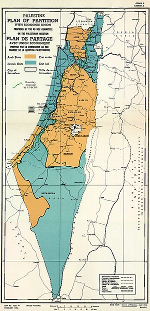
Population shifts in Israel after 1948 refers to the movement of Jewish and Arab populations in the wake of Israeli independence and the outbreak of the 1948 War. Arab villagers who resettled in other locations in Israel after 1948 are often referred to as internally displaced Palestinians. Many fled during the war but later returned to their homes. The Palestinians say that Israelis drove them from out while Israel says most left of their own accord. From 1948 to 1951, mass immigration nearly doubled Israel's Jewish population.
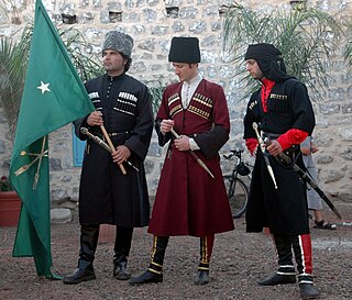
The Jewish-Arab Center (JAC) is a multidisciplinary research institute in the University of Haifa in Haifa, Israel, active since 1972. The head of the center since 2014 is Prof. Rassem Khamaisi.

<span class="mw-page-title-main">Druze in Israel</span> Ethnoreligious minority among Israels Arab citizens

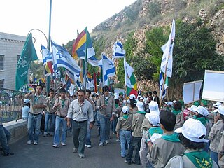
Israeli Druze or Druze Israelis are an ethnoreligious minority among the Arab citizens of Israel.

Joseph Ginat was an Israeli anthropologist, author, political advisor, and soldier.

The Abu Alkian is a tribe living in the Negev desert in southern Israel.

Neve Midbar Regional Council is one of two regional councils formed as a result of a split of Abu Basma Regional Council on November 5, 2012. This regional council is situated in the northwestern Negev desert of Israel and populated by the Negev Bedouin.

<span class="mw-page-title-main">Al-Kasom Regional Council</span> Regional council located in Israel

al-Kasom Regional Council is one of two Negev Bedouin regional councils formed as a result of the split of the Abu Basma Regional Council on November 5, 2012. Al-Kasom regional council is in the northwestern Negev desert of Israel.

<span class="mw-page-title-main">Mixed cities</span> Eight multi-ethnic metropoles in Israel

In Israel, the mixed cities or mixed towns are the eight cities with a significant number of both Israeli Jews and Israeli Arabs. The eight mixed Jewish-Arab cities, defined by the Israel Central Bureau of Statistics as those with more than 10% of the population registered as "Arabs" and more than 10% of the population registered as "Jews", include the following seven Israeli cities: Haifa, Lod, Ramle, Jaffa, Acre, Nof HaGalil, and Ma'alot Tarshiha. Approximately 10% of the Arab citizens of Israel live in these seven cities. The eighth city is Jerusalem, in which the Arab part of the city, East Jerusalem, has been annexed by Israel but is not recognized as such under international law.

References

  1. 1 2 "Housing Transformation within Urbanized Communities: The Arab Palestinians in Israel". Geography Research Forum. 27 February 2016. Archived from the original on 3 October 2019.
  2. "Topic: Mixed Cities in Israel" (PDF). Inter-Agency Task Force on Israeli Arab Issues. 20 June 2014.
  3. 1 2 3 4 Haddad Haj-Yahya, Nasreen (2021). "Statistical Report on Arab Society in Israel: 2021". Israel Democracy Institute.
  4. "Statistical Report on Arab Society in Israel 2021" (PDF). Israel Democracy Institute: 6-8. 17 March 2021.
  5. The Arab Population in Israel. Israel Central Bureau of Statistics. November 2002. p. 3.
  6. "opic: Mixed Cities in Israel" (PDF). Inter-Agency Task Force on Israeli Arab Issues. 20 June 2014.
  7. Shpigel, Noa (August 22, 2017). "This Israeli mixed Arab-Jewish city is in denial". Haaretz.com. Archived from the original on 2018-12-25. Retrieved 2021-07-15.
  8. Sadeh, Shuki (2015-12-25). "A Growing Arab Middle Class Makes a Home in Jewish Cities". Haaretz.com. Retrieved 2022-05-25.: "Some 16,000 Arabs are estimated to be living in 16 cities not officially defined as mixed, or in predominantly Jewish neighborhoods of big cities such as Haifa, Jerusalem and Tel Aviv."
  9. Israel Central Bureau of Statistics, "Settlements".
  10. 1 2 3 4 5 6 7 "Localities and Population, by Population Group, District, Sub-District and Natural Region". Israel Central Bureau of Statistics. 2013. Archived from the original on 13 November 2013. Retrieved 23 December 2013.
  11. 1 2 Lefkowitz, Daniel (2004). Words and Stones: The Politics of Language and Identity in Israel. Oxford University Press. p. 49. ISBN   9780198028437.
  12. "Regional Statistics". Israel Central Bureau of Statistics. Retrieved 22 February 2023.
  13. "Topic: Mixed Cities in Israel" (PDF). Inter-Agency Task Force on Israeli Arab Issues. 20 June 2014.
  14. "Topic: Mixed Cities in Israel" (PDF). Inter-Agency Task Force on Israeli Arab Issues. 20 June 2014.
  15. "Tel Aviv profile: 2019" (PDF). Israel Central Bureau of Statistics. 31 December 2019.
  16. 1 2 "The Arab Population in Israel 2008" (PDF). Archived from the original (PDF) on 2010-04-01. Retrieved 2010-04-03.
  17. Kimmerling, Baruch (2003), Politicide: Ariel Sharon's War Against the Palestinians, Verso, p. 28, ISBN   978-1-84467-532-6
  18. 1 2 "The Fate of Abandoned Arab Villages, 1965-1969" by Aron Shai (History & Memory - Volume 18, Number 2, Fall/Winter 2006, pp. 86-106)