
Nahf is an Arab town in the Northern District of Israel. It is located in between the lower and upper Galilee, about 23 kilometres (14 mi) east of Acre. In 2022 it had a population of 13,717. Archaeologists believe that the area was an important center for viticulture in the Hellenistic period and possibly the Early Bronze Age IB period.

Al-Ruways, was a Palestinian Arab village on a rocky hill located 12 kilometers (7.5 mi) southeast of Acre and south of the village of al-Damun. Its population in 1945 was 330. Al-Ruways was depopulated following its capture by Israeli forces during the 1948 Arab-Israeli War.

Sakhnin is an Arab city in Israel's Northern District. It is located in the Lower Galilee, about 23 kilometres (14 mi) east of Acre. Sakhnin was declared a city in 1995. In 2022 its population was 33,188, mostly Muslim with a sizable Christian minority.

Dayr al-Qassi or Deir el-Qasi, was a Palestinian Arab village located 26 km northeast of the city of Acre, which was depopulated during 1948 Arab-Israeli war.

Tarbikha, was a Palestinian Arab village. It was located 27 kilometres northeast of Acre in the British Mandate District of Acre that was captured and depopulated by the Israel Defense Forces during the 1948 Arab-Israeli war. The inhabitants of this village were, similar to the inhabitants of Southern Lebanon, Shia Muslims.

Umm al-Faraj, was a Palestinian village, depopulated in 1948.

Abu Snan is an Arab village and locality in the Galilee, part of the Northern District of Israel. With an area of 4,750 dunams. It acquired recognition as an independent local council in 1964. It is a religiously-mixed village of Arabs, with a Muslim majority, along with sizable Druze and Arab-Christian minorities. According to the Israel Central Bureau of Statistics (CBS), in 2022 Abu Snan had a total population of 14,687.

Deir Hanna is a local council in the Northern District of Israel, located on the hills of the Lower Galilee, 23 kilometres (14 mi) southeast of Acre. In 2022 it had a population of 10,747. Approximately 90% of Deir Hanna's inhabitants are Arab Muslims and the remaining 10% are Arab Christians.

Bayt Jann is a Druze village on Mount Meron in northern Israel. At 940 meters above sea level, Bayt Jann is one of the highest inhabited locations in the country. In 2022 it had a population of 12,433.
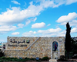
Fassouta is a Christian Arab village in the Galilee. It is located on the northwestern slopes of Mount Meron, south of the Lebanese border. In 2022 it had a population of 3,255, nearly all of whom are Melkite Christian Arabs.
Julis is a Druze village and local council in the Northern District of Israel. In 2022 it had a population of 6,738.

Yarka, officially Yirka, is a Druze village and local council in the Northern District of Israel. In 2019 it had a population of 17,171, 98.8% of them members of the Druze community, with a small Muslim (1.0%) and Christian (0.1%) minorities.

Arraba, also known as 'Arrabat al-Battuf, is an Arab city in Israel. It is located in the Lower Galilee in the Northern District, within Sakhnin valley, adjacent to Sakhnin and Deir Hanna, and climbing a bit on Yodfat range to its south, while also owning some lands south of that in the Beit Netofa Valley to the north of Nazareth area. Arraba attained local council status in 1965, and city status in 2016. In 2022, its population was 27,115.

Hurfeish is a Druze town in the Northern District of Israel. In 2022 it had a population of 6,639.

Yanuh-Jat is an Israeli Druze village and local council in the Northern District of Israel, northeast of Acre, consisting of the villages of Yanuh and Jat, which merged in 1990. In 2022 it had a population of 6,930, all members of the Druze community.

Ga'aton is a kibbutz in northern Israel. Located in the western Galilee, it falls under the jurisdiction of Mateh Asher Regional Council. In 2022 it had a population of 725.

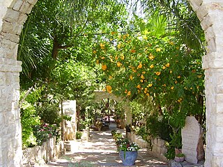
Mi'ilya, also called Mi'elya, is an Arab local council in the western Galilee in the Northern District of Israel. Its name during the Kingdom of Jerusalem era in Galilee was Castellum Regis. In 2022 it had a population of 3,281, all of whom are Melkite Greek Catholics. The town is located immediately to the northwest of Ma'alot-Tarshiha.

Kisra-Sumei is a town and local council in the western Galilee in the Northern District of Israel. In 2022 it had a population of 9,223. In April 2019, 95% of the population were Israeli Arabs of the Druze community, with a small Christian minority. The town has a Druze holy place as well as a statue to the Druze leader and Syrian nationalist revolutionary Sultan al-Atrash.
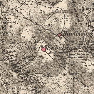
Sabalan was a Palestinian Arab village in the Safad Subdistrict, located 15.5 kilometers (9.6 mi) northwest of Safad. It stood at an elevation of 800 meters (2,600 ft) above sea level overlooking the Druze village of Hurfeish. In 1945, Sabalan had a population of 70. It was depopulated during the 1948 Palestine War.

Al-Mansura was a Palestinian Arab village in the Tiberias Subdistrict. It was depopulated during the 1947–1948 Civil War in Mandatory Palestine on May 10, 1948. It was located 16 kilometres northwest of Tiberias.


