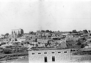
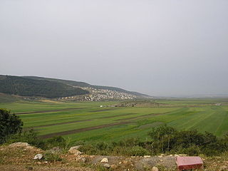
Safsaf was a Palestinian village 9 kilometres northwest of Safed, present-day Israel. Its villagers fled to Lebanon after the Safsaf massacre in October 1948, during the 1948 Arab–Israeli War.
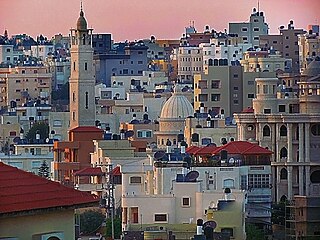
Tayibe, also spelled Taibeh or Tayiba, is an Arab city in central Israel, 12 km (7 mi) north east of Kfar Saba. Part of the Triangle region, in 2022 it had a population of 46,020. Its citizens are Muslims and Christians.

Kiryat Tiv'on is a town in the Haifa District of Israel, in the hills between the Zvulun (Zebulon) and Jezreel valleys. Kiryat Tiv'on is located 15 kilometres (9.3 mi) southeast of Haifa, on the main road to Nazareth. Kiryat Tiv'on is the result of the municipal merger of several older settlements, Tiv'on, Elro'i, Kiryat Haroshet and Kiryat Amal. On the outskirts of Tiv'on is a Bedouin township called Basmat Tab'un. In 2022 it had a population of 19,130.
Julis is a Druze village and local council in the Northern District of Israel. In 2022 it had a population of 6,738.

Bir al-Maksur or Beer el-Maksura is an Arab Bedouin local council in the Northern District of Israel located 15 kilometres (9.3 mi) north-west of Nazareth. In 2022 its population was 10,175. The villagers belong to the Arab el-Hujeirat Bedouin tribe, settled there in the 1950s.

Eilabun is an Arab Christian village located in the Beit Netofa Valley around 15 kilometres south-west of Safed in northern Galilee between Nazareth and the Sea of Galilee. It had a population of 5,799 in 2022, which is predominantly Christian (70.5%). In 1973, Eilabun was granted local council status by the Israeli government.

Qira was a Palestinian Arab village, located 23 kilometers southeast of Haifa. It was locally referred to as Qira wa Qamun.

Indur was a Palestinian village, located 10.5 kilometres (6.5 mi) southeast of Nazareth. Its name preserves that of ancient Endor, a Canaanite city state thought to have been located 1 kilometre (0.62 mi) to the northeast. The village was depopulated during the 1948 Arab–Israeli War and its inhabitants became refugees, some of whom were internally displaced. In Israel today, there are a few thousand internally displaced Palestinians who hail from Indur, and continue to demand their right of return.
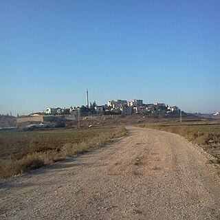
Tayasir is a Palestinian village in the Tubas Governorate of the Palestinian Authority, in the northern West Bank. It is located 3 kilometers northeast of Tubas and 22 kilometers northeast of Nablus. Nearby localities include al-Aqabah to the east, al-Bikai'a to the northeast, Salhab to the north, 'Aqqaba to the west and ath-Thaghra to the southwest. According to the Palestinian Central Bureau of Statistics (PCBS), Tayasir had a population of 2,489 in 2007 and a population of 2,878 by 2017.
Ein Mahil is an Arab local council in the Northern District of Israel, located about five kilometers north-east of Nazareth. It was declared a local council in 1964. In 2022 it had a population of 13,931, the majority of which are Muslims.
Bu'eine Nujeidat is an Arab local council in the Northern District of Israel. Made up of two villages, Bu'eine and Nujeidat, they merged in 1987 and were recognized as one local council in 1996. In 2022 its population was 10,289, the majority of which is Muslim.
Rumana is an Arab village in northern Israel. Located near Nazareth, it falls under the jurisdiction of al-Batuf Regional Council. In 2022 its population was 1,276.

Al-Attara is a Palestinian village in the Jenin Governorate of Palestine, in the northwestern area of the West Bank, located 15 kilometers southwest of Jenin. According to the Palestinian Central Bureau of Statistics, the village had a population of 1,072 inhabitants in mid-year 2006 and 1,244 by 2017.

Beit Ta'mir is a Palestinian village located six kilometers southeast of Bethlehem.The town is in the Bethlehem Governorate central West Bank. According to the Palestinian Central Bureau of Statistics, the village had a population of 1,596 in 2017. The village is named after the 'Arab al-Ta'mira Bedouin tribe of the Bethlehem area, and along with Za'atara, Hindaza, Tuqu', Khirbet al-Deir, Nuaman, Ubeidiya and al-Asakra forms the 'Arab al-Ta'mira village cluster.

Ga'aton is a kibbutz in northern Israel. Located in the western Galilee, it falls under the jurisdiction of Mateh Asher Regional Council. In 2022 it had a population of 725.

Sallama is a Bedouin village in northern Israel. Located in the Galilee near the Tzalmon Stream, it falls under the jurisdiction of Misgav Regional Council. In 2022 its population was 3,552. The village was recognized by the state in 1976.
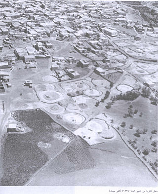
Kafr Sabt was a Palestinian Arab village of nearly 500 situated on a sloping plain in the eastern Lower Galilee located 10.5 kilometers (6.5 mi) southwest of Tiberias. It was depopulated in 1948.

Harrawi was a Palestinian Arab village in the Safad Subdistrict. It was depopulated during the 1948 Arab-Israeli War on May 25, 1948, by the Palmach's First Battalion of Operation Yiftach. It was located 18 km northeast of Safad.

Al-Mansura was a Palestinian Arab village in the Safad Subdistrict. It was located 31 kilometres (19 mi) northeast of Safad on the Banyas River, to the south of what is now Dafna.

Al-Samakiyya was a Palestinian Arab village in the Tiberias Subdistrict. It was depopulated during the 1947–1948 Civil War in Mandatory Palestine on May 4, 1948, under Operation Matateh. It was located 11 km northeast of Tiberias, near the Wadi al-Wadabani. The village was located at Tel Hum, which has been identified with Capernaum.

