

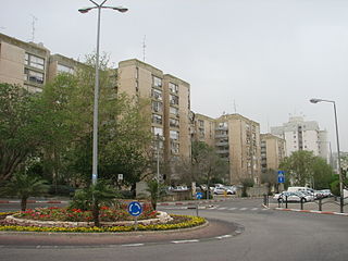
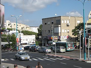
Halisa (Hebrew : חליסה; Arabic : الحليصة), also spelled Khalisa, is a neighborhood in the southeastern part of Haifa in northern Israel. It is located in the administrative region of Nave Sha'anan-Izraeliya, on the edge of the Mount Carmel. [1]
Halisa (Hebrew : חליסה; Arabic : الحليصة), also spelled Khalisa, is a neighborhood in the southeastern part of Haifa in northern Israel. It is located in the administrative region of Nave Sha'anan-Izraeliya, on the edge of the Mount Carmel. [1]
Halisa lies at an altitude of less than 100 meters, about 2 kilometers southeast of the center of the lower town. It is bordered to the south by the Nave Sha'anan district, to the west by Nachala, and to the north by the central part of the city around Kibbutz Galujot Street. Further to the north, industrial areas are already spread around the port of Haifa. It occupies a position on the northern edge of the slopes of Carmel. To the west, this settlement slope is bounded by the valley of wadi Nahal Giborim. The main traffic axis is ha-Giborim Street. [2] [3] The population is Arab, with a Jewish minority.
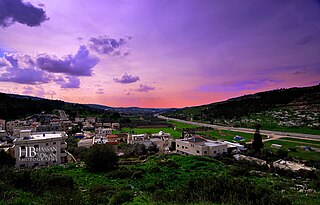
Halisa features the oldest settlement centers in this area. The Rushmiya Bridge, built in 1927 under the mayor Hassan Bey Shukri, leads over the Nahal Giborim wadi. From an engineering point of view, the concrete structure represented one of the most modern buildings of this type in Mandatory Palestine at the time. Its arc had a span of 30 meters. During the first Arab-Israeli war, or the previous period of the civil war in Palestine in 1948, fighting between Jews and Arabs took place here. Later, the even newer Gdud 22 Bridge was built near it. [4]

Haifa is the third-largest city in Israel—after Jerusalem and Tel Aviv—with a population of 290,306 in 2022. The city of Haifa forms part of the Haifa metropolitan area, the third-most populous metropolitan area in Israel. It is home to the Baháʼí Faith's Baháʼí World Centre, and is a UNESCO World Heritage Site and a destination for Baháʼí pilgrimage.

Mount Carmel, also known in Arabic as Mount Mar Elias, is a coastal mountain range in northern Israel stretching from the Mediterranean Sea towards the southeast. The range is a UNESCO biosphere reserve. A number of towns are situated there, most notably Haifa, Israel's third largest city, located on the northern and western slopes.

The Battle of Haifa, also known as the Fall of Haifa, and called by the Jewish forces Operation Bi'ur Hametz, was a Haganah operation carried out on 21–22 April 1948 and a major event in the final stages of the civil war in Palestine, leading up to the 1948 Arab-Israeli War. The objective of the operation was the capture of the Arab neighborhoods of Haifa. The operation formed part of the 1948 Palestinian expulsion and flight, with approximately 15,000 Arab residents being displaced between April 21–22, and with only 4,000 remaining in the city by mid-May from a pre-conflict population of approximately 65,000.

El Wad is an Epipalaeolithic archaeological site in Mount Carmel, Israel. The site has two components: El Wad Cave, also known as Mugharat el-Wad or HaNahal Cave ; and El Wad Terrace, located immediately outside the cave.
Nave Sha'anan is a large residential neighborhood in eastern Haifa, Israel that extends from the lower inclines of Mount Carmel to midway across its slopes. The main campus of the Technion university is located in the outskirts of Nave Sha'anan.

Wadi Salib is a primarily Palestinian neighbourhood located in downtown Haifa, Israel, on the lower northeastern slope of Mount Carmel, between the Hadar HaCarmel and the city's historic center and CBD.

Israeli coastal plain is the Israeli segment of the Levantine coastal plain of the Mediterranean Sea, extending 187 kilometres (116 mi) north to south. It is a geographical region defined morphologically by the sea, in terms of topography and soil, and also in its climate, flora and fauna. It is narrow in the north and broadens considerably towards the south, and is continuous, except the short section where Mount Carmel reaches almost all the way to the sea. The Coastal Plain is bordered to the east by – north to south – the topographically higher regions of the Galilee, the low and flat Jezreel Valley, the Carmel range, the mountains of Samaria, the hill country of Judea known as the Shephelah, and the Negev Mountains in the south. To the north it is separated from the coastal plain of Lebanon by the cliffs of Rosh HaNikra, which jut out into the sea from the Galilee mountains, but to the south it continues into the Egyptian Sinai Peninsula.

Denia is a district of Haifa, Israel, located on Mount Carmel. Denia and its associated neighborhoods capture the southernmost part of Haifa's jurisdiction area, which is also the highest-elevated topographically, and make up the city's altogether most affluent as well as least densely populated residential borough, with a population count of slightly more than 11,000 in 2008. It lies approximately 5 kilometers in a beeline from downtown Haifa and is crossed by Aba Hushi Avenue, which has made the district sometimes be referred to as the "Aba Hushi Axis". It is bordered by Nesher to the east, Nave Sha'anan to northeast, Ahuza to the north, Tirat Carmel to the west and the Mount Carmel National Park, among which portions of Hof HaCarmel Regional Council are interspersed, to the south. The University of Haifa's main campus, with its identifiable Eshkol Tower, is located in the borough.

Haifa Center–HaShmona railway station is an Israel Railways passenger station situated on the coastal railway main line and serves the City of Haifa.

Hadar HaCarmel is a district of Haifa, Israel. Located on the northern slope of Mount Carmel between the upper and lower city overlooking the Port of Haifa and Haifa Bay, it was once the commercial center of Haifa.
Wadi Ara or Nahal 'Iron, is a valley and its surrounding area in Israel populated mainly by Arab Israelis. The area is also known as the "Northern Triangle".
The Israeli city of Haifa is divided into nine quarters, which are subdivided into subquaters, which are further divided into neighborhoods.

The history of Haifa dates back before the 3rd century BCE. Since then it has been controlled by several civilizations, including the Canaanites, Persians, Romans, Byzantines, Muslims, Crusaders, Kurds, the Mamluks, the Ottoman Turks and the British; currently it is a major city in Israel.

Wadi Nisnas is a predominantly Arab neighborhood in the city of Haifa, Israel, with a population of about 8,000 inhabitants.
The Manasseh Hills or hill country of Manasseh, directly derived from Hebrew: Menashe Heights, called Bilad ar-Ruha in Arabic, meaning "Land of Winds", is a geographical region in northern Israel, located on the Carmel Range, between Mount Carmel and Mount Amir/Umm al-Fahm.
Merkaz HaCarmel also called Carmel Merkazi or in English, Carmel Center, is a neighborhood, and cultural and recreation area on the slopes of Mount Carmel in Haifa, Israel.

Montefiore is a neighborhood in the center of Tel Aviv, Israel.

Nahal Katlav is a valley in the Judean Mountains of Israel.

Emeq HaArazim is a valley in the Judean Mountains of Israel.
Abbas is a neighborhood in the city of Haifa in northern Israel. It is located in the administrative region of Hadar, on the edge of the Mount Carmel. neighborhoods such as German Colony, Wadi Nisnas and Abbas, are largely Arab Christian.