Cahuilla County, California

Last updated

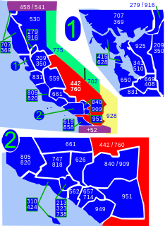
Cahuilla County was a proposed county initiated by the residents of eastern Riverside County, California in the 1980s. It was named after the Cahuilla people, being the homeland of the Native American Tribe for over 2,000 years. [1]

County (United States) Subdivision used by most states in the United States of America

In the United States, a county is an administrative or political subdivision of a state that consists of a geographic region with specific boundaries and usually some level of governmental authority. The term "county" is used in 48 U.S. states, while Louisiana and Alaska have functionally equivalent subdivisions called parishes and boroughs, respectively.

Riverside County, California County in California, United States

Riverside County is one of 58 counties in the U.S. state of California. As of the 2010 census, the population was 2,189,641, making it the fourth-most populous county in California and the 11th-most populous in the United States. The name was derived from the city of Riverside, which is the county seat.

California U.S. state in the United States

California is a state in the Pacific Region of the United States. With 39.6 million residents across a total area of about 163,696 square miles (423,970 km2), California is the most populous U.S. state and the third-largest by area. The state capital is Sacramento. The Greater Los Angeles Area and the San Francisco Bay Area are the nation's second- and fifth-most populous urban regions, with 18.7 million and 9.7 million residents respectively. Los Angeles is California's most populous city, and the country's second-most populous, after New York City. California also has the nation's most populous county, Los Angeles County, and its largest county by area, San Bernardino County. The City and County of San Francisco is both the country's second-most densely populated major city after New York City and the fifth-most densely populated county, behind only four of the five New York City boroughs.

Contents

The proposed county would have included the Coachella Valley including the cities of:

Coachella Valley valley in southern California

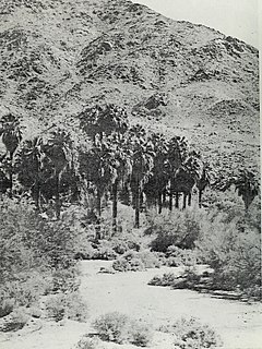
The Coachella Valley is a desert valley in Southern California that extends approximately 45 mi (72 km) in Riverside County southeast from the San Bernardino Mountains to the northern shore of the Salton Sea. It is the northernmost extent of the vast trough that includes the Salton Sea, the Imperial Valley and the Gulf of California. It is approximately 15 mi (24 km) wide along most of its length, bounded on the west by the San Jacinto Mountains and the Santa Rosa Mountains and on the north and east by the Little San Bernardino Mountains. The San Andreas Fault crosses the valley from the Chocolate Mountains in the southeast corner and along the centerline of the Little San Bernardinos. The fault is easily visible along its northern length as a strip of greenery against an otherwise bare mountain.

Palm Springs, California City in California, United States

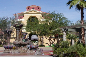
Palm Springs is a desert resort city in Riverside County, California, United States, within the Coachella Valley. It is located approximately 55 mi (89 km) east of San Bernardino, 107 mi (172 km) east of Los Angeles, 123 mi (198 km) northeast of San Diego, and 268 mi (431 km) west of Phoenix, Arizona. The population was 44,552 as of the 2010 census. Palm Springs covers approximately 94 square miles (240 km2), making it the largest city in Riverside County by land area.

Desert Hot Springs, California City in California, United States

Desert Hot Springs, also known as DHS, is a city in Riverside County, California, United States. The city is located within the Coachella Valley geographic region, sometimes referred to as the Desert Empire. The population was 25,938 at the 2010 census, up from 16,582 at the 2000 census. The city has undergone rapid development and high population growth since the 1970s, when there were 2,700 residents.

Cathedral City, California City in California, United States

Cathedral City, colloquially known as "Cat City", is a city in Riverside County, California. Its population was 51,200 at the 2010 census. Situated between Palm Springs and Rancho Mirage, the city has the second largest population of the nine cities in the Coachella Valley of Southern California, after Indio.

The ballot measure was ultimately defeated.

Boundaries

The eastern border of the county would have included the current Riverside County's existing eastern county-line north and south of Blythe along the Colorado River and Arizona border. The western border of the county (either the city limits of Banning/Beaumont or near Cabazon) would have included the mountain community of Idyllwild in the San Jacinto Mountains, east of the Hemet area which would have remained in Riverside County.

Colorado River major river in the western United States and Mexico

The Colorado River is one of the principal rivers in the Southwestern United States and northern Mexico. The 1,450-mile-long (2,330 km) river drains an expansive, arid watershed that encompasses parts of seven U.S. and two Mexican states. Starting in the central Rocky Mountains of Colorado, the river flows generally southwest across the Colorado Plateau and through the Grand Canyon before reaching Lake Mead on the Arizona–Nevada border, where it turns south toward the international border. After entering Mexico, the Colorado approaches the mostly dry Colorado River Delta at the tip of the Gulf of California between Baja California and Sonora.

Arizona U.S. state in the United States

Arizona is a state in the southwestern region of the United States. It is also part of the Western and the Mountain states. It is the sixth largest and the 14th most populous of the 50 states. Its capital and largest city is Phoenix. Arizona shares the Four Corners region with Utah, Colorado, and New Mexico; its other neighboring states are Nevada and California to the west and the Mexican states of Sonora and Baja California to the south and southwest.

Banning, California City in California, United States

Banning is a city in Riverside County, California, United States. The population was 29,603 at the 2010 census. It is situated in the San Gorgonio Pass, also known as Banning Pass. It is named for Phineas Banning, stagecoach line owner and the "Father of the Port of Los Angeles."

Proponents argued at the time that the eastern Colorado Desert and Peninsular Ranges mountain areas were distinct from the western urban basin area, commonly known as the Inland Empire, and they were too far removed from the county seat at Riverside, about 70 miles from the possible Cahuilla county seat of Indio.

Colorado Desert desert in California, United States

California's Colorado Desert is a part of the larger Sonoran Desert. It encompasses approximately 7 million acres (28,000 km2), including the heavily irrigated Coachella and Imperial valleys. It is home to many unique flora and fauna.

Peninsular Ranges

The Peninsular Ranges are a group of mountain ranges that stretch 1,500 km (930 mi) from Southern California to the southern tip of the Baja California Peninsula; they are part of the North American Coast Ranges, which run along the Pacific Coast from Alaska to Mexico. Elevations range from 500 to 10,834 feet.

Riverside, California City in California

Riverside is a city in, and the county seat of, Riverside County, California, United States, located in the Inland Empire metropolitan area. It is named for its location beside the Santa Ana River. It is the most populous city in the Inland Empire and in Riverside County, and is located about 55 miles (89 km) east of downtown Los Angeles. It is also part of the Greater Los Angeles area. Riverside is the 59th most populous city in the United States and 12th most populous city in California. As of the 2010 Census, Riverside had a population of 303,871.

See also

Related Research Articles

Coachella, California City in California, United States

Coachella is a city in Riverside County, California; it is the easternmost city in the region known as the Coachella Valley. It is 28 miles (45 km) east of Palm Springs, 80 miles (130 km) east of Riverside, and 130 miles (210 km) east of Los Angeles.

Indio, California City in California, United States

Indio is a city in Riverside County, California, United States, located in the Coachella Valley of Southern California's Colorado Desert region. It lies 23 miles (37 km) east of Palm Springs, 75 miles (121 km) east of Riverside, 127 miles (204 km) east of Los Angeles, and 148 miles northeast of San Diego. The word Indio is Spanish for Indian.

Palm Desert, California City in California, United States

Palm Desert is a city in Riverside County, California, United States, in the Coachella Valley, approximately 14 miles (23 km) east of Palm Springs, 121 miles (194 km) northeast of San Diego and 122 miles (196 km) east of Los Angeles. The population was 48,445 at the 2010 census, up from 41,155 at the 2000 census. The city was one of the state's fastest growing in the 1980s and 1990s, beginning with 11,801 residents in 1980, doubling to 23,650 in 1990, 35,000 in 1995, and nearly double its 1990 population by 2000. A major center of growth in the Coachella Valley, Palm Desert is a popular retreat for "snowbirds" from colder climates, who swell its population by an estimated 31,000 each winter. In the past couple of years Palm Desert has seen more residents become "full-timers", mainly from the coasts and urban centers of California, who have come for both affordable and high-valued home prices.

Sonoran Desert North American desert

The Sonoran Desert is a North American desert which covers large parts of the Southwestern United States in Arizona and California and of Northwestern Mexico in Sonora, Baja California, and Baja California Sur. It is the hottest desert in Mexico. It has an area of 260,000 square kilometers (100,000 sq mi). The western portion of the United States–Mexico border passes through the Sonoran Desert.

Low Desert

The Low Desert is a common name for any desert in California that is under 2,000 feet (609.6m) in altitude. These areas include, but are not exclusive to, the Colorado Desert and Yuha Desert, in the Southern California portion of the Sonoran Desert. These areas are distinguished in biogeography from the adjacent northern High Desert or Mojave Desert by latitude, elevation, animal life, climate, and native plant communities.

California State Route 111 highway in California

State Route 111 is a state highway in the U.S. state of California. It is the main north-south route and retail corridor through the Coachella Valley, a part of the Colorado Desert in the southeastern corner of the state and a famous resort destination. It also runs through the Imperial Valley, and along the eastern shore of the Salton Sea. Its southern terminus is at the U.S.-Mexico border crossing in Calexico, and its northern terminus is at Interstate 10 at Whitewater.

Little San Bernardino Mountains mountain range in Southern California, United States

The Little San Bernardino Mountains are a short mountain range of the Transverse Ranges, located in southern California in the United States. They extend for approximately 40 mi (64 km) southeast from the San Bernardino Mountains through San Bernardino and Riverside Counties to near the northeast edge of the Salton Sink and Salton Sea.

Cahuilla Native American people

The Cahuilla, also known as ʔívil̃uqaletem or Ivilyuqaletem, are a Native American people of the inland areas of southern California. Their original territory included an area of about 2,400 square miles (6,200 km2). The traditional Cahuilla territory was near the geographic center of Southern California. It was bounded to the north by the San Bernardino Mountains, to the south by Borrego Springs and the Chocolate Mountains, to the east by the Colorado Desert, and to the west by the San Jacinto Plain and the eastern slopes of the Palomar Mountains.

Area codes 760 and 442 Area codes for southern and eastern California

Area code 760 is a California telephone area code that was split from area code 619 on March 22, 1997. Area code 442 is an overlay of 760 that became effective on November 21, 2009. It encompasses much of the southeastern and southernmost portions of California. The area includes Imperial, Inyo, and Mono counties, as well as portions of San Diego, Riverside, San Bernardino, Los Angeles and Kern counties.

The Agua Caliente Band of Cahuilla Indians of the Agua Caliente Indian Reservation is a federally recognized tribe of the Cahuilla, located in Riverside County, California. They inhabited the Coachella Valley desert and surrounding mountains between 5000 BCE and 500 AD. With the establishment of the reservations, the Cahuilla were officially divided into 10 sovereign nations, including the Agua Caliente Band.

Corn Springs United States historic place

Corn Springs is a palm oasis situated in the Chuckwalla Mountains of the Colorado Desert in Riverside County, California, United States, seventeen miles southeast of Desert Center. Native Americans relied on the springs, and they engraved many petroglyphs on the rocks in the area. In the late 19th century, miners in the area also relied on the springs, and they established the Corn Springs Mining District in 1897.

Riverside County Fair and National Date Festival fair held in Indio, California

The Riverside County Fair and National Date Festival takes place in Indio, California. Since 1947 the annual festival has been held to celebrate the Date Palm harvest in the Coachella Valley. The event is held in February on the Riverside County Fairgrounds.

The Bradshaw Trail, nicknamed the Gold Road at one time, is an historic overland stage route in Southern California which originally connected San Bernardino, California to gold fields in La Paz, Arizona Territory some 5 miles northeast of Ehrenberg, and the road to the mining districts of Central Arizona Territory, near Wickenburg and Prescott. In later years it was the first road connecting Riverside County to the Colorado River.

Indio Hills

The Indio Hills are a low mountain range in the Colorado Desert, near Indio in eastern Riverside County, southern California.

SunLine Transit Agency

SunLine Transit Agency, a transit operator in Riverside County, California, is a transit agency providing bus service in the Coachella Valley area and Riverside–Downtown Area during Peak Hours Only.

New Arena at Agua Caliente planned arena in Palm Springs, California

New Arena at Agua Caliente is the tentative name of a planned multi-purpose 10,000 seat indoor arena to be built in Palm Springs, California. It would be constructed on part of the parking lots of the Spa Resort Casino and be owned by the Agua Caliente Band of Cahuilla Indians with Oak View Group as the arena operator. Its primary use would be as the home of the Palm Springs AHL team of the American Hockey League (AHL). It would also hold other events via a contract with Live Nation and have an adjoining facility that will serve as a year-round community gathering space as well as the training center for the AHL team. Groundbreaking and construction on the arena is expected to begin in February 2020, with completion by the fall of 2021.

References

  1. "California Indians and Their Reservations. SDSU Library and Information Access. (retrieved 12 Dec 2009) Archived June 13, 2010, at the Wayback Machine