Cairns of Coll

Last updated

View of the skerries around Eilean Mor from the vicinity of Sgeir Stangail View west across skerries to the open sea - geograph.org.uk - 517760.jpg
View of the skerries around Eilean Mòr from the vicinity of Sgeir Stangail

The Cairns of Coll refers primarily to a region of rocky outcrops in shallow waters extending from the north end of the Island of Coll in the Inner Hebrides of Scotland. The extension is about 1.1 miles from shore, 1.6 if the Cairns of Coll Rocks 0.5 miles further are to be included. The outcrops of the Cairns are too small to be inhabited. The swift and unpredictable tidal currents between them make navigation hazardous to boats. They are rich in abundant and varied marine life, including the marine mammals.

Contents

In 2014, the Cairns of Coll were purchased for £300,000 by author Alexander McCall Smith, who expressed an intent to deed the islands back to the nation as a wildlife sanctuary on his death. [1]

Geography

Some several dozen sgeiran (skerries) are arranged in groups around three islets. [2] The largest group, that around Eilean Mòr, comprises also about 40 skerries. Only the largest have been named. They include Sgeir Ghlas, Sgeir Leathan, Sgeir Eoin Bhàin, Sgeiran nan Cuiseag, and Sgeir an Otraich. To the northeast is Eag na Maoile and about 15 skerries. To the northwest of it, and north of Eilean Mòr, is Sùil Ghorm, which has a lighthouse, and about 15 skerries. There are more outcrops between Eilean Mòr and Coll. Seen as real estate, the package includes or once included a house on the north coast of Coll.

The light is placed on the outermost buildable land of the Cairns, but not on the outermost outcrop. A half-mile further out is a group of two outcrops barely breaking the surface at high tide, an extreme hazard. In the nautical books and charts of the 19th and earlier 20th centuries these were named the Cairns of Coll. It is not certain whether the name referred only to the two rocks or was a title for the whole group. In the later 20th century some nautical documents began to refer to them as the Cairns of Coll Rocks, to be considered as being in the Cairns of Coll. Otherwise the meaning must be gleaned from the context.

A navigational work of the late 19th century reports: "The passage between the Cairns of Coll and Suil Ghorm is half a mile across, and affords a deep clear channel, though it should never be used except by persons possessing local knowledge, as the tides run with considerable velocity." [3] "Persons possessing local knowledge" refers to a maritime pilot, who was employed ubiquitously for navigation in coastal and inland waters in the age before electronic navigation. Today's maritime road around Coll lies well to the north of the Cairns of Coll Rocks.

Lighthouse

Cairns of Coll Light
Suil Ghorm - geograph.org.uk - 235478.jpg
Cairns of Coll
Location Coll, Argyll and Bute, United Kingdom OOjs UI icon edit-ltr-progressive.svg
Coordinates 56°42′16″N6°26′43″W / 56.704466°N 6.445381°W / 56.704466; -6.445381
Tower
Constructed1909  OOjs UI icon edit-ltr-progressive.svg
Designed by David Alan Stevenson, Charles Alexander Stevenson   OOjs UI icon edit-ltr-progressive.svg
Constructionmetal  OOjs UI icon edit-ltr-progressive.svg
Height7 m (23 ft)  OOjs UI icon edit-ltr-progressive.svg
Shapecylindrical tower with balcony and lantern [4]
Markingswhite (tower), white (lantern)  OOjs UI icon edit-ltr-progressive.svg
Power sourcesolar power  OOjs UI icon edit-ltr-progressive.svg
Operator Northern Lighthouse Board   OOjs UI icon edit-ltr-progressive.svg
Light
Focal height23 m (75 ft)  OOjs UI icon edit-ltr-progressive.svg
Characteristic Fl W 12s  OOjs UI icon edit-ltr-progressive.svg

Being a fatal hazard to unwary deep-water vessels, the Cairns of Coll are marked by a beacon constructed on Sùil Ghorm, called variously the Coll, Cairns of Coll, or Sùil Ghorm light, lighthouse, or beacon. Work has been done on it repeatedly for varying lengths of time. The year of first construction is 1909. [5] It is a design of David Alan Stevenson and Charles Alexander Stevenson who were engineers of the noted Stevenson family, which worked for generations for the Northern Lighthouse Board. The lighthouse is a metal tower with gallery and lantern painted white, powered by solar panel, emits a white flash every 12 seconds and is operated by Northern Lighthouse Board.

See also

Related Research Articles

<span class="mw-page-title-main">Argyll</span> Historic county in Scotland

Argyll, sometimes called Argyllshire, is a historic county and registration county of western Scotland.

The Treshnish Isles are an archipelago of small islands and skerries, lying west of the Isle of Mull, in Scotland. They are part of the Inner Hebrides. Trips to the Treshnish Isles operate from Ulva Ferry, Tobermory, Ardnamurchan and Tiree.

The Flannan Isles or alternatively, the Seven Hunters are a small island group in the Outer Hebrides of Scotland, approximately 32 kilometres west of the Isle of Lewis. They may take their name from Saint Flannan, the 7th century Irish preacher and abbot.

<span class="mw-page-title-main">Hyskeir</span> Islet in Scotland

Hyskeir or Heyskeir is a low-lying rocky islet in the Inner Hebrides, Scotland. The Hyskeir Lighthouse marks the southern entrance to the Minch.

<span class="mw-page-title-main">The Minch</span> Strait in Scotland

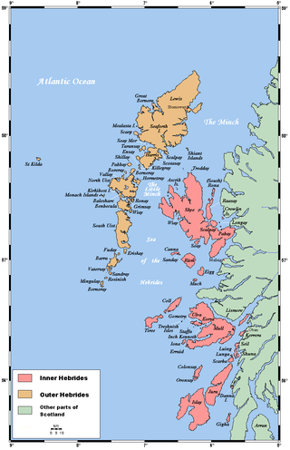
The Minch is a strait in north-west Scotland that separates the mainland from Lewis and Harris in the Outer Hebrides. It was known as Skotlandsfjörð in Old Norse.

<span class="mw-page-title-main">Northern Lighthouse Board</span> Non-departmental public body in the UK

The Northern Lighthouse Board (NLB) is the general lighthouse authority for Scotland and the Isle of Man. It is a non-departmental public body responsible for marine navigation aids around coastal areas.

<span class="mw-page-title-main">Sule Skerry</span> Remote skerry in the North Atlantic off the north coast of Scotland

Sule Skerry is a remote skerry in the North Atlantic off the north coast of Scotland.

Skerryvore is a remote island that lies off the west coast of Scotland, 11 nautical miles southwest of Tiree. Skerryvore Lighthouse is located on these rocks, built with some difficulty between 1838 and 1844 by Alan Stevenson.

<span class="mw-page-title-main">Ross-shire</span> Historic county in Scotland

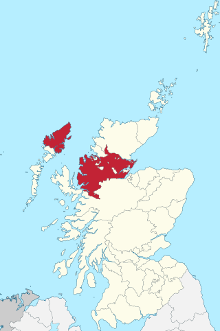
Ross-shire is a historic county in the Scottish Highlands. The county borders Sutherland to the north and Inverness-shire to the south, as well as having a complex border with Cromartyshire – a county consisting of numerous enclaves or exclaves scattered throughout Ross-shire's territory. Ross-shire includes most of Ross along with Lewis in the Outer Hebrides. Dingwall is the traditional county town. The area of Ross-shire is based on that of the historic province of Ross, but with the exclusion of the many enclaves that form Cromartyshire.

Lunga is one of the Slate Islands in the Firth of Lorn in Argyll and Bute, Scotland. The "Grey Dog" tidal race, which runs in the sea channel to the south, reaches 8 knots (15 km/h) in full flood. The name "Lunga" is derived from the Old Norse for "isle of the longships', but almost all other place names are Gaelic in origin. The population was never substantial and today the main activity is an adventure centre on the northern headland of Rubha Fiola. The surrounding seas are fished for prawns and scallops and there is a salmon farm off the south eastern shores. The Special Area of Conservation of which the island is part hosts a growing number of outdoor leisure pursuits.

<span class="mw-page-title-main">Lady's Rock</span> Lighthouse

Lady's Rock is an uninhabited skerry to the south west of Lismore in the Inner Hebrides. It is submerged at high tide and carries a navigation beacon. Eilean Musdile is to the north east, next to Lismore.

<span class="mw-page-title-main">Eilean Musdile</span> Lighthouse

Eilean Musdile (Mansedale) is an islet, and lighthouse to the south west of Lismore in the Inner Hebrides.

<span class="mw-page-title-main">Inverness-shire</span> Historic county in Scotland

Inverness-shire is a historic county, registration county and lieutenancy area of Scotland. Covering much of the Highlands and Outer Hebrides, it is Scotland's largest county, though one of the smallest in population, with 67,733 people or 1.34% of the Scottish population.

The Torran Rocks are a group of small islands and skerries located between the islands of Mull and Colonsay in Scotland.

<span class="mw-page-title-main">Sound of Mull</span> Sound between the Inner Hebridean island of Mull and mainland Scotland

The Sound of Mull is a sound between the Inner Hebridean island of Mull and mainland Scotland. It forms part of the Atlantic Ocean.

<span class="mw-page-title-main">An t-Iasgair</span> Lighthouse

An t-Iasgair is a skerry in the Little Minch, to the north of the Trotternish peninsula of Skye. It lies 1.5 miles north north west of Ru Bornesketaig and is marked by a navigation light. It is the largest and highest in a group of three rocks, with smaller neighbours of Sgeir nan Ruideag and An Dubh Sgeir.

References

  1. "McCall Smith vows to give Cairns of Coll back". www.scotsman.com. Retrieved 17 March 2017.
  2. "Map of Cairns of Coll". (c) The Gazetteer for Scotland, 2011. "Used with permission from The Gazetteer for Scotland at http://www.scottish-places.info/"
  3. Great Britain. Hydrographic Department. (1886). West coast of Scotland pilot. Great Britain.; Hydrographic Department.; Pilot guide (Third ed.). London: Hydrographic Office, Admiralty. p. 176.
  4. Rowlett, Russ. "Lighthouses of Scotland: Argyll and Bute". The Lighthouse Directory. University of North Carolina at Chapel Hill . Retrieved 22 May 2016.
  5. "Suil Ghorm - Details of Intended Beacon Light" (PDF). The London Gazette (1443). 1 October 1909. Retrieved 29 August 2015.


56°42′N6°27′W / 56.70°N 6.45°W / 56.70; -6.45