Caister Murdoch System gas fields

Last updated
Caister Murdoch System
CountryUnited Kingdom
RegionNorth Sea
Location/blocks43/19, 44/17, 44/18, 44/19, 44/21, 44/23, 44/26, 44/28, 49/1
Offshore/onshoreOffshore
Coordinates54.268717N 2.323767E
OwnerConoco & Total originally
Field history
DiscoveryFrom 1968
Start of production1993
Abandonment2018
Production
Producing formationsTriassic sands and Carboniferous

The Caister Murdoch System (CMS) was a major natural gas collection, processing and transportation system in the UK sector of the southern North Sea. It comprised 11 platforms, 8 subsea wellhead completions and interconnecting pipelines centered about 155 km east of Flamborough Head Yorkshire. It operated from 1993 to 2018.

Contents

Background

The Caister Murdoch System (CMS) was originally conceived by Conoco (U.K.) Ltd. and Total Oil Marine plc to develop the Murdock and Caister gas fields. Caister had been discovered by Total in Block 44/23 in January 1968 in Triassic Bunter Sands. However, its remote location near the UK / Netherlands median line meant there was no infrastructure to support the export of gas. [1] The Caister Carboniferous gas field was discovered by Total in Block 44/23 in February 1985 and the Murdoch Carboniferous field by Conoco in Block 44/22 in August 1985. The discovery by Shell Oil of the Schooner Carboniferous gas field in Block 44/26 in December 1986 made the development of CMS viable. [1]

The hub of the CMS was the Murdoch installation which initially comprised just the Murdoch MD platform. The Caister platform, installed in 1993, was an unmanned satellite. Production from MD began in October 1993 and was through the 188 km 26” pipeline to the Theddlethorpe gas terminal (TGT) in Lincolnshire. [1] Conoco's Boulton field (1997) and Shell's Schooner and Ketch platforms were tied into the Murdoch system in 1996 and 1999 respectively. As wellhead pressures declined a compression platform Murdoch MC and an accommodation platform Murdoch MA were bridge linked to Murdoch MD. Other fields were tied in from 2000 to 2012. [2]

List

The locations, properties and late-life (2017) operatorship of gas fields tied into CMS were as follows. [3] [2]

CMS Fields
Field and installationBlockCoordinatesWater depth, metresDiscoveredInitial licenseeOperator (2017)
Boulton BM44/21a54.243611 2.320833421984ConocoConocoPhillips
Boulton HM44/2154.189297 2.21078136ConocoPhillipsConocoPhillips
Caister  CM44/23a54.2.3809 2.45126941January 1968; February 1995TotalConocoPhillips
Cavendish RM43/19a54.478744 1.740211181989BritoilIneos
Hawksley EM44/17a54.559028 2.491753172002ConocoConocoPhillips
Hunter HK44/23a54.308500 2.420167341992, 2005CaledoniaPremier
Katy KT44/19b54.403758 2.660611262012ConocoPhillipsConocoPhillips
Kelvin TM44/18b54.336577 2.258694322005ConocoPhillipsConocoPhillips
Ketch KA44/28b54.049417 2.488350511984ShellFaroe Petroleum (UK)
McAdam MM44/1754.346472 2.357472322001Conoco, TullowConocoPhillips
Munro MH44/17b54.434625 2.300146272004TullowConocoPhillips
Murdoch K KM44/22a54.238186 2.38977538TullowConocoPhillips
Murdoch MD44/2254.268717 2.32376732August 1985ConocoConocoPhillips
Murdoch MC44/2254.268611 2.32388932ConocoPhillips
Murdoch MA44/22a54.164250 2.19183930ConocoPhillips
Rita44/22c54.277023 2.210656351996E.ON Ruhrgas UKPremier
Schooner SA44/26a54.099033 2.07638373December 1986ShellFaroe Petroleum (UK)
Topaz49/1a53.955167 2.827306342009RWE DeaIneos
Watt QM44/22412001ConocoConocoPhillips

Names

The names of gas fields in the area are derived from several themes. [1]

Developments

The gas fields were developed through an array of platforms and subsea facilities. These were as shown in the following table, together with data on the peak rate and cumulative production of gas in million cubic metres (mcm). [4] [5] [2] [3]

CMS developments and production
InstallationStructureStart-upProduction toPipeline length and diameterPeak production, mcm/yYear of peakCumulative production to 2014, mcm
Boulton BMSteel jacket1997Murdoch MD11 km, 10”92519987,185
Boulton HMSubsea2002Watt QM1402004357
Caister CMSteel jacket1993Murdoch MD11 km, 16”388 (Bunter)19953,202
745 (Carboniferous)19955,156
Cavendish RMSteel jacket2006Murdoch MD via Cavendish manifold47.2 km, 10”64920082,480
Hawksley EMSubsea2002Murdoch MD via manifold22 km, 12”61020031,464
Hunter HKSubsea2006Murdoch K KM6.2 km, 8”24200841
Katy KTSteel 3-legs2012Kelvin TM–Murdock MD pipeline14 km, 10”2002013200
Kelvin TMSteel 3-legs2007Murdoch MD via manifold12.5 km, 12”4572008738
Ketch KASteel jacket1999Murdoch MD28 km, 18”1,23320006,407
McAdam MMSubsea2003Hawksley–Murdoch pipeline92620063,691
Munro MHSteel 3-legs2005Hawksley EM5 km, 10”35420061,379
Murdoch K KMSubsea2002Murdoch MD via manifold5.5 km, 10”1,37820035,682
Murdoch MDSteel jacket1993Theddlethorpe188 km, 26”1,063199413,606
Murdoch MCSteel jacket1993Murdoch MD
Murdoch MASteel jacket1993
RitaSubsea2009Hunter HK14 km, 8”50620101,086
Schooner SASteel jacket1996Murdoch MD30 km, 16”1,24519978,659
TopazSubsea2009Schooner SA15.5 km, 6”942010198
Watt QMSubsea2003Murdoch MD via manifold17 km, 10”16200416

In addition to the gas pipelines there was also a methanol distribution system. Methanol/corrosion inhibitor was pumped from TGT through a 4-inch pipeline to Murdoch MD. From here it was distributed to the platforms and wellheads through 3-inch and 2-inch pipelines. [6]

New pipeline reception facilities and process plant was installed at TGT as part of the CMS development.

Production

The production profile, in mcm/y, of the Murdoch field was as shown. [3]

Gas compression

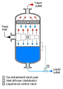
Wellhead gas from the individual fields was routed to either the Suction, the Interstage or the Discharge Manifold on Murdoch MC depending on its pressure. [7]  Gas from the Suction Manifold was routed to the Suction Slug Catcher where liquids were removed. Gas flowed successively to the LP Suction Scrubber, the First Stage Gas Compressor and the Intercooler. Here it was comingled with gas from the Interstage Manifold which had flowed through the Interstage Slug Catcher. The combined flow was routed to the Interstage Scrubber, the Second Stage Gas Compressor and the Export Gas Cooler. Gas was returned to the MD platform and to the Theddlethorpe trunk line. Recovered liquids were injected into the trunk line. [7]

To increase the compression capacity a compressor module was added to the Murdoch MC platform in 2003. [8]

Telecommunications

Murdoch MD was connected to the Tampnet (formerly NorSea Com-1) submarine telecommunications cable system. [9] It has landing points at Lowestoft, Suffolk, UK and Kårstø, Rogaland, Norway. It is connected to:

1.      Draupner platform, operated by Gassco

2.      Ula oil field, operated by BP

3.      Ekofisk, operated by ConocoPhillips

4.      Valhall oil field, operated by BP

5.      Murdoch gas field, operated by ConocoPhillips (now disconnected) [9]

Decommissioning

Some CMS fields were shut-in in the 2010s when they became uneconomic to operate. Production from the CMS ceased with the shutdown of the Theddlethorpe gas terminal in August 2018. The platforms and subsea wellhead structures are being removed. [6]

See also

Related Research Articles

The Clair oilfield is an offshore oil field in Scottish territorial waters 75 kilometres (47 mi) west of Shetland in water depths of up to 140 metres (460 ft). The field is the largest oilfield on the UK Continental Shelf with an estimated 8 billion barrels of oil-in-place, according to the BP Plc’s website. It extends over an area of some 220 square kilometres (85 sq mi), covering five licence blocks.

The Everest gasfield is located in the Central North Sea, 233 kilometres (145 mi) east of Aberdeen, Scotland. It lies in the United Kingdom Continental Shelf blocks 22/9, 22/10a and 22/14a. The gasfield was discovered by Amoco in 1982 with first gas produced in 1993.

<span class="mw-page-title-main">Schiehallion oilfield</span>

The Schiehallion oilfield is a deepwater offshore oilfield approximately 175 kilometres (110 mi) west of the Shetland Islands in the North Atlantic Ocean. The Schiehallion and adjacent Loyal field were jointly developed by BP on behalf of the Schiehallion field partners; BP, Shell, Amerada Hess, Murphy Oil, Statoil and OMV, and the Loyal field partners; BP and Shell.

An oil production plant is a facility which processes production fluids from oil wells in order to separate out key components and prepare them for export. Typical oil well production fluids are a mixture of oil, gas and produced water. An oil production plant is distinct from an oil depot, which does not have processing facilities.

The Eastern Trough Area Project, commonly known as ETAP, is a network of nine smaller oil and gas fields in the Central North Sea covering an area up to 35 km in diameter. There are a total of nine different fields, six operated by BP and another three operated by Shell, and together, they are a rich mix of geology, chemistry, technology and equity arrangements.

"Offshore", when used in relation to hydrocarbons, refers to operations undertaken at, or under the, sea in association with an oil, natural gas or condensate field that is under the seabed, or to activities carried out in relation to such a field. Offshore is part of the upstream sector of the oil and gas industry.

<span class="mw-page-title-main">Vapor–liquid separator</span> Device for separating a liquid-vapor mixture into its component phases

In chemical engineering, a vapor–liquid separator is a device used to separate a vapor–liquid mixture into its constituent phases. It can be a vertical or horizontal vessel, and can act as a 2-phase or 3-phase separator.

<span class="mw-page-title-main">Douglas Complex</span>

The Douglas Complex is a 54-metre (177 ft) high system of three linked platforms in the Irish Sea, 24 kilometres (15 mi) off the North Wales coast. The Douglas oil field was discovered in 1990, and production commenced in 1996. Now operated by Eni, the complex consists of the wellhead platform, which drills into the seabed, a processing platform, which separates oil, gas and water, and thirdly an accommodation platform, which is composed of living quarters for the crew. This accommodation module was formerly the Morecambe Flame jack-up drilling rig.

NorSea Com-1, now called Tampnet, is a submarine telecommunications cable system in the North Sea linking the UK and Norway, and connecting five off-shore platforms.

<span class="mw-page-title-main">Theddlethorpe Gas Terminal</span> Gas terminal in Theddlethorpe St Helen

Theddlethorpe Gas Terminal (TGT) is a former gas terminal on the Lincolnshire coast on Mablethorpe Road at Theddlethorpe St Helen close to Mablethorpe in East Lindsey in England. It is just off the A1031 and next door to a holiday camp and Mablethorpe Seal Sanctuary and Wildlife Centre.

<span class="mw-page-title-main">Bacton Gas Terminal</span> Gas terminal in Bacton

The Bacton Gas Terminal is a complex of six gas terminals within four sites located on the North Sea coast of North Norfolk in the United Kingdom. The sites are near Paston and between Bacton and Mundesley; the nearest town is North Walsham.

<span class="mw-page-title-main">Cameron International</span> American oilfield services company

Cameron International Corporation (formerly Cooper Cameron Corporation (CCC) and Cooper Oil Tool, Cameron Iron Works) though now operating under Schlumberger, is a global provider of pressure control, production, processing, and flow control systems as well as project management and aftermarket services for the oil and gas and process industries. Cameron was acquired by Schlumberger (SLB) in 2016, and now operates as 'Cameron, a Schlumberger Company.' At the start of the SLB acquisition in 2015, Cameron employed approximately 23,000 people and delivered $9.8 billion in revenue.

<span class="mw-page-title-main">Buzzard oil field</span>

The Buzzard Oil Field is an oil field located in the North Sea Blocks 19/10, 19/5a, 20/6 and 20/1s. It was discovered in 2001 by PanCanadian, and developed initially by PanCanadian's successor EnCana and then by Nexen. The oil field was initially operated and owned by Nexen which is now a subsidiary of China's CNOOC.

The Anglia gas field, is a natural gas field in the United Kingdom's continental shelf of the Southern North Sea. It is located in blocks 48/18 and 48/19 about 60 km (37 mi) east of the Lincolnshire coast. The reservoir is located at a depth of approximately 8,500 feet (2,600 m) subsea. The field was discovered in February 1972. Detailed seismic and appraisal well work were conducted in 1984. The reservoir was estimated to have 235 billion cubic feet of gas in place.

The Viking gas field is a group of natural gas and associated condensate fields located under the southern North Sea about 85 miles from the Lincolnshire coast. The field was in production from 1972 to 2018.

The K13 gas fields were major natural gas producing fields in the Netherlands sector of the North Sea, about 130 km west of Den Helder. The fields started producing gas in 1975 but are no longer operational except for one installation used as a riser platform.

The Lincolnshire Offshore Gas Gathering System (LOGGS) was a major natural gas collection, processing and transportation complex in the UK sector of the southern North Sea. It comprised five bridge-linked platforms about 118 km east of the Lincolnshire coast, which operated from 1988 to 2018. 

The Pickerill and Juliet gas fields are decommissioned natural gas producing facilities in the UK sector of the southern North Sea. The fields are located about 66 km (41 mi) east of Spurn Head, Lincolnshire. Pickerill was in operation from 1992 until 2018 and Juliet from 2014 to 2018.

The Clipper gas field is a major natural gas reservoir and gas production facility in the UK sector of the southern North Sea. The field is located about 73 km north-north-east of Bacton, Norfolk; the Clipper production facility has operated since 1990.

The A-Fields are natural gas reservoirs and gas production facilities in the southern North Sea; about 123 km east of Spurn Head, Yorkshire. The fields produced natural gas from 1988 to 2016.

References

  1. 1 2 3 4 Department of Trade and Industry (2004). The Energy Report. London: HMSO. pp. 35, 75, 121, 125, Map 10. ISBN   0115153802.
  2. 1 2 3 "Inventory of Offshore Installations". OSPAR. Archived from the original on 2021-11-25. Retrieved 27 November 2021.
  3. 1 2 3 "Oil and Gas UK – Field data". Oil & Gas UK. Archived from the original on 2015-10-27. Retrieved 27 November 2021.
  4. "Caister Murdoch gas fields". abarrelfull. Archived from the original on 2014-06-26. Retrieved 27 November 2021.
  5. Conoco Gas Operations schematic Map (c. 2000)
  6. 1 2 "Caister Decommissioning Programmes" (PDF). Archived (PDF) from the original on 2021-05-05. Retrieved 27 November 2021.
  7. 1 2 Murdoch Compression Flow scheme (undated)
  8. "Caister Murdoch Phase 3". Archived from the original on 2003-02-19. Retrieved 24 November 2021.
  9. 1 2 "Tampnet".