In 1924, the Hall was bought by the Church of England Temperance Society, for use as a retreat. In the 1950s, it was the home of St Chad's School but suffered financial problems and a severe fire in 1955. In 2005 it was restored and converted to private flats.[6]
Gallery
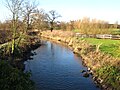
River Anker
Caldecote Hall
Sources
Sheasby, Alan (1990) Skylark Fields: A Forties Childhood Exeter, Devon: Wheaton Publishers Ltd/Warwickshire Books, ISBN1-871942-04-7 (Includes a map of Caldecote and surrounding district)
This page is based on this Wikipedia article Text is available under the CC BY-SA 4.0 license; additional terms may apply. Images, videos and audio are available under their respective licenses.