Related Research Articles

Dodge City Regional Airport is three miles east of Dodge City, in Ford County, Kansas. It is used for general aviation and is subsidized by the Essential Air Service program.
Great Bend Municipal Airport is five miles west of Great Bend, in Barton County, Kansas. It is used for general aviation and formerly saw one airline, subsidized by the Essential Air Service program.

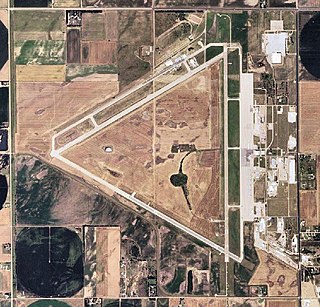
Herington Regional Airport is a public use airport in Morris County, Kansas, United States. The airport is owned by the City of Herington and is located seven nautical miles northeast of its central business district. Although the airport is in Morris County, most of Herington is located in Dickinson County. Previously known as Herington Municipal Airport, the airport is located on the site of the former Herington Army Airfield. This airport is included in the National Plan of Integrated Airport Systems for 2011–2015, which categorized it as a general aviation facility.
San Marcos Regional Airport is a public use airport located in Caldwell County, Texas, United States. It is four nautical miles (7 km) east of the central business district of San Marcos, a city that is mostly in Hays County. The airport is owned by the City of San Marcos and operated by Texas Aviation Partners. It is located east of the border of Caldwell County and Hays County. Before it was operated as a civilian airport it was known as Gary Air Force Base.

Abbeville Municipal Airport is a city-owned, public-use airport located three nautical miles north of the central business district of Abbeville, a city in Henry County, Alabama, United States. It is the only airport that serves the city of Abbeville.

Wetumpka Municipal Airport is a city-owned, public-use airport located six nautical miles west of the central business district of Wetumpka, a city in Elmore County, Alabama, United States. It is included in the FAA's National Plan of Integrated Airport Systems for 2011–2015, which categorized it as a general aviation facility. During World War II the airport, known then as Elmore Auxiliary Field, served as an auxiliary field for Gunter Army Airfield training operations. In 2013 the airport was listed in the Alabama Register of Landmarks and Heritage.

Camden Municipal Airport is a city-owned, public-use airport located three nautical miles (6 km) southwest of the central business district of Camden, a city in Wilcox County, Alabama, United States.

Grove Hill Municipal Airport was a city-owned public-use airport located two nautical miles southeast of the central business district of Grove Hill, a city in Clarke County, Alabama, United States. According to the FAA's National Plan of Integrated Airport Systems for 2009–2013, it was categorized as a general aviation facility. The airport has been permanently closed.

Headland Municipal Airport is a city-owned, public-use airport located two nautical miles northeast of the central business district of Headland, a city in Henry County, Alabama, United States.
Caldwell Municipal Airport is a city-owned, public-use airport located 1 nautical mile (2 km) southwest of the central business district of Caldwell, a city in Burleson County, Texas, United States.
Butte Municipal Airport is a public-use airport located in Butte, Alaska. It is five nautical miles (9 km) southeast of the central business district of Palmer, a city in the Matanuska-Susitna Borough of the U.S. state of Alaska. The airport is privately owned by the Butte Airman's Association.

Bentonville Municipal Airport is a city-owned, public-use airport located two nautical miles (3.7 km) south of the central business district of Bentonville, a city in Benton County, Arkansas, United States. It is also known as Louise M. Thaden Field or Louise Thaden Field, a name it was given in 1951 to honor Louise McPhetridge Thaden (1905–1979), an aviation pioneer from Bentonville.
Jetmore Municipal Airport is a city-owned, public-use airport seven miles south of Jetmore, a city in Hodgeman County, Kansas, United States.
Stockton Municipal Airport is a city-owned, public-use airport located three nautical miles (6 km) southwest of the central business district of Stockton, a city in Rooks County, Kansas, United States.
Eureka Municipal Airport, also known as Lt. William M. Milliken Airport, is a city-owned, public-use airport located two nautical miles (4 km) north of the central business district of Eureka, a city in Greenwood County, Kansas, United States. It is included in the National Plan of Integrated Airport Systems for 2011–2015, which categorized it as a general aviation facility.
Stanton County Municipal Airport is a county-owned, public-use airport in Stanton County, Kansas, United States. It is located two nautical miles (4 km) northeast of the central business district of Johnson, Kansas, which is also known as Johnson City. This airport was included in the National Plan of Integrated Airport Systems for 2011–2015, which categorized it as a general aviation facility.
Sublette Municipal Airport is a city-owned, public-use airport located one nautical mile (2 km) northeast of the central business district of Sublette, a city in Haskell County, Kansas, United States. It was formerly known as Sublette Flying Club Airport.
Marion Municipal Airport is a city-owned, public-use airport located two nautical miles (4 km) southeast of the central business district of Marion, a city in Marion County, Kansas, United States.
Denison Municipal Airport is a city-owned, public-use airport located two nautical miles (4 km) southwest of the central business district of Denison, a city in Crawford County, Iowa, United States. It is included in the National Plan of Integrated Airport Systems for 2011–2015, which categorized it as a general aviation facility.
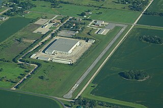
Osage City Municipal Airport is a city-owned public-use airport located one nautical mile east of the central business district of Osage City, a city in Osage County, Kansas, United States.
References
- 1 2 3 FAA Airport Form 5010 for 01K PDF . Federal Aviation Administration. Effective 30 June 2011.