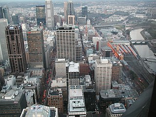
Hoddle Grid is the contemporary name given to the approximately 1-by-0.5-mile grid of streets that form the Melbourne central business district, Australia. Bounded by Flinders Street, Spring Street, La Trobe Street, and Spencer Street, it lies at an angle to the rest of the Melbourne suburban grid, and so is easily recognisable. It is named after the surveyor Robert Hoddle, who marked it out in 1837, establishing the first formal town plan. This grid of streets, laid out when there were only a few hundred settlers, became the nucleus for what is now Melbourne, a city of over five million people.

Queen Victoria Village, generally known as QV Melbourne or just QV, is a precinct in the Melbourne central business district, Victoria, Australia. Covering the city block bounded by Lonsdale, Little Lonsdale, Swanston, and Russell Streets, and located directly opposite the State Library of Victoria and Melbourne Central, QV comprises a large shopping centre, a central plaza, an underground food court, Melbourne central city's first full-size supermarket and apartment buildings.

The Melbourne Sports and Entertainment Precinct is a series of sports stadiums and venues, located in Melbourne, Victoria, in Australia. The precinct is situated around 3 km east of the Melbourne central business district, located in suburbs of Melbourne and Jolimont, near East Melbourne and Richmond.

La Trobe Street is a major street and thoroughfare in the Melbourne central business district, Victoria, Australia. It runs roughly east–west and forms the northern boundary of the central business district. The street was laid out as an extension of the original Hoddle Grid in 1839 and was named after Charles La Trobe. La Trobe Street extends from Victoria Street in the east to Harbour Esplanade in the west.

Hardware Lane is a wide laneway in the Melbourne central business district, Australia. It runs roughly north–south between Bourke Street and Little Lonsdale Street. It changes name to Hardware Street between Lonsdale and Little Lonsdale Streets.

The City Square was a public plaza located in the Central Business District (CBD) of Melbourne, Victoria, Australia. The site was bounded by Swanston Street, Collins Street, Flinders Lane and the Westin Hotel. The historic landmarks of Melbourne Town Hall and St Paul’s Cathedral were across the streets to the north and south respectively.

Lonsdale Street is a main street and thoroughfare in the Melbourne central business district, Australia. It runs roughly east–west and was laid out in 1837 as one of Melbourne's original boundaries within the Hoddle Grid. The street extends from Spring Street in the east to Spencer Street in the west.

William Street is a major street in the Melbourne central business district, Victoria, Australia. It runs roughly north–south from Flinders Street to Victoria Street, and was laid out in 1837 as part of the original Hoddle Grid. The street is located in-between King Street and Queen Street.

Melbourne Central is a large shopping centre, office, and public transport hub in the city of Melbourne, Victoria, Australia. It was designed by Japanese architect Kisho Kurokawa, and opened in 1991.
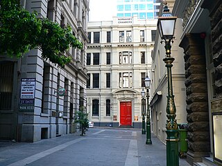
Bank Place is a street in the Melbourne central business district, Australia. It is a laneway running roughly north-south between Collins Street and Little Collins Street.

Howey Place, formerly known as "Cole's Walk" is a shopping arcade in Melbourne, Victoria. It is a short, narrow covered laneway, running south from Little Collins Street between Swanston Street and Elizabeth Street in the central business district of Melbourne.

McKillop Street is a street in Melbourne, Victoria, Australia]]. It is a short, quiet and narrow open laneway, running between Bourke Street and Little Collins Street between Queen Street and Elizabeth Street in the Melbourne central business district.
Block Place is a street in Melbourne. It is a short, narrow partially covered laneway, running south from Little Collins Street between Swanston Street and Elizabeth streets in the Melbourne central business district.
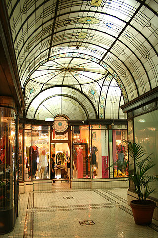
Cathedral Arcade is a heritage shopping arcade in Melbourne, Victoria, Australia.
The St. Jerome's Laneway Festival, commonly referred to as Laneway, began in Caledonian Lane, Melbourne, Australia, on Sunday, February 27, 2005. Beginning as predominantly an indie music event, the festival grew in popularity and expanded to five Australian cities—Melbourne, Sydney, Brisbane, Adelaide and Fremantle—as well as Auckland, New Zealand and Singapore.
The Greek Precinct, Melbourne in Victoria, Australia, is a Greek cultural area centred on the eastern end of Lonsdale Street in the Melbourne city centre. The area runs adjacent to Melbourne Chinatown on Little Bourke Street.

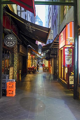
The Melbourne central business district in Australia is home to numerous lanes and arcades. Often called "laneways", these narrow streets and pedestrian paths date mostly from the Victorian era, and are a popular cultural attraction for their cafes, bars and street art.

Little Lon was the popular name for a slum and red-light district in Melbourne, Australia.

380 Melbourne is a residential and hotel skyscraper in Melbourne, Victoria, Australia.

St. Collins Lane is a shopping centre completed in 2016, designed by ARM Architecture, which stretches between Collins and Little Collins streets in Melbourne, Australia. Previously there were restaurants, arcades and hotels on the site.
