Los Alerces National Park is located in the Andes in Chubut Province in the Patagonian region of Argentina. Its western boundary coincides with the Chilean border. Successive glaciations have molded the landscape in the region creating spectacular features such as moraines, glacial cirques and clear-water lakes. The vegetation is dominated by dense temperate forests, which give way to alpine meadows higher up under the rocky Andean peaks. A highly distinctive and emblematic feature is its alerce forest; the globally threatened alerce tree is the second longest living tree species in the world. The alerce forests in the park are in an excellent state of conservation. The property is vital for the protection of some of the last portions of continuous Patagonian Forest in an almost pristine state and is the habitat for a number of endemic and threatened species of flora and fauna.

The Northern Patagonian Ice Field, located in southern Chile, is the smaller of two remnant parts in which the Patagonian Ice Sheet in the Andes Mountains of southern South America can be divided. It is completely contained within the boundaries of Laguna San Rafael National Park.

Laguna San Rafael National Park is a park located on the Pacific coast of southern Chile. The park is named for the San Rafael Lagoon formed by the retreat of the San Rafael Glacier. Created in 1959, it covers an area of 17,420 km2 (6,726 sq mi) and includes the Northern Patagonian Ice Field. A fjord more than 16 km (10 mi) long is one of the park's principal attractions.

The Southern Patagonian Ice Field, located at the Southern Patagonic Andes between Chile and Argentina, is the world's second largest contiguous extrapolar ice field. It is the bigger of two remnant parts of the Patagonian Ice Sheet, which covered all of southern Chile during the last glacial period, locally called the Llanquihue glaciation.

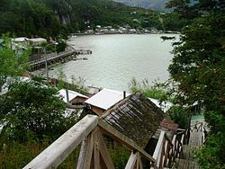
Quellón is a Chilean port city and commune in Chiloé Province, in southern Chiloé Island, Los Lagos Region. It is one of the southern end-stations of the Panamerican Highway and the Pacific Coast Highway. The city is a hub for aquaculture and fisheries in southern Chiloé and the Guaitecas and Chonos archipelagoes to the south. Various ferry lanes connects Quellón with the Patagonian settlements such as Melinka, Puerto Cisnes and Puerto Chacabuco.

The Carretera Austral is the name given to Chile's Route 7. The highway runs south for about 1,240 kilometers (770 mi) from Puerto Montt to Villa O'Higgins, passing through rural Patagonia.

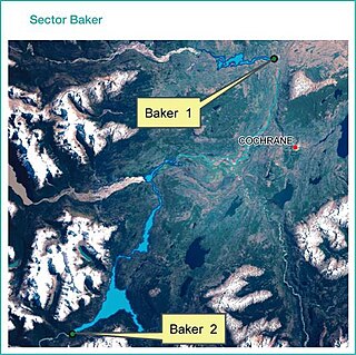
Cochrane is a Chilean town and commune in Capitán Prat Province of the Aisén Region. According to the 2002 census it has a population of 2,867. The urban population in 2002 was 2,217 and the rural population was 650.

Bernardo O'Higgins National Park is the largest of the protected areas in Chile, covering an area of 3,525,901 ha, in both the Aysén and Magallanes and Antártica Chilena regions. Management of this and other national parks in Chile is entrusted to the Corporación Nacional Forestal (CONAF). The park is named after General Bernardo O'Higgins, the first head of state of the Republic of Chile. Los Glaciares National Park (Argentina) and Torres del Paine National Park are its neighbours to the east, Laguna San Rafael National Park is located to the north, the Alacalufes National Reserve to the southwest, and the Katalalixar National Reserve to the northwest.
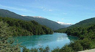
The Baker River is a river located in the Aysén del General Carlos Ibáñez del Campo Region of the Chilean Patagonia. It is Chile's largest river in terms of volume of water. The river flows out of Bertrand Lake, which is fed by General Carrera Lake. It runs along the east side of the Northern Patagonian Ice Field and empties into the Pacific Ocean, near the town of Caleta Tortel. The river forms a delta, dividing into two major arms, of which only the northernmost one is navigable.

Cerro Arenales is a heavily ice-covered stratovolcano located in the Aysén del General Carlos Ibáñez del Campo Region of Chile, within Laguna San Rafael National Park. It towers over the southern part of the Northern Patagonian Ice Field. Arenales has a summit elevation of 3,437 meters above sea level.

Baker Channel, also known as Calen Inlet, is a channel of Chile located in the Tortel, Aysén del General Carlos Ibáñez del Campo Region. The Baker River discharges into Martinez Inlet, the northern part of this large estuary. It penetrates the mainland about 75 miles (121 km) and opens into Tarn Bay at the south-east corner of the Gulf of Penas. Merino Jarpa Island lies wholly within this great estuary, while at its mouth lies a group of smaller islands, called Baker Islands, which separate it from Messier Channel. Baker Channel also receives the waters of the O'Higgins/San Martín Lake through the Pascua River. The lake's far-reaching fjord-like arms extend approximately from lat. 49° 11' to 48° 22' S. Its north-west arm is that which drains into the mentioned river.

Jorge Montt Glacier is a tidewater glacier located in the Aisén Region of Chile, south of the town of Caleta Tortel. It lies at the north end of the Southern Patagonian Ice Field, within Bernardo O'Higgins National Park. The mouth of Pascua River is located in the vicinity of the glacier calving front.

Tortel is a Chilean commune located at the outflow of the Baker River and Pascua River to the Pacific Ocean. It lies between the Northern and Southern Patagonian Ice Field in the Capitán Prat Province in the Aysén Region. The commune is administered by the municipality in Caleta Tortel, the principal settlement.
HidroAysén was a controversial megaproject that aimed to build five hydroelectric power plants in Chile's Aysén Region, two on the Baker River and three on the Pascua River. Planned for construction during the 2010s, the project was definitely cancelled by its contractors in November 2017.

Yendegaia Bay is a bay in the Beagle Channel, in the southern coast of the Chilean part of Isla Grande de Tierra del Fuego. The bay is at the mouth of Yendegaia River and the only settlement on its shores is Caleta Ferrari.
The southern coast of Chile presents a large number of fjords and fjord-like channels from the latitudes of Cape Horn to Reloncaví Estuary. Some fjords and channels are important navigable channels providing access to ports like Punta Arenas, Puerto Chacabuco and Puerto Natales.

Mitchell Fjord is a 30- to 50-km long fjord in Aysén Region, Chile, stretching southeast from the vicinities of Baker Channel into the valley of Bravo River. Through a ferry based on Puerto Yungay, the channel provides access to the southernmost portion of Carretera Austral and constitutes thus the only discontinuous section of Carretera Austral south of Chaitén.
Río Bravo Airport is an airstrip 36 kilometres (22 mi) southeast of Caleta Tortel in the Aysén Region of Chile. The airstrip serves settlements along the Estero Mitchell, one of the many channels leading to the Pacific Ocean.
Río Pascua Airport, is an airport serving small settlements along the Pascua River in the Aysén Region of Chile. The runway is 51 kilometres (32 mi) south-southwest of Caleta Tortel, a coastal village.

Marcos José Couch, Argentinean mountain climber, known for his professional achievements in mountains such as the Shishapangma in Tibet, or the Fitz Roy in Patagonia. Since 1987 he is a mountain guide and has been working internationally.