
St Ives is a medieval market town and civil parish in the Huntingdonshire district in Cambridgeshire, England, 5 miles (8 km) east of Huntingdon and 12 miles (19 km) north-west of Cambridge. St Ives is historically in the county of Huntingdonshire.
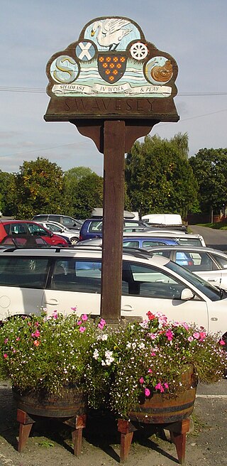
Swavesey is a village lying on the Prime Meridian in Cambridgeshire, England, with a population of 2,463. The village is situated 9 miles to the north west of Cambridge and 3 miles south east of St Ives.
The Wisbech and March line is a railway line between March and Wisbech in Cambridgeshire, England. A number of proposals are currently being investigated relating to the possible restoration of passenger services along the route.

Cambridge railway station is the principal station serving the city of Cambridge in the east of England. It stands at the end of Station Road, 1 mile (1.6 km) south-east of the city centre. It is the northern terminus of the West Anglia Main Line, 55 miles 52 chains (89.6 km) down the line from London Liverpool Street, the southern terminus.

Cottenham is a village in Cambridgeshire, England. Cottenham is one of the larger villages surrounding the city of Cambridge, located around five miles north of the city. The population of the civil parish at the 2011 Census was 6,095. Cottenham is one of a number of villages that make up the historical Fen Edge region in between Cambridge and Ely, which were originally settlements on the shore of the marshes close to the city of Cambridge, then an inland port.

The Ipswich–Ely line is a railway line linking East Anglia to the English Midlands via Ely. There is also a branch line to Cambridge. Passenger services are operated by Greater Anglia. It is a part of Network Rail Strategic Route 5, SRS 05.07, 05.08 and part of SRS 07.03. The line has previously been part of the Great Eastern Main Line.
Histon is a village and civil parish in the South Cambridgeshire district, in the county of Cambridgeshire, England. It is immediately north of Cambridge – and is separated from the city – by the A14 road which runs east–west. In 2011, the parish had a population of 4,655. Histon forms part of the Cambridge built-up area.

March railway station is a stop on the Ely–Peterborough line in the east of England and serves the market town of March, Cambridgeshire, England. It is 85 miles 76 chains (138.3 km) measured from London Liverpool Street via Ely and is situated between Manea and Whittlesea stations.

The Cambridgeshire Guided Busway is a guided busway that connects Cambridge, Huntingdon and St Ives in Cambridgeshire, England. It is the longest guided busway in the world, surpassing the O-Bahn Busway in Adelaide, South Australia.

Longstanton is a village and civil parish in South Cambridgeshire, England, 6 miles (9.7 km) north-west of Cambridge city centre. Longstanton occupies 2,775 acres (1,123 ha). Longstanton was created in 1953 from the two parishes of Long Stanton All Saints and Long Stanton St Michael. While the village is called Longstanton, the alternative form Long Stanton is still in use, for example when referring to the separate pre-1953 parishes, or to the current ecclesiastical parish.
National Cycle Route 51 is an English long distance cycle route running broadly east-west connecting Colchester and the port of Harwich to Oxford via Ipswich, Bury St Edmunds, Cambridge, Bedford, Milton Keynes, Bicester, and Kidlington. It runs for 189.3 miles for the full route.
The Great Northern and Great Eastern Joint Railway, colloquially referred to as "the Joint Line" was a railway line connecting Doncaster and Lincoln with March and Huntingdon in the eastern counties of England. It was owned jointly by the Great Northern Railway (GNR) and the Great Eastern Railway (GER). It was formed by transferring certain route sections from the parent companies, and by the construction of a new route between Spalding and Lincoln, and a number of short spurs and connections. It was controlled by a Joint Committee, and the owning companies operated their own trains with their own rolling stock. The Joint Line amounted to nearly 123 miles (198 km) of route.
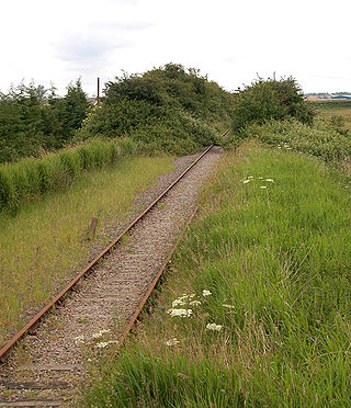
Oakington railway station was a station in Oakington, Cambridgeshire, on the line between Cambridge and St Ives. It opened in 17 August 1847 and was closed during the Beeching Axe in 5 October 1970. The station building remains as a private house but the track has been replaced by the Cambridgeshire Guided Busway.

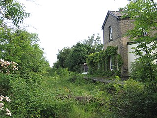
Histonrailway station is a disused railway station in Impington, Cambridgeshire on the Cambridge–St Ives branch of the Great Eastern Railway. The station was closed as part of the Beeching Axe in 1970; but the line through the station remained open for freight trains until the early 1992. The station site was partially demolished, with the platforms and a small building on the down side being removed and the canopy severely truncated during the construction of the Cambridgeshire Guided Busway but the station building was saved from being demolished; a car park was planned to be built on the site of the demolished station building. The building has operated as a cafe since 2021.
St Ives railway station is a former railway station in St Ives, Cambridgeshire. It formed a junction, with lines to the east heading towards Cambridge, north towards Ely and March and west towards Godmanchester. It opened on 19 August 1847, closed on 5 October 1970, and was demolished in 1977. The site is now occupied by the St. Ives "Park and Ride" area.
Orchard Park, previously known as Premier Park and before that Arbury Park, is a district and civil parish of South Cambridgeshire, England, contiguous with the city of Cambridge. Previously agricultural land and the site of Premier Park a huge estate for Premier Travel who amongst other things was a main National Express operator with housing for its drivers. the area is currently an extensive housing estate with additional development continuing on adjacent land.

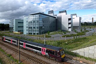
Cambridge North railway station is a railway station located in northern Cambridge, immediately adjacent to the suburb of Chesterton, close to Cambridge Science Park. The station is on the Fen Line, which runs from Cambridge to King's Lynn. It connects to the Cambridgeshire Guided Busway, and provides an interchange with Park & Ride and local bus services.
Cambridge is a university town and the administrative centre of the county of Cambridgeshire, England. It lies in East Anglia about 50 miles (80 km) north of London. Its main transport links are the M11 road to London, the A14 east–west road and the West Anglia Main Line railway to London.

Chesterton railway station was located on the line between Cambridge and Histon. It opened in 1850 and closed the same year.