Margate is a small seaside town on the Channel Highway between North-West Bay and the Snug Tiers, 7 kilometres (4 mi) south of Kingston in Tasmania, Australia. It is mostly in the Kingborough Council area, with about 4% in the Huon Valley Council LGA. Margate is also part of the Greater Hobart statistical area.

Clarence City Council is a local government body in Tasmania, and one of the five municipalities that constitutes the Greater Hobart Area. The Clarence local government area has a population of 61,531, covering the eastern shore of the Derwent River from Otago to the South Arm Peninsula and the smaller localities of Cambridge, Richmond, and Seven Mile Beach.
Brighton is a suburb 27 km north of Hobart, in Tasmania, Australia. It is between Pontville and the outer Hobart suburb of Bridgewater on the Midland Highway. At the 2021 census, Brighton had a population of 4,983.
Richmond is a town in Tasmania about 25 km north-east of Hobart, in the Coal River region, between the Midland Highway and Tasman Highway. At the 2006 census, Richmond had a population of 880.

Southern Midlands is a local government body in Tasmania, covering the southern region of the Tasmanian central midlands. Southern Midlands is classified as a rural local government area and has a population of 6,118, the major localities of the region include Campania, Kempton, Mangalore and the principal town of Oatlands.

Bicheno is a locality and town on the east coast of Tasmania, Australia, 185 km north-east of Hobart on the Tasman Highway, with a population of around 950. It is part of the municipality of Glamorgan-Spring Bay. The town is primarily a fishing port and a beach resort.

HuonvilleHYOO-on-vil is a town located on the banks of the Huon River in the Huon Valley, in the south-east of Tasmania, Australia. It serves as the administrative centre of the Huon Valley Council and is the largest town in the Huon Valley region. Situated approximately 38 kilometres south of the state capital, Hobart, Huonville acts as a gateway to Tasmania’s wilderness areas and the Southwest National Park.

Bagdad is a small town 37 kilometres (23 mi) north of Hobart, Tasmania. It is in the Southern Midlands Council.
Cressy is a small town 35 kilometres (22 mi) south-west of Launceston, Tasmania. It came into existence in the 1850s to service the surrounding wheat farms. At the 2006 census, Cressy had a population of 670. It is known as Tasmania's "Trout capital" for the good fishing in the area. It is also home to an extensive agriculture research facility for the Tasmanian Institute of Agricultural Research.

Bracknell is a rural locality and town in the local government areas of Meander Valley and Northern Midlands in the Launceston and Central regions of Tasmania. The locality is about 22 kilometres (14 mi) south-east of the town of Westbury. The 2016 census has a population of 459 for the state suburb of Bracknell.
Rossarden is a rural locality in the local government areas (LGA) of Northern Midlands (89%) and Break O'Day (11%) in the Central and North-east LGA regions of Tasmania. The locality is about 81 kilometres (50 mi) east of the town of Longford. The 2016 census recorded a population of 42 for the state suburb of Rossarden.
Middlemount is a rural town and locality in the Isaac Region, Queensland, Australia. In the 2021 census, the locality of Middlemount had a population of 1,899 people.

Valley View is a suburb of Adelaide, South Australia. It spans three separate local government areas. They are the City of Salisbury, the City of Port Adelaide Enfield, and the City of Tea Tree Gully. The suburb's boundaries are defined by the intersection of Walkleys, Grand Junction and North East Roads in the south, and Wright and Kelly Roads in the north and east.

The City of Albury is a local government area in the Riverina region of New South Wales, Australia. The area covers 305.9 square kilometres (118.1 sq mi) to the north of the Murray River. The area extends around 10 to 12 kilometres east and west along the river from the centre of Albury and up to 20 kilometres (12 mi) north. The population of the City of Albury area was 53,767 in June 2018.
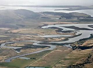
The Coal River Valley is located in southern Tasmania, primarily within the City of Clarence, and is known for its fertile agricultural land and rich history. The valley lies to the east of Hobart, nestled between the Meehan Range and the Pontos Range, with the historic town of Richmond at its heart. Other key townships in the valley include Colebrook, Campania, and Cambridge.
Brighton Council is a local government body in Tasmania, situated in the south-east of the state, north of Hobart. The Brighton local government area is classified as urban and has a population of 18,995, it is based in the town of Brighton but also covers the far northern Hobart suburbs of Bridgewater, Gagebrook, Honeywood and Old Beach.
Jericho is a rural locality in the local government area (LGA) of Southern Midlands in the Central LGA region of Tasmania. The locality is about 14 kilometres (8.7 mi) south-west of the town of Oatlands. The 2016 census recorded a population of 59 for the state suburb of Jericho.
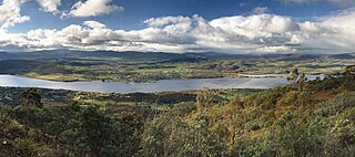
In the Australian state of Tasmania, there are many areas which are commonly known by regional names. Regions are areas that share similar characteristics. These characteristics may be natural such as the Furneaux Islands, the coastline, or the Central Highlands. Alternatively, the characteristics may be cultural, such as a viticulture land use. Tasmania is divided by numerous regional boundaries, based on different characteristics. In many cases boundaries defined by different government agencies are coterminous and are often cited by the Australian and local media that tend to distinguish between North West, West Coast, Southern, and East Coast.

Conara is a rural locality in the local government area (LGA) of Northern Midlands in the Central LGA region of Tasmania. The locality is about 50 kilometres (31 mi) south-east of the town of Longford. The 2016 census recorded a population of 130 for the state suburb of Conara.
Colebrook is a rural locality and town in the local government area of Southern Midlands in the Central region of Tasmania. It is located about 29 kilometres (18 mi) south of the town of Oatlands. The 2021 census gave a population of 372 for Colebrook.
