Campanillas

Last updated
Campanillas
District of Málaga
Campanillas.svg
Country Flag of Spain.svg Spain
Aut. community Flag of Andalusia.svg Andalusia
Municipality Flag of Malaga, Spain.svg Málaga
Area
  Total 59.77 km2 (23.08 sq mi)
Population 17,472
  Density 292.32/km2 (757.1/sq mi)
Málaga district number 9
Address of council Calle Ramírez Arcas 2, 29590

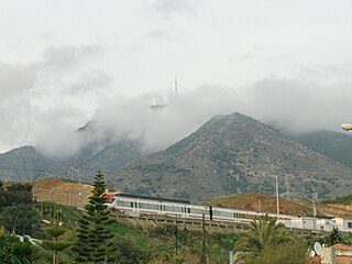
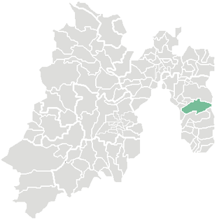
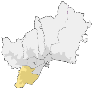
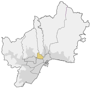
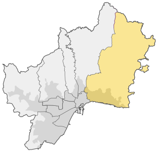
Campanillas, also known as District 9, is one of the 11 districts of the city of Málaga, Spain.

Málaga Municipality in Andalusia, Spain

Málaga is a municipality, capital of the Province of Málaga, in the Autonomous Community of Andalusia, Spain. With a population of 571,026 in 2018, it is the second-most populous city of Andalusia and the sixth-largest in Spain. The southernmost large city in Europe, it lies on the Costa del Sol of the Mediterranean, about 100 kilometres east of the Strait of Gibraltar and about 130 km (80.78 mi) north of Africa.

Spain Kingdom in Southwest Europe

Spain, officially the Kingdom of Spain(Spanish: Reino de España), is a country mostly located on the Iberian Peninsula in Europe. Its territory also includes two archipelagoes: the Canary Islands off the coast of Africa, and the Balearic Islands in the Mediterranean Sea. The African enclaves of Ceuta and Melilla make Spain the only European country to have a physical border with an African country (Morocco). Several small islands in the Alboran Sea are also part of Spanish territory. The country's mainland is bordered to the south and east by the Mediterranean Sea except for a small land boundary with Gibraltar; to the north and northeast by France, Andorra, and the Bay of Biscay; and to the west and northwest by Portugal and the Atlantic Ocean.

It comprises the wards (barrios) of Amoníaco, Campanillas, Castañetas, Centro de Transporte de Mercancías, Colmenarejo, El Brillante, El Prado, El Tarajal, Estación de Campanillas, Parque Industrial Trévenez, Huertecilla Mañas, Industrial Intelhorce, Industrial Pilar del Prado, La Estación, La Fábrica, Las Manseras, Loma del Campo, Los Asperones 2, Los Chopos, Maqueda, Mercamálaga, Miranda, Oliveros, Parque Cementerio, Parque Tecnológico, Pilar del Prado, Polígono Industrial La Huertecilla, Roquero, Santa Águeda, Santa Rosalía, Segovia, Vallejo. [1]

Related Research Articles

Tijuana Municipality Municipality in Baja California, United Mexican States

Tijuana Municipality is a municipality in the Mexican state of Baja California. Its municipal seat is located in the city of Tijuana. According to the 2010 census, the municipality had a population of 1,559,683 inhabitants, of whom 1,300,983, or 83.4%, lived in the city of Tijuana. The municipality maintained its position as 3rd most populated nationally as of 2015 census, only behind Ecatepec de Morelos and Iztapalapa. Carlos Bustamante Anchondo of the PRI is the current municipal president. The municipality comprises the largest part of the Tijuana metropolitan area.

Cercanías Málaga railway line

Cercanías Málaga is a commuter rail service between central Málaga, Spain, and towns in the province. The network consists of 70 km of track, with two lines and 24 stations in operation. The trains are powered by overhead lines and run on broad Iberian gauge track.

Alhaurín el Grande Municipality in Andalusia, Spain

Alhaurín el Grande is a town located in the province of Málaga in the autonomous community of Andalusia in southern Spain.

Guadalhorce river in Spain

The Guadalhorce is the principal river of the Province of Málaga in southern Spain.

Retiro (Madrid) District of Madrid in Spain

Retiro is a district located at the southeast of the city centre of Madrid, Spain. Its area is of 5.38 km2, the number of houses is 46,512 and the population, as of 2005, was of 126,058.

Ixtapaluca Town & Municipality in State of Mexico, Mexico

Ixtapaluca is a city and a municipality in the eastern part of the State of Mexico in Mexico. It lies between the Federal District and the western border of the state of Puebla. The name Ixtapaluca means "Where the salt gets wet".

Sierra de Grazalema Natural Park

The Sierra de Grazalema Natural Park is a natural park in the northeastern part of the province of Cádiz in southern Spain. The park encompasses, within its 51,695 hectares, a complex of mountain ranges, known collectively as the Sierra de Grazalema, which, in turn, are part of the Cordillera Subbética. Other ranges within the park, comprising the Sierra de Grazalema, include the Sierra de Zafalgar, the Sierra del Pinar, and the Sierra de Endrinal. Pinar, 1654 metres in elevation, is the tallest peak.

Churriana District of Málaga in Andalusia, Spain

Churriana, also known as District 8, is one of the 11 districts of the city of Málaga, Spain. Churriana holds the Málaga Airport.

Bailén-Miraflores District of Málaga in Andalusia, Spain

Bailén-Miraflores, also known as District 4, is one of the 11 districts of the city of Málaga, Spain.

Carretera de Cádiz District of Málaga in Andalusia, Spain

Carretera de Cádiz, also known as District 7, is one of the 11 districts of the city of Málaga, Spain.

Centro (Málaga) District of Málaga in Andalusia, Spain

Centro, also known as District 1 and Málaga-Centro, is one of the 11 districts of the city of Málaga, Spain.

Este (Málaga) District of Málaga in Andalusia, Spain

Este, also known as District 2 and Málaga-Este, is one of the 11 districts of the city of Málaga, Spain.

Cruz de Humilladero District of Málaga in Andalusia, Spain

Cruz de Humilladero, also known as District 6, is one of the 11 districts of the city of Málaga, Spain.

Puerto de la Torre District of Málaga in Andalusia, Spain

Puerto de la Torre, also known as District 10, is one of the 11 districts of the city of Málaga, Spain.

Seville, the capital of the region of Andalusia in Spain, has 11 districts, further divided into 108 neighbourhoods.

Convento de Santa Fé convent in Toledo, Spain

Convent of Santa Fe is a catholic church situated in Toledo, Spain. It is situated in north-east side of the old town. It was declared Bien de Interés Cultural on 30 September 1919.

Tren al Desarrollo

Tren al Desarrollo is an elevated commuter rail service between the cities of Santiago del Estero and La Banda in Santiago del Estero Province. Trains run on 1,676 mm Mitre Railway tracks were disused. The line also crosses the Puente Negro, a bridge that had been closed for over 40 years.

References

Coordinates: 36°44′56″N4°33′08″W / 36.7490°N 4.5521°W / 36.7490; -4.5521

Geographic coordinate system Coordinate system

A geographic coordinate system is a coordinate system that enables every location on Earth to be specified by a set of numbers, letters or symbols. The coordinates are often chosen such that one of the numbers represents a vertical position and two or three of the numbers represent a horizontal position; alternatively, a geographic position may be expressed in a combined three-dimensional Cartesian vector. A common choice of coordinates is latitude, longitude and elevation. To specify a location on a plane requires a map projection.