Churriana

Last updated
Churriana
District of Málaga
Distrito Churriana.svg
Country Flag of Spain.svg Spain
Aut. community Flag of Andalusia.svg Andalusia
Municipality Flag of Malaga, Spain.svg Málaga
Area
  Total 37.32 km2 (14.41 sq mi)
Population 20,449
  Density 547.94/km2 (1,419.2/sq mi)
Málaga district number 8
Address of council Plaza de la Inmaculada 11, 29140

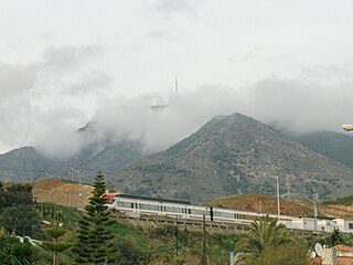
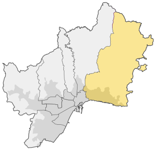
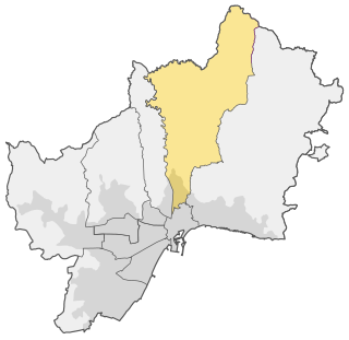
Churriana, also known as District 8, is one of the 11 districts of the city of Málaga, Spain. Churriana holds the Málaga Airport.

Málaga Municipality in Andalusia, Spain

Málaga is a municipality, capital of the Province of Málaga, in the Autonomous Community of Andalusia, Spain. With a population of 571,026 in 2018, it is the second-most populous city of Andalusia and the sixth-largest in Spain. The southernmost large city in Europe, it lies on the Costa del Sol of the Mediterranean, about 100 kilometres east of the Strait of Gibraltar and about 130 km (80.78 mi) north of Africa.

Spain Kingdom in Southwest Europe

Spain, officially the Kingdom of Spain, is a country mostly located on the Iberian Peninsula in Europe. Its territory also includes two archipelagoes: the Canary Islands off the coast of Africa, and the Balearic Islands in the Mediterranean Sea. The African enclaves of Ceuta, Melilla, and Peñón de Vélez de la Gomera make Spain the only European country to have a physical border with an African country (Morocco). Several small islands in the Alboran Sea are also part of Spanish territory. The country's mainland is bordered to the south and east by the Mediterranean Sea except for a small land boundary with Gibraltar; to the north and northeast by France, Andorra, and the Bay of Biscay; and to the west and northwest by Portugal and the Atlantic Ocean.

Málaga Airport international airport serving Costa del Sol, Malaga, Spain

Málaga Airport, officially Málaga–Costa del Sol Airport since June 2011, is the fourth busiest airport in Spain after Madrid–Barajas, Barcelona and Palma de Mallorca. It is an important airport for Spanish tourism as it is the main international airport serving the Costa del Sol. It is 8 km (5.0 mi) southwest of Málaga and 5 km (3.1 mi) north of Torremolinos. The airport has flight connections to over 60 countries worldwide, and over 14.4 million passengers passed through it in 2015. In 2017, 18.6 million passengers passed through Malaga Airport.

It comprises de following wards (barrios): Aeropuerto, Arraijanal, Buenavista, Butano, Campamento Benítez, Campo de Golf, Cañada de Ceuta, Cementerio Churriana, Churriana, Cortijo de Mazas, Cortijo San Isidro, Cortijo San Julián, Depuradora Guadalhorce, El Cuartón, El Higueral, El Olivar, El Retiro, Finca La Hacienda, Finca Monsálvez, Guadalmar, Hacienda Platero, Heliomar, La Azucarera, La Casita de Madera, La Cizaña, La Noria, La Tosca, Las Espeñuelas, Las Pedrizas, Los Chochales, Los Jazmines, Los Manantiales, Los Paredones, Los Paseros, Los Rosales, Lourdes, Makro, Parque del Guadalhorce, Polígono Comercial Guadalhorce, Polígono Industrial Aeropuerto, Polígono Industrial El Álamo, Polígono Industrial El Tarajal, Polígono Industrial Guadalhorce, Polígono Industrial Haza de la Cruz, Polígono Industrial KM.239 Ctra. N-340, Polígono Industrial Mi Málaga, Polígono Industrial Santa Bárbara, Polígono Industrial Santa Cruz, Polígono Industrial Santa Teresa, Polígono Industrial Villa Rosa, Rojas, San Fernando, San Jerónimo, San Juan-El Albaricocal, San Julián, Santa Tecla, Vega de Oro, Wittenberg. [1]

El Cuartón Village in Andalusia, Spain

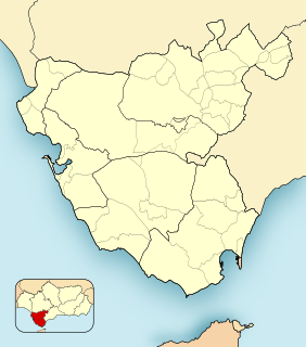
El Cuartón is a village in the municipality of Tarifa in the Province of Cadiz in southeastern Spain. It is located 13.7 kilometres (8.5 mi) by road southwest of the city centre of Algeciras, along the main road to the southern tip of Spain at Tarifa, which is 9.7 kilometres (6.0 mi) away, and it lies just to the southwest of El Bujeo. According to the National Statistics Institute, El Cuartón had 164 inhabitants in 2009.

<i>La Tosca</i> play by Victorien Sardou

La Tosca is a five-act drama by the 19th-century French playwright Victorien Sardou. It was first performed on 24 November 1887 at the Théâtre de la Porte Saint-Martin in Paris, with Sarah Bernhardt in the title role. Despite negative reviews from the Paris critics at the opening night, it became one of Sardou's most successful plays and was toured by Bernhardt throughout the world in the years following its premiere. The play itself is no longer performed, but its operatic adaptation, Giacomo Puccini's Tosca, has achieved enduring popularity. There have been several other adaptations of the play including two for the Japanese theatre and an English burlesque, Tra-La-La Tosca as well as several film versions.

Related Research Articles

Arcos de la Frontera Municipality in Andalusia, Spain

Arcos de la Frontera is a town and municipality in the Sierra de Cádiz comarca, province of Cádiz, in Andalusia, Spain. It is located on the Northern, Western and Southern banks of the Guadalete river, which flows around three sides of the city under towering vertical cliffs, to Jerez and on to the Bay of Cádiz. The town commands a fine vista atop a sandstone ridge, from which the peak of San Cristóbal and the Guadalete Valley can be seen. The town gained its name by being the frontier of Spain's 13th century battle with the Moors.

Cercanías Málaga railway line

Cercanías Málaga is a commuter rail service between central Málaga, Spain, and towns in the province. The network consists of 70 km of track, with two lines and 24 stations in operation. The trains are powered by overhead lines and run on broad Iberian gauge track.

Alhaurín el Grande Municipality in Andalusia, Spain

Alhaurín el Grande is a town located in the province of Málaga in the autonomous community of Andalusia in southern Spain.

San Juan Bautista Tuxtepec Place in Oaxaca, Mexico

San Juan Bautista Tuxtepec, or simply referred to as Tuxtepec, is the head of the municipality by the same name and is the second most populous city of the Mexican state of Oaxaca. It is part of the Tuxtepec District of the Papaloapan Region. As of the 2005 census, the city is home to a population of 94,209 and 144,555 in the municipality, though census data are often under reported for various reasons. The municipality resides in the region called La Cuenca, is located 36 feet above sea level, and occupies an area of approximately 580 square miles (1,500 km2). The city itself is surrounded by the Papaloapan River, and lies a few kilometers south of the Cerro de Oro Dam on its tributary the Santo Domingo River. The municipality is bordered by the state of Veracruz in the north, the municipalities of Loma Bonita to the east and San José Chiltepec to the south. It is almost 100 miles (160 km) to the port of Veracruz, 130 miles (210 km) to Oaxaca City, the state capital, and 310 miles (500 km) to Mexico City.

El Cerrito, Valle del Cauca Municipality and town in Valle del Cauca Department, Colombia

El Cerrito is a town and municipality located in the Department of Valle del Cauca, Colombia. This is one of the 42 municipalities of the department.

Sarapiquí is the tenth canton in the province of Heredia in Costa Rica.

Pinotepa Nacional Municipality and town in Oaxaca, Mexico

Pinotepa Nacional is a city and seat of the municipality of the same name, in the Mexican state of Oaxaca.

Santiago Jamiltepec Municipality and town in Oaxaca, Mexico

Santiago Jamiltepec is a town, and the seat of surrounding municipality of the same name, in the Mexican state of Oaxaca. It is located in the Jamiltepec District in the west of the Costa Chica Region, 30 km east of Pinotepa Nacional on Federal Highway 200, and 460 km southwest of state capital Oaxaca de Juárez.

Valle del Guadalhorce Comarca in Andalusia, Spain

The Valle del Guadalhorce is a comarca in the province of Málaga, Andalusia, southern Spain. It includes 8 municipalities and is part of the natural region of the Guadalhorce river.

Bailén-Miraflores District of Málaga in Andalusia, Spain

Bailén-Miraflores, also known as District 4, is one of the 11 districts of the city of Málaga, Spain.

Carretera de Cádiz District of Málaga in Andalusia, Spain

Carretera de Cádiz, also known as District 7, is one of the 11 districts of the city of Málaga, Spain.

Centro (Málaga) District of Málaga in Andalusia, Spain

Centro, also known as District 1 and Málaga-Centro, is one of the 11 districts of the city of Málaga, Spain.

Este (Málaga) District of Málaga in Andalusia, Spain

Este, also known as District 2 and Málaga-Este, is one of the 11 districts of the city of Málaga, Spain.

Ciudad Jardín (Málaga) District of Málaga in Andalusia, Spain

Ciudad Jardín, also known as District 3, is one of the 11 districts of the city of Málaga, Spain.

Cruz de Humilladero District of Málaga in Andalusia, Spain

Cruz de Humilladero, also known as District 6, is one of the 11 districts of the city of Málaga, Spain.

Campanillas District of Málaga in Andalusia, Spain

Campanillas, also known as District 9, is one of the 11 districts of the city of Málaga, Spain.

Puerto de la Torre District of Málaga in Andalusia, Spain

Puerto de la Torre, also known as District 10, is one of the 11 districts of the city of Málaga, Spain.

Seville, the capital of the region of Andalusia in Spain, has 11 districts, further divided into 108 neighbourhoods.

References

Coordinates: 36°39′55″N4°29′25″W / 36.6652°N 4.4903°W / 36.6652; -4.4903

Geographic coordinate system Coordinate system

A geographic coordinate system is a coordinate system that enables every location on Earth to be specified by a set of numbers, letters or symbols. The coordinates are often chosen such that one of the numbers represents a vertical position and two or three of the numbers represent a horizontal position; alternatively, a geographic position may be expressed in a combined three-dimensional Cartesian vector. A common choice of coordinates is latitude, longitude and elevation. To specify a location on a plane requires a map projection.