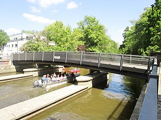

The Camsdorf Bridge (German : Camsdorfer Brücke) is a bridge over the Saale river in Jena, Germany. It connects the city center of Jena with the suburb of Wenigenjena and is considered to be the oldest stone arch bridge in Jena.


The Camsdorf Bridge (German : Camsdorfer Brücke) is a bridge over the Saale river in Jena, Germany. It connects the city center of Jena with the suburb of Wenigenjena and is considered to be the oldest stone arch bridge in Jena.


A wooden bridge spanned the Saale until the construction of the first stone bridge in the 15th century. In 1416, the bridge included a hermitage in which a man could request alms for the bridge. [1] The stone arch bridge was built around 1480 and consisted of nine arches. It was an important crossing over the Saale, which at that time often flooded its banks, and served to connect Jena to the settlements east of the city. The stones used in its construction originated from the remnants of castles on the Hausberg mountain which were destroyed in 1304.
This old Camsdorf bridge was included under the Latin name Pons as one of the Seven Wonders of Jena. It featured its own chapel, in which a stone or wooden cross stood until 1824 marking the border between the urban area and Camsdorf. In the guesthouse Grüne Tanne by the bridge, Goethe wrote Der Erlkönig .
In 1575, two additional arches were added on the Camsdorf side of the bridge.
The history of the original bridge also includes some tragic events:
With increasing development and industrialization during the 19th century, the need for a new bridge was recognized. The majority of the contemporary population however regarded the Camsdorf Bridge as a valuable historical monument which should be preserved. [4]
To handle the growing traffic, the old bridge was demolished in July 1912 and its replacement was completed by November 1913. On the southwest pillar of the bridge, a small pavilion was erected containing a statue of the Archangel Michael, patron saint of Jena. In addition to regular vehicle and pedestrian traffic, the new bridge supported a tram line connecting Jena and Weningenjena.
The rebuilt bridge was destroyed in 1945 by Wehrmacht sappers in an effort to obstruct the eastward progress of Allied armies. Its destruction was nevertheless tactically useless as the Americans had already crossed the Saale elsewhere at Kunitz. The damage was surveyed in the weeks immediately following the war, and the bridge was quickly rebuilt in 1946 with Soviet help. The rebuilt bridge was dubbed the "Bridge of German-Soviet Friendship" and was the first structure in Jena rebuilt after the war.
For many years, the Camsdorf Bridge was the only crossing over the Saale in the vicinity of Jena which heavy vehicles could traverse.
The bridge was extensively renovated in 2005 as a result of serious wear. The tram line was also expanded, from a single to a double lane. Upon its reopening in 2005, a festival was held on the bridge for the first time.

Jena is a city in Germany and the second largest city in Thuringia. Together with the nearby cities of Erfurt and Weimar, it forms the central metropolitan area of Thuringia with approximately 500,000 inhabitants, while the city itself has a population of about 110,000. Jena is a centre of education and research; the university was founded in 1558 and had 18,000 students in 2017 and the Ernst-Abbe-Fachhochschule Jena counts another 5,000 students. Furthermore, there are many institutes of the leading German research societies.

Schöllenen Gorge is a gorge formed by the upper Reuss in the Swiss canton of Uri between the towns of Göschenen to the north and Andermatt to the south. It provides access to the St Gotthard Pass.

The Reichsbrücke is a major bridge in Vienna, linking Mexikoplatz in Leopoldstadt with the Donauinsel in Donaustadt across the Danube. The bridge is used by 50,000 vehicles per day and carries six lanes of traffic, U-Bahn tracks, two footpaths, two cyclepaths and two utility tunnels.

Julius-Leber-Brücke is a railway station in the Schöneberg district of Berlin. Located under a bridge over the cutting created for the Berlin-Potsdam-Magdeburg railway. It was officially opened on 2 May 2008 and is served by the S-Bahn line S1.

The Großheringen–Saalfeld railway, also known as the Saalbahn, is a 153 kilometre-long double-track main line in the German state of Thuringia. It connects the Thuringian Railway at Großheringen with the Franconian Forest Railway (Frankenwaldbahn) at Saalfeld and is part of the north–south main line, Munich–Nuremberg–Halle / Leipzig–Berlin. It is electrified at 15 kV. 16.7 Hz.
The Halle–Bebra railway, known in German as the Thüringer Bahn, is a 210 kilometre-long railway line from Halle (Saale) via Erfurt and Gerstungen to Bebra, mainly in Thuringia. As far as Gerstungen the line originally belonged to the Thuringian Railway Company. From Gerstungen to Bebra, it was owned by the Frederick William Northern Railway (Friedrich-Wilhelms-Nordbahn), named after the Prussian king, Frederick William IV. It is now a two-track, electrified, standard gauge mainline operated by DB Netze. It was opened between 1846 and 1849 and was the first railway line in Thuringia. All types of trains from Regionalbahn to ICE currently run on the line except Interregio-Express. Four of the six largest cities in Thuringia are located on the line.

Jena Paradies station is the main railway station of the city of Jena in the German state of Thuringia. It is on the Saal Railway and is served by two long-distance services each day and regional trains to and from Naumburg, Saalfeld and Pößneck. It is named after and adjacent to Paradies ("paradise") Park, which is on the eastern shore of the Saale river.

The Weimar–Gera railway is a line in the German state of Thuringia, connecting the city of Weimar via Jena, Stadtroda and Hermsdorf to Gera. It was built by the Weimar-Gera Railway Company, which was founded in June 1872, and the line was officially accepted into operation in June 1876.

Jena West station is to the west of the centre of the city of Jena in the German state of Thuringia at the 22.59 km mark of the Weimar–Gera railway between Weimar, Jena-Göschwitz station and Gera Hauptbahnhof. This line is also called the Holzland Railway and it is part of the Mid-German Connection. The station is located in the suburb of Jena-Süd.

Jena-Göschwitz station is a railway station in city of Jena in the German state of Thuringia. It is located 152.21 metres above sea level, 32.22 km from Großheringen on the Saal Railway and 27.50 from Weimar station on the Weimar–Gera railway. It opened on 1 July 1876 and is classified by Deutsche Bahn as a category 4 station.

The Stone Bridge in Regensburg, Germany, is a 12th-century bridge across the Danube linking the Old Town with Stadtamhof. For more than 800 years, until the 1930s, it was the city's only bridge across the river. It is a masterwork of medieval construction and an emblem of the city.

Nikolaus Gromann was an architect of the German Renaissance who served at the court of John Frederick I, Elector of Saxony. He also worked for John Frederick's descendants residing in the cities of Weimar, Gotha and Altenburg, thus spending more than 30 years in the service of the House of Wettin.

Münsterbrücke is a pedestrian and road bridge over the Limmat in the city of Zürich, Switzerland. It is listed in the Swiss inventory of cultural property of national and regional significance. It is indirectly named after two Münster (minsters), the Fraumünster and Grossmünster.

The Karl Theodor Bridge, commonly known as the Old Bridge, is an arch bridge in Heidelberg that crosses the Neckar river. It connects the Old City with the eastern part of the Neuenheim district of the city on the opposite bank. The current bridge, made of Neckar sandstone and the ninth built on the site, was constructed in 1788 by Elector Charles Theodore, and is one of the best-known landmarks and tourist destinations in Heidelberg.

The Seven Wonders of Jena are seven attractions associated historically with the Thuringian university town Jena.

The Kronenbrücke was built on the site of the original bridge which crossed the Dreisam and was one of the two oldest bridges in Freiburg im Breisgau, a city on the edge of the Black Forest in the Baden-Württemberg region of Germany. In 1869, an iron bridge with stone substructure replaced the original wooden bridge across the River Dreisam. This, however, lasted only three years due to excessive flooding and the replacement erected was Gartenstraßen. After extensive work was done to dams and shores to prevent the bridge collapsing in the manner of its predecessor and the building of two others, to reduce frequent stressing, the now renamed Friedrichsbrücke, named after Grand Duke Frederick, opened in 1903. Despite hopes of the bridge lasting for centuries, it was replaced due to a variety of reasons in 1962 with the removal of its base done in 1967, and final construction completed in 1969. The new bridge was the Kronenbrücke an oval-shaped twin bridge, enhancing traffic management and navigation on the inner city ring road. History was soon to be repeated as the current incarnation was unable to be modified to allow a planned tram line. The Kronenbrücke was demolished in 2015 to make way for a new economical bridge featuring a tram line. Its replacement, also called Kronenbrücke, has a simpler straight road guidance system which allowed a more economical bridge size.

Alte Brücke is a bridge in Frankfurt, Hesse, Germany. It is the oldest bridge over the lower course of the river Main, and until 1886 was the only stone bridge crossing the river. From the Middle Ages until the year 1914, it connected the "Fahrgasse" in Frankfurt Altstadt with the "Brückenstraße" in Sachsenhausen. Since its first mention in official documents in 1222, the development of Frankfurt has been strongly influenced by the bridge. Over the centuries, Alte Brücke has been destroyed and reconstructed at least 18 times. With its 13 brick-built circular arches, the Sachsenhausen Bridge was one of the most prominent buildings of the city, but failing to meet the increasing demands of the modern road and ship traffic, it was demolished in 1914.

The Friendship Bridge is a bridge which crosses the Saar river, south of Saarbrücken, and links the Saarland municipality of Kleinblittersdorf with the Lorraine commune of Grosbliederstroff.

Johannisberg is a prominent ridge of the Wöllmisse, a Muschelkalk plateau east of Jena. The steeply sloping spur of land to the Saale Valley north of the district of Alt-Lobeda bears the remains of two important fortifications from the late Bronze Age and the early Middle Ages. Due to several archaeological excavations and finds recovered since the 1870s, they are among the few investigated fortifications from these periods in Thuringia. Of particular interest in archaeological and historical research is the early medieval castle. Due to its location directly on the eastern bank of the Saale, its dating and interpretation were and are strongly linked to considerations of the political-military eastern border of the Frankish empire. It is disputed whether it was a fortification of independent Slavic rulers or whether it was built under Frankish rule. According to a recent study, it may have been built in the second half of the 9th century in connection with the establishment of the limes sorabicus under Frankish influence.

The Saints Bridge is a footbridge in Leipzig. It crosses the Elstermühlgraben, which utilises the old course of the White Elster.