Duluth is a port city in the U.S. state of Minnesota and the county seat of St. Louis County. Located on Lake Superior in Minnesota's Arrowhead Region, the city is a hub for cargo shipping. Commodities shipped from the Port of Duluth include coal, iron ore, grain, limestone, cement, salt, wood pulp, steel coil, and wind turbine components. Duluth is south of the Iron Range and the Boundary Waters Canoe Area Wilderness.

The Aerial Lift Bridge, earlier known as the Aerial Bridge or Aerial Ferry Bridge, is a landmark in the port city of Duluth, Minnesota. The span began life in 1905 as the United States' first transporter bridge: Only one other was ever constructed in the country, Sky Ride in Chicago. The span was converted in 1929–1930 to a vertical-lift bridge, also rather uncommon, although there are six such bridges along Ontario's Welland Canal. It remains in operation. The bridge is owned and operated by the City of Duluth. The bridge was added to the National Register of Historic Places on May 22, 1973. The United States Army Corps of Engineers maintains a nearby maritime museum.

USCGC Sundew (WLB-404) was a 180-foot (55 m) sea going buoy tender (WLB). An Iris, or C-class tender, it was built by Marine Iron and Shipbuilding Corporation in Duluth, Minnesota, United States. Sundew's preliminary design was completed by the United States Lighthouse Service and the final design was produced by Marine Iron and Shipbuilding Corporation in Duluth for the U.S. Coast Guard. On 29 November 1943 the keel was laid. It was launched on 8 February 1944 and commissioned on 24 August 1944. The original cost for the hull and machinery was $861,589.
Duluth Entertainment Convention Center (DECC) is a multi-purpose arena and convention center complex located in Duluth, Minnesota. It has been home to the University of Minnesota Duluth Bulldog men's hockey team since 1966. The DECC is located on the waterfront near Duluth's famous Aerial Lift Bridge.
Lincoln Park is one of the larger neighborhoods in the city of Duluth, Minnesota, United States.

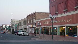
The downtown of Duluth, Minnesota, United States, is situated between Mesaba Avenue and 4th Avenue East; and located on Michigan, Superior, First, Second, and Third streets.

Duluth Heights is one of the largest neighborhoods in the city of Duluth, Minnesota, United States.

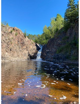
The Lester River, is a 19.3-mile-long (31.1 km) tributary of Lake Superior, in northeastern Minnesota in the United States. It drains an area of 58 square miles (150 km2).

The Wisconsin Point Light is a lighthouse located in Superior, on Wisconsin Point, in Douglas County, Wisconsin, United States.

Minnesota Point, also known as the Park Point neighborhood of Duluth, Minnesota, United States; is a long, narrow sand spit that extends out from the Canal Park tourist recreation-oriented district of the city of Duluth. The Point separates Lake Superior from Superior Bay and the Duluth Harbor Basin.
Lakeside – Lester Park is a neighborhood in Duluth, Minnesota, United States.

The Mataafa Storm of 1905, was a storm that occurred on the Great Lakes on November 27–28, 1905. The system moved across the Great Basin with moderate depth on November 26 and November 27, then east-northeastward across the Great Lakes on November 28. Fresh east winds were forecast for the afternoon and evening of November 27, with storm warnings in effect by the morning of November 28. Storm-force winds and heavy snows accompanied the cyclone's passage. The storm, named after the steamship Mataafa, ended up destroying or damaging about 29 vessels, killing 36 seamen, and causing shipping losses of US$ 3.567 million on Lake Superior.
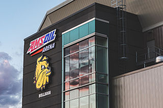
AMSOIL Arena is a multipurpose arena in Duluth, Minnesota, home to the UMD Men's and UMD Women's hockey teams. It opened in 2010, replacing the DECC Arena on the waterfront near Duluth's landmark Aerial Lift Bridge.
The Minnesota Point Light was a historic lighthouse on Minnesota Point in Duluth, Minnesota, United States, on the shores of Lake Superior. Built in 1858, it was the first lighthouse in the state, but is now a truncated ruined tower. The ruin was listed on the National Register of Historic Places in 1974 for its state-level significance in the theme of transportation. It was nominated for being the first high-powered lighthouse on Lake Superior, and the zero-point for all original surveys of the lake.
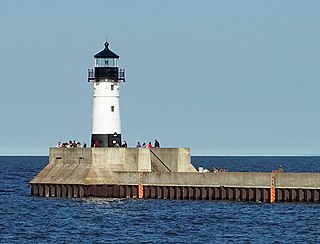
The Duluth Harbor North Pier Light is a lighthouse on the north breakwater of the Duluth Ship Canal in Duluth, Minnesota, United States.

The Duluth Ship Canal is an artificial canal cut through Minnesota Point, providing direct access to Duluth harbor from Lake Superior. Begun privately in 1871, it was put under federal supervision and maintenance several years later. It is still an important component of the harbor facilities.

The Duluth South Breakwater Inner Light is a lighthouse on the south breakwater of the Duluth Ship Canal in Duluth, Minnesota, United States. It forms a range with the Duluth South Breakwater Outer Light to guide ships into the canal from Lake Superior. The current structure was built from 1900 to 1901.

The Duluth South Breakwater Outer Light is a lighthouse on the south breakwater of the Duluth Ship Canal in Duluth, Minnesota, United States. It forms a range with the Duluth South Breakwater Inner Light to guide ships into the canal from Lake Superior.