West Duluth covers an area of 5,726 acres (23km2), or 13% of the city area, making it the third largest district in the city. Note that, as with many other Duluth neighborhood districts, the area is actually developed to a major extent is considerably smaller than the district figure. This is largely due to the harsh topography (hill) of the area.
The 2000 census enumerated 11,431 residents in the district, a 3% change from 1990. 23.8% of the population is under 18, and 15.7% over 65. 73.5% of households are owned, slightly higher than the city figure of 64.1%. The official figure places household density at just 0.85 / acre, but in most areas where development has actually taken place the density is much higher. As with the rest of the city, the housing stock tends to be very old by American standards, with a large percentage (most likely a majority) of homes having been built before 1939.
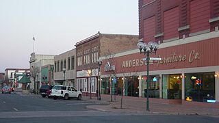
On a map, the core of West Duluth's "downtown", or center of activity, roughly forms a triangle, with the sides being Grand Avenue (State Highway 23), Central Avenue, and Bristol Street in Spirit Valley. This area is formed by two building styles, the first old, often joined buildings, usually containing small, locally owned stores on the first floor and apartments on the second (if present), and fronted by broad sidewalks. These occupy much of the Grand and Central avenue portions.
The other type, enclosed by Grand Avenue, Central Avenue, and facing Bristol Street on both sides consists of more recent construction resembling suburban sprawl, despite never sprawling, but only replacing older buildings. A strip mall, "Valley Shopping Center" is anchored by a Kmart store. A large sea of asphalt (parking lots and street), divided by buildings and concrete barriers, sits between the mall to other establishments, such as a large Super One supermarket.
Just outside the core is a new urbanist rowhouse development.
West Duluth's Spirit Valley business district is easily accessible from Interstate Highway 35 at Central Avenue.
The Spirit Valley neighborhood, according to the city's official map, follows Grand Avenue between 46th Avenue West and 59th Avenue West; and includes the entire area between Grand Avenue and Mike Colalillo Drive.
Education
West Duluth students attend Stowe Elementary School, Laura MacArthur Elementary School, Lincoln Park Middle School, and Duluth Denfeld High School. The local Catholic school is St. James, grades K–8, affiliated with the parish of the same name.
An exception to this is the Bayview Heights neighborhood, where students attend Proctor's public schools.
Restoration
Roads & Streets
In 2004, a large section of 59th Avenue West was given new road surface pavement.
In the summer of 2005, a large portion of Grand Avenue was given new road surface pavement. A stretch from 46th Avenue West to 59th Avenue West was entirely re-paved. The street lane format was altered, new stoplights were put in, new sidewalks were poured, as well as the addition of newer lamp posts.
In the spring of 2006, construction started on the second phase of Grand Avenue. A section from 40th Avenue West to 46th Avenue West was redone. This project also repaired the sewage lines for several homes in the area.
In the summer of 2010, a $66 million 3-year project went underway to reconstruct a large section of Interstate Highway 35 in West Duluth. All pavement was torn up and replaced, along with many concrete guardrails. Unused railroad bridges were removed, and many freeway entrance and exit ramps were given new pavement. The Minnesota Department of Transportation referred to the 2010–2012 road construction project in the media as the "Interstate 35 Mega Project" in Duluth.
In 2014, 57th Avenue West, between Cody Street and Highland Street, was reconstructed with new road surface pavement.
Spirit Valley Days
The Spirit Valley Days festival takes place every August in West Duluth.
Duluth is a port city in the U.S. state of Minnesota and the county seat of St. Louis County. Located on Lake Superior in Minnesota's Arrowhead Region, the city is a hub for cargo shipping. Commodities shipped from the Port of Duluth include coal, iron ore, grain, limestone, cement, salt, wood pulp, steel coil, and wind turbine components. Duluth is south of the Iron Range and the Boundary Waters Canoe Area Wilderness.
Interstate 35 (I-35) is a major Interstate Highway in the central United States. As with most primary Interstates that end in a five, it is a major cross-country, north–south route. It stretches from Laredo, Texas, near the Mexican border to Duluth, Minnesota, at Minnesota State Highway 61 and 26th Avenue East. The highway splits into I-35E and I-35W in two separate places, the Dallas–Fort Worth metroplex in Texas and at the Minnesota twin cities of Minneapolis–Saint Paul.
Minnesota State Highway 23 (MN 23) is a state highway that stretches from southwestern to northeastern Minnesota. At 343.723 miles (553.169 km) in length, it is the second longest state route in Minnesota, after MN 1.
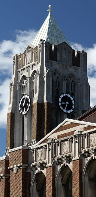
Duluth Denfeld High School, also known as Denfeld High School, is one of two high schools in Duluth, Minnesota along with Duluth East as of 2011 after the closure of Duluth Central and the previous closing of Morgan Park HS in 1982. Serving over 1000 students from grades nine to twelve, Denfeld High School has become a West Duluth landmark. The school is known for its architecture, including a historic auditorium and a 120-foot clock tower visible from Grand Avenue.
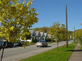
The Denfeld neighborhood is located within the West Duluth district of Duluth, Minnesota, United States. It consists mostly of closely spaced single-family residential homes, although a fair number of such houses have an area within the domicile registered as a rental unit. There are also a number of stores and businesses in the neighborhood concentrated along Grand Avenue.
Lincoln Park is one of the larger neighborhoods in the city of Duluth, Minnesota, United States.
The downtown of Duluth, Minnesota, United States, is situated between Mesaba Avenue and 4th Avenue East; and located on Michigan, Superior, First, Second, and Third streets.
Central Hillside is a neighborhood in Duluth, Minnesota, United States; located directly uphill from the city's downtown. The neighborhood offers views of the city and lake.
Minnesota State Highway 194 is a 17.392-mile-long (27.990 km) highway in northeast Minnesota, which runs from its intersection with U.S. Highway 2 in Solway Township and continues east to its eastern terminus at its Mesaba Avenue interchange with Interstate Highway 35 in downtown Duluth. For part of its route, it runs together with U.S. Highway 53.
The Spirit Valley neighborhood and business district is located within the West Duluth district of Duluth, Minnesota, United States.
Norton Park is a neighborhood in Duluth, Minnesota, United States.
The Cody neighborhood is located within the West Duluth district of Duluth, Minnesota, United States.
The Irving neighborhood is located within the West Duluth district of Duluth, Minnesota, United States. Raleigh Street, Central Avenue, and 59th Avenue West are three of the main routes in the community.
The Oneota neighborhood is located within the West Duluth district of Duluth, Minnesota, United States. The neighborhood was named for the prehistoric Oneota Native American culture.
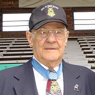
Michael Colalillo was a United States Army soldier and a recipient of the United States military's highest decoration – the Medal of Honor – for his actions during World War II.
U.S. Highway 169 (U.S. 169) is a major north–south highway in the U.S. state of Minnesota, connecting the Minnesota River valley with the Twin Cities and the Iron Range. Much of the route is built to expressway or freeway standards.
The city of Duluth, Minnesota has several distinct neighborhoods, and are typically divided into several main areas: Central, Eastern Duluth, Above the Hill, West Duluth, West of West Duluth, and Lincoln Park. This article lists each neighborhood.
King Field is a neighborhood in the Southwest community in Minneapolis, Minnesota. Its boundaries are 36th Street to the north, Interstate 35W to the east, 46th Street to the south, and Lyndale Avenue to the west. King Field, within the King Field neighborhood is a park named after Martin Luther King Jr.
Interstate 35 (I-35) is a north–south Interstate Highway that stretches from Laredo, Texas, to Duluth, Minnesota. In the US state of Minnesota, I-35 enters from Iowa and heads north toward the twin cities of Minneapolis and Saint Paul. South of the metropolitan area, I-35 splits into two branches; I-35E runs through Saint Paul and I-35W through Minneapolis. These two branches rejoin north of the Twin Cities, and the highway continues north to Duluth, where it terminates at State Highway 61 (MN 61). The highway was authorized in 1956 and the first segment opened in 1958. It reached Duluth in 1971, and the final segment to east Duluth opened in 1992.
This page is based on this Wikipedia article Text is available under the CC BY-SA 4.0 license; additional terms may apply. Images, videos and audio are available under their respective licenses.