Duluth Ship Canal

Last updated
Duluth Ship Canal
CSL laker at Duluth.jpg
SS Tarantau entering the Duluth Ship Canal from the lake. The two entrance lights can be seen at the end of the piers, while the museum building is at the left.
Duluth Ship Canal
Location Duluth, Minnesota
Country United States
Coordinates 46°46′46″N92°5′29″W / 46.77944°N 92.09139°W / 46.77944; -92.09139 (Duluth Ship Canal) Coordinates: 46°46′46″N92°5′29″W / 46.77944°N 92.09139°W / 46.77944; -92.09139 (Duluth Ship Canal)
Specifications
Length0.33 miles (0.53 km)
LocksNone
StatusOpen
History
Current owner U.S. Army Corps of Engineers
Construction began1870
Date completed1871
Geography
Start point Lake Superior
End point Duluth Harbor Basin

The Duluth Ship Canal is an artificial canal cut through Minnesota Point, providing direct access to Duluth harbor from Lake Superior. Begun privately in 1871, it was put under federal supervision and maintenance several years later. It is still an important component of the harbor facilities.

Contents

In its current configuration, the canal is defined by a pair of breakwaters 1,720 feet (520 m) long and 300 feet (91 m) apart, constructed of concrete set on timber and stone cribbing. [1] The canal is maintained at 245 feet (75 m) wide and 28 feet (8.5 m) LWD, allowing passage of ocean-going ships. [2] Three lighthouses are placed on the sides of the canal: the Duluth North Pier Light and the Duluth South Breakwater Outer Light mark the lake ends of the canal, while the Duluth South Breakwater Inner Light functions with the south breakwater light as a range light. At the harbor end, the canal is straddled by the Aerial Lift Bridge which connects Minnesota Point to the rest of the city. On the north side, there is a building housing the local Corps of Engineers administration, as well as the Lake Superior Maritime Visitor Center. There are no locks; most ships transit the canal under their own power, though tug service is available in case of adverse weather. [3] Around a thousand vessels a year ship from the Duluth–Superior port. [4]

History

U.S. Army Corps of Engineers barge in the canal, looking towards Duluth. Duluth canal.jpg
U.S. Army Corps of Engineers barge in the canal, looking towards Duluth.
USCGC Mackinaw entering the harbor from the canal, beneath the Aerial Lift Bridge. The rear range light can be seen behind it. USCGC Mackinaw Entering Duluth Harbor.jpg
USCGC Mackinaw entering the harbor from the canal, beneath the Aerial Lift Bridge. The rear range light can be seen behind it.

The construction of the first locks on the St. Marys River in 1855 allowed for navigation between the lakes, and Superior Bay presented itself as an attractive harbor. From the point of view of Duluth residents, however, arrangements were less than satisfactory, as ships from that city had to pass Superior, Wisconsin on the way to the lake, as the only natural outlet was between Minnesota Point and Wisconsin Point at the far end of the bay. Also, while sheltered, the bay was not naturally as deep as was desirable, and the canal was convoluted. In 1865 a harbor was constructed outside the bay using a breakwater, and this was gradually improved over the next several years. A storm in 1871 destroyed the structure, and though it was rebuilt the next year, it was abandoned in 1878 due to ongoing ice and storm damage. [5]

An 1866 report by Lt. Col. W. F. Raynolds of the Bureau of Topographical Engineers recommended cutting a canal through Minnesota Point, but due to the cost, no action was taken. [5] Instead, a massive federal effort was undertaken to improve facilities in Superior. At the same time, the city of Duluth combined forces with the Lake Superior and Mississippi Railroad to dig a canal on their own. [5] [6] This began in 1870, and politicians in Wisconsin, seeing traffic through Superior threatened, went to the war department to have construction stopped, eventually obtaining an injunction on July 13, 1871. [5] [6] They were too late. The canal was completed two months earlier, with local lore holding that on April 30, 1871, a group of city residents, summoned by brewer (soon to be mayor) Sidney Luce, came to the site with shovels and picks and dug the first connection between the bay and the lake. [6] [7]

The injunction was soon lifted, at the cost of building a dike from Rice's Point to Minnesota Point, thus isolating the canal from the main flow of the Saint Louis River, which fed the bay and which formed the border between the rival cities. [6] The dike did not last long; it suffered ice damage from the start and was gradually removed in the course of dredging. [5] Federal responsibility for the latter, a result of the 1873 River and Harbor Act, gradually expanded into jurisdiction over all facilities in the area, with the Corps of Engineers taking over the canal in 1887. [5]

The canal remains under the control of the Corps of Engineers to the present. In 1889, however, an attempt was made by Wilhelm Boeing, a Detroit businessman, to charge tolls for use of the canal. Boeing, the father of aircraft manufacturer William Boeing, owned property on both sides of the canal as well as thousands of acres of timber near Chisholm, and in 1888 his attorney had a string stretched across the entry to the canal to claim the right to charge tolls. This came to nothing, but the following October, flyers were distributed to shipping offices stating that a rope would be stretched across the canal on the fifteenth of the month to deny passage to all vessels. It is unclear what Boeing's intentions were, or whether he carried out his threat; but in any case his death the next month ended the matter. [8]

The canal was, from the beginning, defined by piers along either side. These were initially timber cribs put in place by the city, albeit with some federal funding. They did not stand up to the harsh winter weather and required substantial maintenance every few years, up until an 1896 project to rebuild the canal. [5] It was this project that gave the two piers their present form, with the new south pier completed in 1901, and the north pier completed the following year. [5] In 1906 the present administration building was completed; this was enlarged in the 1940s, and a visitor's center and museum was added to that in 1973. [5] A maintenance yard was constructed on the south side of the canal. The Aerial Lift Bridge was constructed in 1905 to provide access to Minnesota Point, which was cut off from the mainland by construction of the canal. [6]

Related Research Articles

Duluth, Minnesota City in Minnesota, United States

Duluth is a port city in the U.S. state of Minnesota and the county seat of St. Louis County. Duluth is about 65 miles south of the Superior National Forest and the Sawtooth Mountains. It is a hub for tourism and cargo shipping. Commodities shipped from the Port of Duluth include coal, iron ore, grain, limestone, cement, salt, wood pulp, steel coil, and wind turbine components.

Duluth MN-WI Metropolitan Area Place in Minnesota and Wisconsin, United States

The Twin Ports of Duluth, Minnesota and Superior, Wisconsin, are located at the western part of Lake Superior and together are considered the largest freshwater port in the world. They are twin cities and seaports, connected to the Atlantic Ocean through the Great Lakes and the Saint Lawrence Seaway. The Twin Ports are at the core of the U.S. Census Bureau's "Duluth, MN-WI Metropolitan Statistical Area", which includes all of Wisconsin's Douglas County, and Minnesota's Carlton, Lake, and Saint Louis counties. With a 2020 census population of 291,638, the Duluth MSA ranked as the 170th largest metropolitan area in the United States. Approximately 6.7 million tourists visit Duluth alone each year, this does not account for surrounding suburbs such as Virginia, Two Harbors, Ely, or Hibbing.

Duluth, Missabe and Iron Range Railway

The Duluth, Missabe and Iron Range Railway (DM&IR), informally known as the Missabe Road, was a railroad operating in northern Minnesota and Wisconsin that used to haul iron ore and later taconite to the Great Lakes ports of Duluth and Two Harbors, Minnesota. Control of the railway was acquired on May 10, 2004, by the Canadian National Railway (CN) when it purchased the assets of Great Lakes Transportation.

Aerial Lift Bridge Transporter bridge in Duluth, Minnesota

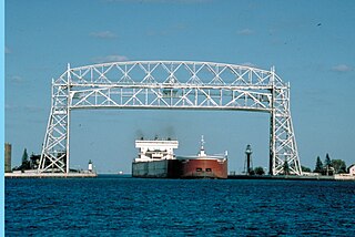
The Aerial Lift Bridge, earlier known as the Aerial Bridge or Aerial Ferry Bridge, is a landmark in the port city of Duluth, Minnesota. The span began life in 1905 as the United States' first transporter bridge: Only one other was ever constructed in the country, Sky Ride in Chicago. The span was converted in 1929–1930 to a vertical-lift bridge — also rather uncommon, although there are six such bridges along Ontario's Welland Canal — and continues to operate today. The bridge was added to the National Register of Historic Places on May 22, 1973. The bridge is owned and operated by the City of Duluth. The United States Army Corps of Engineers maintains a nearby maritime museum.

Split Rock Lighthouse History Museum in Two Harbors, Minnesota USA

Split Rock Lighthouse is a lighthouse located southwest of Silver Bay, Minnesota, USA on the North Shore of Lake Superior. The structure was designed by lighthouse engineer Ralph Russell Tinkham and was completed in 1910 by the United States Lighthouse Service at a cost of $75,000, including the buildings and the land. It is considered one of the most picturesque lighthouses in the United States.

Wisconsin Point Light

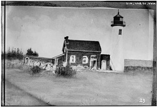
The Wisconsin Point Light is a lighthouse located near Superior, on Wisconsin Point, in Douglas County, Wisconsin, United States.

Minnesota Point Neighborhood in Duluth, Minnesota, United States of America

Minnesota Point, also known as the Park Point neighborhood of Duluth, Minnesota, United States; is a long, narrow sand spit that extends out from the Canal Park tourist recreation-oriented district of the city of Duluth. The Point separates Lake Superior from Superior Bay and the Duluth Harbor Basin.

Endion station

Endion station is a former train station in Duluth, Minnesota, United States. It was built in 1899 to serve the Endion neighborhood but was relocated to Canal Park in 1986 to make way for expansion of Interstate 35. Passenger service through the station had ceased in 1961 and freight service in 1978.

Lake Superior Maritime Visitor Center Maritime museum in Duluth, Minnesota

The Lake Superior Maritime Visitor Center is a museum in Duluth, Minnesota, operated by the United States Army Corps of Engineers. The museum is in Duluth's Canal Park near the Aerial Lift Bridge and overlooks the entrance to the Duluth-Superior harbor.

U.S. Army Corps of Engineers Duluth Vessel Yard United States historic place

The U.S. Army Corps of Engineers Duluth Vessel Yard is a federal port facility in Duluth, Minnesota, United States. It houses the United States Army Corps of Engineers (USACE) resources used to maintain the harbors of the Twin Ports of Duluth and Superior, Wisconsin. It was established on Minnesota Point in 1903, though most of its present configuration dates to a flurry of construction in 1941.

<i>Edna G</i>

Edna G is a tugboat which worked the Great Lakes and is now preserved as a museum ship. Edna G was built by the Cleveland Shipbuilding Company in 1896 for the Duluth and Iron Range Railroad at a cost $35,397.50. She was named for the daughter of J. L. Greatsinger, president of the railroad.

<i>Mataafa</i> Storm

The Mataafa Storm of 1905, was a storm that occurred on the Great Lakes on November 27–28, 1905. The system moved across the Great Basin with moderate depth on November 26 and November 27, then east-northeastward across the Great Lakes on November 28. Fresh east winds were forecast for the afternoon and evening of November 27, with storm warnings in effect by the morning of November 28. Storm-force winds and heavy snows accompanied the cyclone's passage. The storm, named after the steamship Mataafa, ended up destroying or damaging about 29 vessels, killing 36 seamen, and causing shipping losses of US$ 3.567 million on Lake Superior.

SS <i>Mataafa</i> Steam freighter that sank in Lake Superior

SS Mataafa was an American steamship that had a lengthy career on the Great Lakes of North America, first as a bulk carrier and later as a car carrier. She was wrecked in 1905 in Lake Superior just outside the harbor at Duluth, Minnesota, during a storm that was named after her. She was built as SS Pennsylvania in 1899, and renamed Mataafa when she was purchased in the same year by the Minnesota Steamship Company. After her 1905 wreck, she was raised and repaired, and served for another sixty years before being scrapped.

Minnesota Point Light Historic lighthouse ruin in Minnesota, United States

The Minnesota Point Light was a historic lighthouse on Minnesota Point in Duluth, Minnesota, United States, on the shores of Lake Superior. Built in 1858, it was the first lighthouse in the state, but is now a truncated ruined tower. The ruin was listed on the National Register of Historic Places in 1974 for its state-level significance in the theme of transportation. It was nominated for being the first high-powered lighthouse on Lake Superior, and the zero-point for all original surveys of the lake.

Duluth Harbor North Pier Light

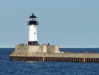
The Duluth Harbor North Pier Light is a lighthouse on the north breakwater of the Duluth Ship Canal in Duluth, Minnesota, United States.

Duluth South Breakwater Inner Light

The Duluth South Breakwater Inner Light is a lighthouse on the south breakwater of the Duluth Ship Canal in Duluth, Minnesota, United States. It forms a range with the Duluth South Breakwater Outer Light to guide ships into the canal from Lake Superior. The current structure was built from 1900 to 1901.

Duluth South Breakwater Outer Light

The Duluth South Breakwater Outer Light is a lighthouse on the south breakwater of the Duluth Ship Canal in Duluth, Minnesota, United States. It forms a range with the Duluth South Breakwater Inner Light to guide ships into the canal from Lake Superior.

Pokegama Lake Dam is a dam in Cohasset, Itasca County, Minnesota, northwest of the city of Grand Rapids.

<i>Essayons</i> (1908 tugboat) US Army Tugboat

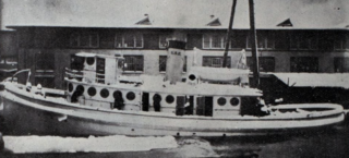
Essayons was a tugboat of the United States Army Corps of Engineers. Her mission with the Corps was to support the installation of breakwaters and piers, and the dredging of harbors on Lake Superior. She was built in 1908 and served with the Army until 1949, when she was sold to the Zenith Dredge Company. Essayons continued her support of port construction and maintenance under her new owner until the mid 1960s. In 1994 she was sold again, this time to a local businessman, who hoped to convert her into a floating Bed and Breakfast. This plan never came to fruition and she sank at her moorings in Duluth Harbor in 2009.

References

  1. Arkin, David Gerard (1987). "Site Plan of the Duluth Ship Canal". Historic American Engineering Record (Diagram). Washington, D.C.: Library of Congress. Retrieved September 17, 2021. HAER No. MN-10
  2. Chart 14975: Duluth–Superior Harbor (Map) (35th ed.). 1:15,000. Nautical chart. NOAA. December 2007.
  3. "Lake Superior: Charts 14966, 14975". United States Coast Pilot 6 (42nd ed.). NOAA: 434. 2012.
  4. "Duluth–Superior Harbor Statistics" (PDF). Duluth Seaway Port Authority. Retrieved 2012-04-27.
  5. 1 2 3 4 5 6 7 8 9 Demeter, C. Stephan (September 1993). "Duluth Ship Canal" (PDF). Historic American Engineering Record . Washington, D.C.: Library of Congress. Retrieved September 17, 2021.
  6. 1 2 3 4 5 Laakso, Kathy. "My cities by the bay: Superior was to be 'the next Chicago,' then Duluth committed an 'utterly lawless' deed". Zenith City Weekly.{{cite web}}: Missing or empty |url= (help)
  7. Federal Writers' Project (1940). "Duluth–Superior Harbor". The WPA Guide to the Minnesota Arrowhead Country. Minnesota Historical Society. Retrieved September 17, 2021.
  8. "Mr. Boeing's Canal" (PDF). Duluth Seaway Port Authority. 2004. Retrieved 2012-04-27.