
Portland Head Light is a historic lighthouse in Cape Elizabeth, Maine. The light station sits on a headland at the entrance of the primary shipping channel into Portland Harbor, which is within Casco Bay in the Gulf of Maine. Completed in 1791, it is the oldest lighthouse in Maine. The light station is automated, and the tower, beacon, and foghorn are maintained by the United States Coast Guard, while the former lighthouse keeper's house is a maritime museum within Fort Williams Park.
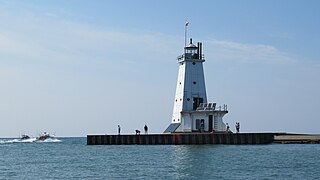
The Ludington Light is a 57-foot (17 m) tall steel-plated lighthouse in Ludington, Michigan, which lies along the eastern shores of Lake Michigan, at the end of the breakwater on the Pere Marquette Harbor. Given its location on the northern breakwater where the Pere Marquette River meets Lake Michigan, it is sometimes known as the Ludington North Breakwater Light. Underlying the building itself is a prow-like structure, which is designed to break waves.
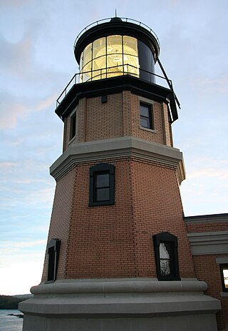
Split Rock Lighthouse is a lighthouse located southwest of Silver Bay, Minnesota, US on the North Shore of Lake Superior. The structure was designed by lighthouse engineer Ralph Russell Tinkham and was completed in 1910 by the United States Lighthouse Service for $75,000, including the buildings and the land. It is considered one of the most picturesque lighthouses in the United States.

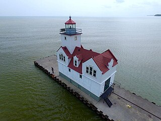
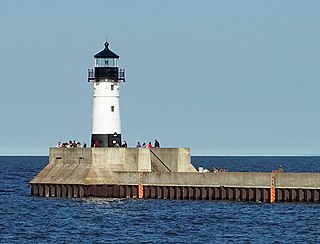
The Two Harbors Light is the oldest operating lighthouse in the US state of Minnesota. Overlooking Lake Superior's Agate Bay, the lighthouse is located in Two Harbors, Minnesota. The construction of the lighthouse began in 1891 and was completed the following year, with the light being lit for the first time on April 14, 1892. The first Two Harbors keeper was Charles Lederle and there were normally three keepers assigned to make sure the light was lit every day. The Lighthouse was built to provide safe passage into the Agate Bay Harbor during the early 20th century, as Two Harbors was a major shipping point for the iron ore of the Mesabi Range.

The New Presque Isle Light was built in 1870, at Presque Isle, Michigan, east of Grand Lake, and sits on the namesake peninsula. It is one of 149 lighthouses in Michigan, more than any other state. Because of changing shoreline particularly, or alternatively deterioration of the original building, it is not uncommon for a replacement lighthouse to be placed in the vicinity of an earlier light, in this case, the Old Presque Isle Light.

The Wisconsin Point Light is a lighthouse located in Superior, on Wisconsin Point, in Douglas County, Wisconsin, United States.
The Kewaunee Pierhead lighthouse is a lighthouse located near Kewaunee in Kewaunee County, Wisconsin. The lighthouse looks nearly identical to the Holland Harbor Lighthouse, except that it is colored white.

The Lynde Point Light or Lynde Point Lighthouse, also known as Saybrook Inner Lighthouse, is a lighthouse in Connecticut, United States, on the west side of the mouth of the Connecticut River on the Long Island Sound, Old Saybrook, Connecticut. The first light was a 35 feet (11 m) wooden tower constructed by Abisha Woodward for $2,200 and it was completed in 1803. A new lighthouse was eventually needed and a total of $7,500 was appropriated on July 7, 1838. Jonathan Scranton, Volney Pierce, and John Wilcox were contracted to build the new 65-foot (20 m) octagonal brownstone tower. It was constructed in 1838 and lit in 1839. The lighthouse was renovated in 1867 and had its keeper's house from 1833 replaced in 1858 with a Gothic Revival gambrel-roofed wood-frame house. In 1966, the house was torn down and replaced by a duplex house. The original ten lamps were replaced in 1852 with a fourth-order Fresnel lens, and with a fifth-order Fresnel lens in 1890. Lynde Point Lighthouse used whale oil until 1879 when it switched to kerosene. It was electrified in 1955 and fully automated by the United States Coast Guard in 1978. In 1990, it was added to the National Register of Historic Places and is significant for its "superior stone work in the tapering brownstone walls".

The Chicago Harbor Lighthouse is an automated active lighthouse, and stands at the south end of the northern breakwater protecting the Chicago Harbor, to the east of Navy Pier and the mouth of the Chicago River.

The Menominee North Pier lighthouse is located in the harbor of Menominee, Michigan. The station was first lit in 1877. The current structure and its still operational light was lit in 1927, and automated in 1972. It is also sometimes called the "Menominee (Marinette) North Pierhead Light".
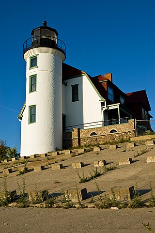
Point Betsie Light is located on the northeast shore of Lake Michigan — at the southern entrance to the Manitou Passage — north of Frankfort in Benzie County in Northern Michigan. Construction began in 1854, but it was not completed until 1858, and began service in the shipping season of 1859. The lighthouse cost $5,000 to build. In 1875, a life saving station was built for $3,000.

The Harbor Beach Lighthouse is a "sparkplug lighthouse" located at the end of the north breakwall entrance to the harbor of refuge on Lake Huron. The breakwall and light were created by the United States Army Corps of Engineers to protect the harbor of Harbor Beach, Michigan, which is the largest man-made freshwater harbor in the world. Harbor Beach is located on the eastern edge of the Thumb of Huron County, in the state of Michigan.

The Marquette Harbor Light is located on Lake Superior in Marquette, Michigan, a part of the Upper Peninsula. It is an active aid to navigation.
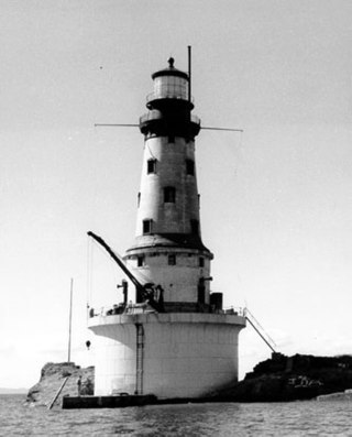
The Rock of Ages Light is a U.S. Coast Guard lighthouse on a small rock outcropping approximately 2.25 miles (3.62 km) west of Washington Island and 3.5 miles (5.6 km) west of Isle Royale, in Eagle Harbor Township, Keweenaw County, Michigan. It is an active aid to navigation.

The Port Washington Breakwater Light is a lighthouse built in 1935 at the entrance to the Port Washington, Wisconsin harbor on Lake Michigan. The second tower at this location, it remains an active aid to navigation. It was listed on the National Register of Historic Places in 2018.

Rawley Point Light is a lighthouse located in Point Beach State Forest, near Two Rivers, Wisconsin. At 111 feet (34 m) tall, it is the tallest lighthouse on the Wisconsin Shore and it is listed on the National Register of Historic Places.
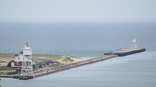
The Duluth Harbor North Pier Light is a lighthouse on the north breakwater of the Duluth Ship Canal in Duluth, Minnesota, United States.

The Duluth South Breakwater Inner Light is a lighthouse on the south breakwater of the Duluth Ship Canal in Duluth, Minnesota, United States. It forms a range with the Duluth South Breakwater Outer Light to guide ships into the canal from Lake Superior. The current structure was built from 1900 to 1901.
The Grand Marais Harbor of Refuge Inner and Outer Lights are a pair of lighthouses located on the west pier at the entry to Grand Marais Harbor of Refuge, in Grand Marais, Michigan. They were listed on the National Register of Historic Places in 2012.

The Racine Reef Light was a lighthouse located in Lake Michigan some two miles east of Racine, Wisconsin, marking the edge of its eponymous shallows. It was torn down in 1961 and replaced with a skeleton tower on the same foundation.


