
Grand Marais is a city in Cook County, Minnesota, United States, on the North Shore of Lake Superior. It had a population of 1,351 at the 2010 census.[6] It is the county seat and sole municipality of Cook County.[7] Before it was settled by French Canadians and before Minnesota's statehood, Grand Marais was inhabited by the Anishinaabe indigenous people, also known as the Ojibwe. The Ojibwe name for the area is Gichi-biitoobiig,[8] which means "great duplicate water," "parallel body of water" or "double body of water", a reference to the two bays that form this large harbor of Lake Superior.[9]
Minnesota State Highway 61 is a 148.843-mile-long (239.540 km) highway in northeast Minnesota, which runs from a junction with Interstate 35 (I-35) in Duluth at 26th Avenue East, and continues northeast to its northern terminus at the Canadian border near Grand Portage, connecting to Ontario Highway 61 at the Pigeon River Bridge. The route is a scenic highway, following the North Shore of Lake Superior, and is part of the Lake Superior Circle Tour designation that runs through Minnesota, Ontario, Michigan, and Wisconsin.
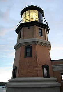
Split Rock Lighthouse is a lighthouse located southwest of Silver Bay, Minnesota, USA on the North Shore of Lake Superior. The structure was designed by lighthouse engineer Ralph Russell Tinkham and was completed in 1910 by the United States Lighthouse Service at a cost of $75,000, including the buildings and the land. It is considered one of the most picturesque lighthouses in the United States.

Grand Marais is an unincorporated community and census-designated place (CDP) in Alger County in the U.S. state of Michigan. It is located within Burt Township on the shores of Lake Superior, and the community is the eastern gateway to the Pictured Rocks National Lakeshore via H-58.

The Two Harbors Light is the oldest operating lighthouse in the US state of Minnesota. Overlooking Lake Superior's Agate Bay, the lighthouse is located in Two Harbors, Minnesota. The construction of the lighthouse began in 1891 and was completed the following year, with the light being lit for the first time on April 14, 1892. The first Two Harbors keeper was Charles Lederle and there were normally three keepers assigned to make sure the light was lit every day. The Lighthouse was built to provide safe passage into the Agate Bay Harbor during the early 20th century, as Two Harbors was a major shipping point for the iron ore of the Mesabi Range.
Crisp Point was one of five U.S. Life-Saving Service Stations along the coast of Lake Superior between Munising and Whitefish Point in the Upper Peninsula of Michigan. The lighthouse is within McMillan Township in Luce County.

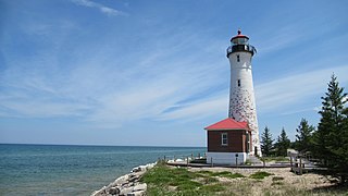
Au Sable Light is an active lighthouse in the Pictured Rocks National Lakeshore west of Grand Marais, Michigan off H-58. Until 1910, this aid to navigation was called "Big Sable Light".
Little Marais is an unincorporated community in Lake County, Minnesota, United States; located on the North Shore of Lake Superior.
Hovland is an unincorporated community in Cook County, Minnesota, United States.

Grand Marais/Cook County Airport is a county-owned public-use airport located eight miles (13 km) northwest of the central business district of Grand Marais, a city in Cook County, Minnesota, United States. This airport replaced the former Devil's Track Municipal Airport located on the shore of Devil's Track Lake, one mile (1.6 km) south of the current airport.
Grand Marais/Cook County Seaplane Base is a county-owned, public-use seaplane base located seven miles (11 km) northwest of the central business district of Grand Marais, a city in Cook County, Minnesota, United States.

Tofte is an unincorporated community in Tofte Township, Cook County, Minnesota, United States.

Schroeder is an unincorporated community in Schroeder Township, Cook County, Minnesota, United States.
Croftville is an unincorporated community in Cook County, Minnesota, United States.
Grand Portage is an unincorporated community in Cook County, Minnesota, United States; located on Grand Portage Bay of the North Shore of Lake Superior.
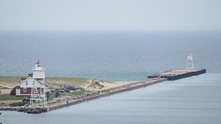
The Grand Marais Harbor of Refuge Inner and Outer Lights are a pair of lighthouses located on the west pier at the entry to Grand Marais Harbor of Refuge, in Grand Marais, Michigan. They were listed on the National Register of Historic Places in 2012.
Colvill is an extinct townsite in Cook County, Minnesota, United States.

Church of St. Francis Xavier is a historic church on Minnesota Highway 61 in Grand Marais, Minnesota, United States. The church began as a Jesuit mission from Fort William, Ontario, in 1855 to minister to the Ojibwe residents of the area. The permanent structure was built in 1895 and was used until declining attendance forced it to close in 1936. The Cook County Historical society restored the site between 1970 and 1974 and it was added to the National Register in 1986. The church is located in the abandoned townsite of Chippewa City.

The Jim Scott Fishhouse is a historic building in Grand Marais, Minnesota, United States, built in 1907 by a family-owned commercial fishing outfit. During the fishing season it served as a place to dress and pack fish, while over the winter it was used for the storage and repair of fishing gear. The Jim Scott Fishhouse was listed on the National Register of Historic Places in 1986 for having local significance in the theme of commerce. It was nominated for being a representative of the important commercial fishing industry on the upper North Shore of Lake Superior.

The North Shore Commercial Fishing Museum is a museum in Tofte, Minnesota, dedicated to the history of the Scandinavian immigrants and communities of the North Shore region of Lake Superior, and especially their importance to the national commercial fishing industry of the 1880s to 1940s. It is Minnesota's first museum dedicated to commercial fishing.


