Canal Parkway

Last updated

Canal Parkway

Maryland Route 61
Canal Parkway
Canal Parkway highlighted in red
Route information
Maintained by MDSHA
Length1.94 mi [1]  (3.12 km)
Existed2001–present
Tourist
routes
MD scenic byway.svg Chesapeake and Ohio Canal Scenic Byway
Major junctions
South endWV-28.svg WV 28 in Cumberland
North endMD Route 51.svg MD 51 in Cumberland
Location
Country United States
State Maryland
Counties Allegany
Highway system
MD Route 60.svg MD 60 MD Route 62.svg MD 62

Canal Parkway, which carries the unsigned Maryland Route 61 (MD 61) designation, is a state highway and automobile parkway in the U.S. state of Maryland. The road begins at the West Virginia state line at the North Branch Potomac River opposite Wiley Ford, where the highway continues south as West Virginia Route 28 (WV 28). The parkway runs 1.94 miles (3.12 km) north to MD 51 within the city of Cumberland. Canal Parkway provides a connection between downtown Cumberland and the South Cumberland neighborhood and with Greater Cumberland Regional Airport, which is located in Mineral County, West Virginia.

Contents

Canal Parkway was constructed as part of a broad group of projects to revitalize the North Branch Potomac River waterfront of Cumberland, centered on the historical Chesapeake and Ohio Canal (C&O Canal). The parkway was constructed both as a scenic highway and to improve access to South Cumberland and the airport, which were often cut off from the rest of Cumberland by flooding or traffic jams at the sole connecting point, a railroad underpass on Virginia Avenue. New bridges over the North Branch Potomac River and the C&O Canal were built in 1992 and 1997, while the portion of Canal Parkway from the canal crossing toward downtown Cumberland was constructed between 1999 and 2001.

Route description

Canal Parkway begins at the West Virginia state line on a bridge across the North Branch Potomac River between Wiley Ford and the southern edge of the city of Cumberland. The roadway continues south as WV 28 through Wiley Ford toward Greater Cumberland Regional Airport. Canal Parkway heads north as a two-lane highway, crossing the C&O Canal and its towpath on a Warren truss bridge. The state highway gains a median and intersects River Avenue, part of the old connection from Cumberland to Wiley Ford that serves the South Cumberland neighborhood. No trucks are allowed on the road north of River Avenue. Canal Parkway continues north between the C&O Canal to the west and an industrial area to the east, both of which are shielded from view by trees and walls. Beyond Elder Street, the state highway reduces to a two-lane road without a median. [1] [2]

View north from the south end of Canal Parkway at WV 28 at the West Virginia border on the bridge over the North Branch Potomac River in Cumberland 2016-05-05 14 43 46 View north across the Canal Parkway Bridge (Maryland State Route 61) crossing the North Branch Potomac River from Wiley Ford, Mineral County, West Virginia to Cumberland, Allegany County, Maryland.jpg
View north from the south end of Canal Parkway at WV 28 at the West Virginia border on the bridge over the North Branch Potomac River in Cumberland

As the parkway is approached by CSX's Cumberland Terminal Subdivision railroad line west of the Cumberland rail yard, the parkway ceases to be shielded by trees. Canal Parkway rises onto a retaining wall above the level of the C&O Canal to the west and on level with the railroad that begins to closely parallel the state highway to the east. The state highway's elevation allows views of the North Branch Potomac River and Knobly Mountain to the west but discourage views of the adjacent C&O Canal and MD 51 (Industrial Parkway), which parallels the east side of the railroad. Canal Parkway descends from the retaining wall to cross a rail spur from the Cumberland Terminal Subdivision that heads north to Canal Place. The two directions of the state highway split for a partial interchange with MD 51, with the northbound lane passing under MD 51's overpass of the railroad. The northbound lane of Canal Parkway has a right-in/right-out interchange with Wineow Street before merging with westbound MD 51 a short distance south of downtown Cumberland. [1] [2]

History

View south along Canal Parkway near Elder Street in Cumberland 2016-06-18 12 26 21 View south along Maryland State Route 61 (Canal Parkway) just north of Elder Street in Cumberland, Allegany County, Maryland.jpg
View south along Canal Parkway near Elder Street in Cumberland

Wiley Ford is named for a shallow spot in the North Branch Potomac River just east of the present bridge over the river. [3] The first bridge at Wiley Ford was constructed around 1908; a replacement bridge was built in the late 1950s. [4] [5] Traffic heading to Wiley Ford from downtown Cumberland travelled Virginia Avenue south from Oldtown Road, the old alignment of MD 51, then followed River Avenue southwest to its present intersection with Canal Parkway, then south across the river along Ford Avenue, which followed the same alignment as Canal Parkway today. [6] In addition to the route suffering from the standard problems of travelling through city streets, Virginia Avenue passed under the Baltimore and Ohio Railroad tracks via a low, narrow underpass that was vulnerable to flooding and, due to its location immediately south of Virginia Avenue's intersections with MD 51, was the frequent site of traffic jams. A problem at the underpass isolated South Cumberland south of the tracks from the rest of the city and required a lengthy detour through West Virginia. The same problems also hindered access to Greater Cumberland Regional Airport from the city. [7]

Canal Parkway was constructed as part of a broad group of projects to revitalize the North Branch Potomac River waterfront south of downtown Cumberland starting in 1989. [7] These projects included:

The first section of Canal Parkway to be built was the reconstruction of Ford Avenue from the West Virginia state line to River Avenue. A new bridge over the North Branch Potomac River was completed in 1992. [12] A new bridge over the C&O Canal was completed in 1997, eliminating an at-grade crossing of the highway and the C&O Canal towpath. [13] Construction of Canal Parkway from River Avenue to MD 51 was underway by 1999 and completed in 2001, at which time the highway received the unsigned MD 61 designation. [14] [15]

Junction list

The entire route is in Cumberland, Allegany County.

mi [1] kmDestinationsNotes
0.000.00South plate.svg
WV-28.svg
Airport Sign.svg WV 28 south Wiley Ford, Greater Cumberland Regional Airport
West Virginia state line at North Branch Potomac River; southern terminus
1.943.12West plate.svg
MD Route 51.svg
MD 51 west (Industrial Boulevard) Downtown Cumberland
Northern terminus; eastbound exit from and westbound entrance to MD 51
1.000 mi = 1.609 km; 1.000 km = 0.621 mi

Auxiliary routes

MD 61 originally had two auxiliary routes. Both routes were transferred to municipal maintenance in 2005. [16]

See also

Related Research Articles

<span class="mw-page-title-main">U.S. Route 340</span> US Numbered Highway in Virginia, West Virginia and Maryland, United States

U.S. Route 340 is a spur route of US 40, and runs from Greenville, Virginia, to Frederick, Maryland. In Virginia, it runs north–south, parallel and east of US 11, from US 11 north of Greenville via Waynesboro, Grottoes, Elkton, Luray, Front Royal, and Berryville to the West Virginia state line. A short separate piece crosses northern Loudoun County on its way from West Virginia to Maryland.

<span class="mw-page-title-main">Maryland Route 201</span> State highway in Prince Georges County, Maryland, United States

Maryland Route 201 is a state highway in the U.S. state of Maryland. Known for most of its length as Kenilworth Avenue, the highway runs 9.40 miles (15.13 km) from the District of Columbia boundary in Tuxedo, where the highway continues south as District of Columbia Route 295, north to MD 212 in Beltsville. MD 201 is a four to six-lane divided highway that connects Washington, D.C., with the northern Prince George's County municipalities of Cheverly, Bladensburg, Edmonston, Riverdale Park, College Park, Berwyn Heights, and Greenbelt. The highway also provides part of the connections from Interstate 95 (I-95)/I-495 to a pair of Washington Metro stations. MD 201 was built as two separate highways in the late 1920s: MD 201 from Washington, D.C., to Bladensburg and MD 205 from Bladensburg to Greenbelt. These highways, some of which became MD 769, were replaced with a relocated Kenilworth Avenue in the mid 1950s, including the Kenilworth Interchange with U.S. Route 50 and the Baltimore–Washington Parkway in Tuxedo. MD 201 was extended north to Beltsville in the early 1960s. The Maryland State Highway Administration (MDSHA) plans to extend MD 201 north toward Laurel.

<span class="mw-page-title-main">Clara Barton Parkway</span> Parkway in Maryland and Washington D.C.

Clara Barton Parkway is an automobile parkway in the U.S. state of Maryland and the District of Columbia. The highway runs 6.8 miles (10.9 km) from MacArthur Boulevard in Carderock, Maryland, east to Canal Road at the Chain Bridge in Washington. Clara Barton Parkway is a two- to four-lane parkway that parallels the Potomac River and the Chesapeake and Ohio Canal (C&O) in southwestern Montgomery County, Maryland, and the far western corner of Washington. The parkway provides access to the communities of Cabin John and Glen Echo and several units of the Chesapeake and Ohio Canal National Historical Park. The Maryland portion of the George Washington Memorial Parkway was constructed from Carderock past Interstate 495 (I-495) to Glen Echo in the early to mid-1960s. The parkway was proposed to continue west to Great Falls and east to Georgetown. However, these proposals never came to fruition and the parkway was extended only to the Chain Bridge in the early 1970s. The Maryland portion of the George Washington Memorial Parkway was renamed in 1989 for Clara Barton, the founder of the American Red Cross, and whose original headquarters is located in Glen Echo.

<span class="mw-page-title-main">West Virginia Route 28</span>

West Virginia Route 28 is a north–south route through the Potomac Highlands of the U.S. state of West Virginia. The southern terminus of the route is at West Virginia Route 39 in Huntersville. The northern terminus is at the Maryland state line in Wiley Ford, where the route continues into Cumberland as Canal Parkway upon crossing the North Branch Potomac River.

<span class="mw-page-title-main">West Virginia Route 480</span> Highway in West Virginia, United States

West Virginia Route 480 is a 5.64-mile-long (9.08 km) state highway in the U.S. state of West Virginia. Known for most of its length as Kearneysville Pike, the highway extends from WV 115 in Kearneysville north to the Maryland state line at the Potomac River in Shepherdstown, from where the highway continues as Maryland Route 34. The route is one of the main north–south highways of northern Jefferson County and passes through the campus of Shepherd University. WV 480 was originally established in the early 1920s as West Virginia Route 48. The highway was paved in the mid-1920s, which included a different routing through Shepherdstown. WV 48's present routing through the town was established in the late 1930s when the first James Rumsey Bridge was completed; that bridge was replaced with the current bridge in the mid-2000s. WV 48 was renumbered to WV 480 in the mid-1970s after U.S. Route 48 was established in West Virginia and Maryland.

<span class="mw-page-title-main">Maryland Route 135</span> State highway in the U.S. state of Maryland

Maryland Route 135 is a state highway in the U.S. state of Maryland. Known for most of its length as Maryland Highway, the state highway runs 29.00 miles (46.67 km) from U.S. Route 219 in Oakland in Garrett County east to US 220 in McCoole in Allegany County. MD 135 is the main link between the towns of Oakland, Mountain Lake Park, Loch Lynn Heights, and Deer Park on the Appalachian Plateau and the communities of Bloomington, Luke, Westernport, and McCoole in the upper valley of the North Branch Potomac River. These groups of towns are separated by Backbone Mountain.

<span class="mw-page-title-main">Maryland Route 190</span> Highway in Maryland, United States

Maryland Route 190 is a state highway in the U.S. state of Maryland. Known as River Road, the highway runs 15.88 miles (25.56 km) from MD 112 near Seneca east to Western Avenue at the District of Columbia boundary in Bethesda. MD 190 parallels the Potomac River through the affluent southwestern Montgomery County communities of Potomac and Bethesda and connects those suburbs with Interstate 495 (I-495). River Road was paved from Washington, D.C. west through part of Bethesda in the early 1910s. A second section of MD 190 was constructed through Potomac in the mid-1920s. The Bethesda and Potomac portions of the route were unified in the late 1920s. MD 190 was extended west toward Seneca in two steps in 1950 and the early 1970s. The highway was expanded to a four-lane divided highway through Bethesda in the early 1960s.

<span class="mw-page-title-main">Maryland Route 17</span> State highway in Frederick County, Maryland, US

Maryland Route 17 is a state highway in the U.S. state of Maryland. The state highway begins at the Virginia state line at the Potomac River in Brunswick, where the highway continues south as Virginia State Route 287. MD 17 runs 29.49 miles (47.46 km) north from the Brunswick Bridge to the Frederick–Washington county line near Wolfsville. The state highway serves as the main north–south highway of the Middletown Valley of western Frederick County. MD 17 connects Brunswick and Wolfsville with Rosemont, Burkittsville, Middletown, and Myersville. The state highway also connects those communities with the valley's main east–west highways, which include U.S. Route 340, US 40 Alternate, Interstate 70 (I-70), and US 40.

<span class="mw-page-title-main">Maryland Route 144</span> State highway in Maryland, US

Maryland Route 144 is a collection of state highways in the U.S. state of Maryland. These highways are sections of old alignment of U.S. Route 40 between Cumberland and Baltimore. Along with US 40 Scenic, US 40 Alternate, and a few sections of county-maintained highway, MD 144 is assigned to what was once the main highway between the two cities, connecting those endpoints with Hancock, Hagerstown, Frederick, New Market, Mount Airy, Ellicott City, and Catonsville. MD 144 has seven disjoint sections of mainline highway that pass through the Appalachian Mountains in Allegany and Washington counties and the rolling Piedmont of Frederick, Carroll, Howard, and Baltimore counties.

<span class="mw-page-title-main">U.S. Route 40 in Maryland</span> Section of U.S. Highway in Maryland, United States

U.S. Route 40 in the U.S. state of Maryland runs from Garrett County in Western Maryland to Cecil County in the state's northeastern corner. With a total length of 221 miles (356 km), it is the longest numbered highway in Maryland. Almost half of the road overlaps or parallels with Interstate 68 (I-68) or I-70, while the old alignment is generally known as US 40 Alternate, US 40 Scenic, or Maryland Route 144. West of Baltimore, in the Piedmont and Appalachian Mountains / Blue Ridge region of the Western Maryland panhandle of the small state, the portions where it does not overlap an Interstate highway are mostly two-lane roads. The portion northeast of Baltimore going toward Wilmington in northern Delaware and Philadelphia in southeastern Pennsylvania is a four-lane divided highway, known as the Pulaski Highway. This section crosses the Susquehanna River at the north end of the Chesapeake Bay on the Thomas J. Hatem Memorial Bridge.

<span class="mw-page-title-main">U.S. Route 15 in Maryland</span> Part of the U.S. Highway System in Maryland

U.S. Route 15 (US 15) is a part of the United States Numbered Highway System that runs from Walterboro, South Carolina, north to Painted Post, New York. In Maryland, the highway runs 37.85 miles (60.91 km) from the Virginia state line at the Potomac River in Point of Rocks north to the Pennsylvania state line near Emmitsburg. Known for most of its length as Catoctin Mountain Highway, US 15 is the primary north–south highway of Frederick County. The highway connects the county seat of Frederick with Point of Rocks, Leesburg, Virginia, and Charles Town, West Virginia, to the south and with Thurmont, Emmitsburg, and Gettysburg, Pennsylvania, to the north. US 15 is a four-lane divided highway throughout the state except for the portion between the Point of Rocks Bridge and the highway's junction with US 340 near Jefferson. The highway is a freeway along its concurrency with US 340 and through Frederick, where the highway meets US 40 and Interstate 70 (I-70). US 15 has a business route through Emmitsburg.

<span class="mw-page-title-main">U.S. Route 11 in Maryland</span> Section of U.S. Highway in Washington County, Maryland, U.S.

U.S. Route 11 (US 11) is a part of the United States Numbered Highway System that runs from New Orleans, Louisiana, to Rouses Point, New York. In Maryland, the federal highway runs 12.83 miles (20.65 km) from the West Virginia state line at the Potomac River in Williamsport north to the Pennsylvania state line near Maugansville. US 11 is the primary north–south surface highway in central Washington County, connecting Hagerstown with Williamsport to the south and Hagerstown Regional Airport to the north. The federal highway was once a major long-distance highway, but that role has been assumed by Interstate 81 (I-81), which parallels US 11 not only in Maryland but for most of its course from Tennessee to Upstate New York. US 11 is maintained by the Maryland State Highway Administration except for the municipally-maintained portions within the corporate limits of Williamsport and Hagerstown.

<span class="mw-page-title-main">Maryland Route 51</span> State highway in Allegany County, Maryland, US

Maryland Route 51 is a state highway in the U.S. state of Maryland. Known for most of its length as Oldtown Road, the state highway runs 25.53 miles (41.09 km) from an interchange with Interstate 68 (I-68) in Cumberland south to the West Virginia state line at the Potomac River, where the highway continues east as West Virginia Route 9 toward Paw Paw. Around Cumberland, MD 51 is a major highway that provides a bypass of the South End neighborhood of that city and access to industrial areas along the North Branch Potomac River. South of North Branch, MD 51 is a rural highway connecting small communities along the river in southeastern Allegany County, including Oldtown. Documentation from the Maryland State Highway Administration depict the highway as following an east-west alignment, but all signage indicates a north-south road.

<span class="mw-page-title-main">Maryland Route 34</span> State highway in Washington County, Maryland, US

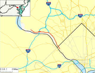
Maryland Route 34 is a state highway in the U.S. state of Maryland. Known for most of its length as Shepherdstown Pike, the state highway begins at the West Virginia state line at the Potomac River, where the highway continues south as West Virginia Route 480 through Shepherdstown. The state highway runs 9.95 miles (16.01 km) east to U.S. Route 40 Alternate in Boonsboro. MD 34 is the main east–west highway of southern Washington County, connecting Shepherdstown and Boonsboro with Sharpsburg and Keedysville. The state highway, which was preceded by the Boonsboro and Sharpstown Turnpike, was constructed as a modern highway in the late 1910s and early 1920s. MD 34's bypass of Keedysville opened around 1960. The western end of the state highway has had three bridges. A 19th-century bridge was destroyed in a 1936 flood and replaced by the James Rumsey Bridge in 1939. The present bridge, also named for James Rumsey, opened in 2005.

<span class="mw-page-title-main">Maryland Route 38</span> State highway in Garrett County, Maryland, US, known as Kitzmiller Rd

Maryland Route 38 is a state highway in the U.S. state of Maryland. Known as Kitzmiller Road, the state highway runs 5.67 miles (9.12 km) from the West Virginia state line at the North Branch Potomac River in Kitzmiller, where the highway continues south as West Virginia Route 42, north to MD 135 on top of Backbone Mountain. MD 38 connects Kitzmiller with the rest of Garrett County and across the North Branch Potomac River to Blaine and Elk Garden in western Mineral County. The state highway was constructed in the late 1920s and early 1930s. MD 38 originally ran from U.S. Route 219 near Thayerville through Deer Park and Altamont to Kitzmiller. The state highway was truncated at Backbone Mountain when MD 135 was extended west to Oakland in the mid-1950s.

<span class="mw-page-title-main">Maryland Route 63</span> State highway in Washington County, Maryland, US

Maryland Route 63 is a state highway in the U.S. state of Maryland. The state highway runs 16.99 miles (27.34 km) from MD 65 in Fairplay north to the Pennsylvania state line near Cearfoss, where the highway continues as Pennsylvania Route 163. MD 63 is an L-shaped route that passes through central Washington County on the south and west sides of Hagerstown. The state highway connects with multiple local and long-distance highways that serve Hagerstown, including Interstate 81 (I-81) and U.S. Route 11 in Williamsport and I-70 and US 40 in Huyett. MD 63 also joins MD 68 in a concurrency through Williamsport.

<span class="mw-page-title-main">U.S. Route 220 in Maryland</span> Highway in Maryland

U.S. Route 220 is a part of the U.S. Highway System that runs from Rockingham, North Carolina, to South Waverly, Pennsylvania. In Maryland, the federal highway runs 27.30 miles (43.94 km) from the West Virginia state line at the North Branch Potomac River in McCoole north to the Pennsylvania state line in Dickens. Known as McMullen Highway for much of its length in Maryland, US 220 is the primary north–south route in central Allegany County, connecting Cumberland with its southern suburbs and Keyser, West Virginia to the south and Bedford, Pennsylvania to the north. The federal highway is part of the National Highway System between the West Virginia state line and Maryland Route 53 in Cresaptown and between Interstate 68 (I-68), with which it is concurrent through Cumberland, and the Pennsylvania state line.

<span class="mw-page-title-main">Randolph Road</span> County highway in Montgomery County, Maryland, US

Randolph Road is a county highway in the U.S. state of Maryland. The highway is the major component of a mostly four- to six-lane 16.8-mile (27.0 km) highway spanning southern Montgomery County and northwestern Prince George's County that also includes Montrose Road, Josiah Henson Memorial Parkway, and Cherry Hill Road, and forms an important link between eastern Montgomery County and Rockville. Montrose Road begins at Maryland Route 189 in Potomac. The highway heads east through a junction with Interstate 270 (I-270) before the main course continues as Josiah Henson Memorial Parkway in North Bethesda. Josiah Henson Memorial Parkway continues through a junction with MD 355, east of which the highway becomes Randolph Road. Randolph Road intersects MD 586 and MD 185 in Wheaton, MD 97 in Glenmont, and MD 650 in Colesville. The highway continues southeast toward Fairland, where it meets U.S. Route 29. The highway continues from US 29 as Cherry Hill Road through an intersection with MD 212 in Calverton before reaching its eastern end at US 1 in College Park.

<span class="mw-page-title-main">Maryland Route 189</span> State highway in Montgomery County, Maryland, United States , known as Falls Road

Maryland Route 189 is a state highway in the U.S. state of Maryland. Known as Falls Road, the highway runs 5.05 miles (8.13 km) from MD 190 in Potomac to Great Falls Road and Maryland Avenue in Rockville. MD 189 connects Rockville with Potomac and the Great Falls of the Potomac River in southwestern Montgomery County. The highway was constructed from Rockville to Potomac by the early 1920s and extended toward Great Falls in the early 1930s. MD 189 was expanded to a divided highway around its newly-constructed interchange with Interstate 270 (I-270) in the late 1980s. The highway was truncated at both ends in the late 1990s.

References

  1. 1 2 3 4 Highway Information Services Division (December 31, 2013). Highway Location Reference. Maryland State Highway Administration. Retrieved 2010-11-07.
  2. 1 2 Google (2010-11-07). "Canal Parkway" (Map). Google Maps . Google. Retrieved 2010-11-07.
  3. Frostburg quadrangle (Map) (1898 ed.). 1:48,000. 15 Minute Series (Topographic). United States Geological Survey. Retrieved 2010-11-08.
  4. Special Dispatch to the Baltimore Sun (1908-01-13). "For Wiley's Ford Bridge". The Baltimore Sun. Baltimore: Tribune Company. p. 5.
  5. "Bridge Plan Is Protested". The Baltimore Sun. Baltimore: Tribune Company. 1957-06-20. p. 13.
  6. Street map of Cumberland (PDF) (Map). City of Cumberland, Maryland. 1938. Archived from the original (PDF) on 2011-04-26. Retrieved 2010-11-08.
  7. 1 2 3 "Canal Parkway, from Wiley Ford Bridge to MD 51". Context Sensitive Solutions. 2005. Retrieved 2008-09-01.
  8. "Chesapeake and Ohio Canal Rewatering Project Cumberland, Maryland". U.S. Army Corps of Engineers. Archived from the original on 2010-03-11. Retrieved 2010-11-08.
  9. "Scenic Railroad Prospers In Western Maryland; Rocky Gap Lodge Boosts Area's Tourist Business". The Baltimore Sun. Baltimore: Tribune Company. 1998-07-26. p. 12B.
  10. Loverro, Thom (1991-02-17). "Cumberland Studies Plans For Road, Park Along C&O Canal". The Baltimore Sun. Baltimore: Tribune Company. p. 8B.
  11. 1 2 "Western Maryland Briefs". The Baltimore Sun. Baltimore: Tribune Company. 1994-03-13. p. 11B.
  12. "NBI Structure Number: 100000010065010". National Bridge Inventory. Retrieved 2010-11-08.
  13. "NBI Structure Number: 100000010172010". National Bridge Inventory. Retrieved 2010-11-08.
  14. Maryland State Highway Administration (1999). Maryland: Official Highway Map (PDF) (Map) (1999–2000 ed.). Baltimore: Maryland State Highway Administration.
  15. 1 2 3 Highway Information Services Division (December 31, 2001). Highway Location Reference. Maryland State Highway Administration. Retrieved 2010-11-07.
  16. Highway Information Services Division (December 31, 2005). Highway Location Reference. Maryland State Highway Administration. Retrieved 2010-11-07.
  17. Google (2010-11-07). "Maryland Route 61A" (Map). Google Maps . Google. Retrieved 2010-11-07.
  18. Google (2010-11-07). "Maryland Route 61B" (Map). Google Maps . Google. Retrieved 2010-11-07.
Template:Attached KML/Canal Parkway
KML is from Wikidata