
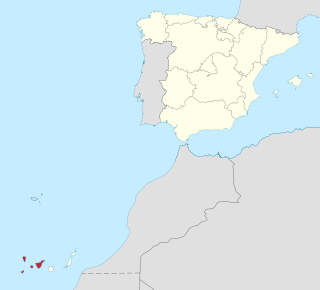
The Canary Islands, also known informally as the Canaries, are a Spanish region and archipelago in the Atlantic Ocean, in Macaronesia. At their closest point to the African mainland, they are 100 kilometres west of Morocco. They are the southernmost of the autonomous communities of Spain. The islands have a population of 2.15 million people and they are one of the outermost regions of the European Union.
Province of Santa Cruz de Tenerife, also Province of Santa Cruz, is a province of Spain, consisting of the western part of the autonomous community of the Canary Islands. It consists of about half of the Atlantic archipelago: the islands of Tenerife, La Gomera, El Hierro, and La Palma. It occupies an area of 3,381 km2 (1,305 sq mi). It also includes a series of adjacent roques.

Gran Canaria, also Grand Canary Island, is the third-largest and second-most-populous island of the Canary Islands, an archipelago off the Atlantic coast of Northwest Africa which is part of Spain. As of 2019 the island had a population of 851,231 that constitutes approximately 40% of the population of the archipelago. Las Palmas de Gran Canaria, the capital of the island, is the biggest city of the Canary Islands and the ninth of Spain.

Tenerife is the largest and most populous island of the Canary Islands. It is home to 43% of the total population of the archipelago. With a land area of 2,034 square kilometres (785 sq mi) and a population of 966,354 inhabitants at the end of 2020, it is also the most populous island of Spain and of Macaronesia.

Santa Cruz de Tenerife, commonly abbreviated as Santa Cruz, is a major city, capital of the island of Tenerife, Province of Santa Cruz de Tenerife, and capital of the Canary Islands. Santa Cruz has a population of 206,593 (2013) within its administrative limits. The urban zone of Santa Cruz extends beyond the city limits with a population of 507,306 and 538,000 within urban area. It is the second largest city in the Canary Islands and the main city on the island of Tenerife, with nearly half of the island's population living in or around it.

Lanzarote is a Spanish island, the northernmost and easternmost of the autonomous Canary Islands in the Atlantic Ocean. It is located approximately 125 kilometres off the north coast of Africa and 1,000 kilometres from the Iberian Peninsula. Covering 845.94 square kilometres, Lanzarote is the fourth-largest of the islands in the archipelago. With 152,289 inhabitants at the start of 2019, it is the third most populous Canary Island, after Tenerife and Gran Canaria. Located in the centre-west of the island is Timanfaya National Park, one of its main attractions. The island was declared a biosphere reserve by UNESCO in 1993. The island's capital is Arrecife, which lies on the eastern coastline. It is the smaller main island of the Province of Las Palmas.

The Pyramids of Güímar are six rectangular pyramid-shaped, terraced structures built from lava stone without the use of mortar. They are located in the district of Chacona, part of the town of Güímar on the island of Tenerife in the Canary Islands, Spain. The structures have been dated to the 19th century AD and they may originally have been a byproduct of contemporary agricultural techniques. These pyramids stand as high as 12m.

Tenerife North–Ciudad de La Laguna Airport, formerly Los Rodeos Airport, is the smaller of the two international airports on the island of Tenerife, Spain. It is located in San Cristóbal de La Laguna, 11 km (7 mi) by road from Santa Cruz and at an elevation of 633 metres (2,077 ft). It handled 3,717,944 passengers in 2012. Combined with Tenerife South Airport, the island gathers the highest passenger movement of all the Canary Islands, with 12,248,673 passengers, surpassing Gran Canaria Airport. Today TFN is an inter-island hub connecting all seven of the main Canary Islands with connections to the Iberian Peninsula and Europe.

San Bartolomé de Tirajana is a village and a Spanish municipality in the south-eastern part of the island of Gran Canaria in the Las Palmas province in the Canary Islands. With an area of 333.13 km2 (128.62 sq mi), San Bartolomé de Tirajana is the largest municipality in area on the island as well as the Canary Islands. The population is 56,698 (2013).

Garafía is a municipality in the island of La Palma, Santa Cruz de Tenerife. Located in the northwest of the island, in the middle od two whims of nature: the ravines of Franceses bordering Barlovento and Izcagua by the South, bordering Punta Gorda. The administrative capital, home to the City Council, is called Santo Domingo and has a length of 25.50 km coastline. with cliffs of incredible beauty but very steep and difficult to access, which can only be reached on foot, demanding a great effort to those not used to walking on rough terrain. Yes, their landscapes not leave anyone indifferent by the canopy of deep green vegetation that tupe those cliffs and see the ravines in contrast to the blue of the sky and its wild seas, as an example cited the gorgeous Beach Bujarén in Santo Domingo, with its roques; is the North of La Palma: a magical, unique, and unparalleled place.
A nature park, or sometimes natural park, is a designation for a protected natural area by means of long-term land planning, sustainable resource management and limitation of agricultural and real estate developments. These valuable landscapes are preserved in their present ecological state and promoted for ecotourism purposes.
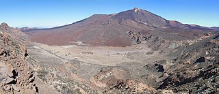
Teide National Park is a national park located in Tenerife, Canary Islands, Spain.

Malpaís de Güímar or Badlands of Guimar consist of a volcanic cone, subsidiary cones, and several basaltic lava flows in the Güímar municipality on the island of Tenerife, in the Canary Islands, Spain. They total in area about 290 hectares. The lava flows are quite recent, with the typical ʻaʻā type less than 10,000 years old. The large cone is called Montaña Grande and reaches a height of 276 m (906 ft).
Tourism is an essential part of the economy of the Canary Islands, a Spanish archipelago located in the Atlantic Ocean, 100 kilometres west of Morocco. Seven main islands and six islets make up the Canary Islands. They had more than 9 million foreign incoming tourists in 2007. Tourists seeking sunshine and beaches first began to visit the Canaries in large numbers in the 1960s. The Canary Islands are a leading European tourist destination with very attractive natural and cultural resources.
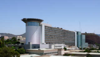
Hospital Universitario de Canarias or University Hospital of the Canary Islands it is a teaching hospital of general scope in Tenerife. Located in the city of San Cristóbal de La Laguna. Affiliated with the education and research network of the Universidad de La Laguna it is under the directive of the Servicio Canario de Salud. The hospital has specialist facilities which not only serve Tenerife but the surrounding Canary Islands.

The Roques de Anaga are two monolithic rocks forming some of the most emblematic natural monuments of Tenerife. Roque de Tierra stands 179 meters above sea level and is closer to the main island while Roque de Fuera, at 66 meters above sea level, is farther away. Both rocks are also included in the European Union's Natura 2000 ecological network of protected areas. They are located off the north-east coast of Tenerife.

The Barranco del Infierno is a ravine located in the town of Adeje in the south of the island of Tenerife, Canary Islands, Spain.
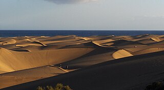
The Maspalomas Dunes are sand dunes located on the south coast of the island of Gran Canaria, Province of Las Palmas, in the Canary Islands. A 404-hectare (1,000-acre) area of the municipality of San Bartolomé de Tirajana, they have been protected as a nature reserve since 1987. They were one of the contenders in the 12 Treasures of Spain competition.

Pilancones Natural Park is located in San Bartolomé de Tirajana municipality on the island of Gran Canaria, Spain. Its area is 5794.4 ha. It adjoins Roque Nublo country park to the north, and Fataga protected area to the east. The park plays an important role in soil protection and the replenishment of an aquifer, along which there are several ravines running southward which are of geomorphological interest and landscape value. The pine forests on hilltops are a well-preserved habitat with abundant bird life. The park also harbours several varieties of cactus and spurge, and a number of aquatic habitats. The park takes its name from natural pools, formerly known locally as pilancones, which remain after the runoff of water. Throughout the area there are threatened animal and plant species, and features of scientific interest.

During August 2019, a number of forest fires broke out in the Canary Islands of Gran Canaria, Tenerife and Lanzarote. The fires on the island of Gran Canaria were the most severe, resulting in the loss of large areas of the island's forests and leading to the evacuation of thousands of residents from a number of towns and villages. The intense heat brought by a heat wave and the presence of strong winds, combined with the island's mountainous terrain, made extinguishing activities exceptionally difficult.

