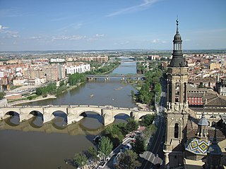
Aragon is an autonomous community in Spain, coextensive with the medieval Kingdom of Aragon. In northeastern Spain, the Aragonese autonomous community comprises three provinces : Huesca, Zaragoza, and Teruel. Its capital is Zaragoza. The current Statute of Autonomy declares Aragon a historic nationality of Spain.

The Kingdom of Aragon was a medieval and early modern kingdom on the Iberian Peninsula, corresponding to the modern-day autonomous community of Aragon, in Spain. It should not be confused with the larger Crown of Aragon, which also included other territories—the Principality of Catalonia, the Kingdom of Valencia, the Kingdom of Majorca, and other possessions that are now part of France, Italy, and Greece—that were also under the rule of the King of Aragon, but were administered separately from the Kingdom of Aragon.
Bajo Cinca or Baix Cinca is a comarca in eastern Aragon, Spain. It is named after river Cinca.

The Principality of Catalonia was a medieval and early modern state in the northeastern Iberian Peninsula. During most of its history it was in dynastic union with the Kingdom of Aragon, constituting together the Crown of Aragon. Between the 13th and the 18th centuries, it was bordered by the Kingdom of Aragon to the west, the Kingdom of Valencia to the south, the Kingdom of France and the feudal lordship of Andorra to the north and by the Mediterranean Sea to the east. The term Principality of Catalonia was official until the 1830s, when the Spanish government implemented the centralized provincial division, but remained in popular and informal contexts. Today, the term Principat (Principality) is used primarily to refer to the autonomous community of Catalonia in Spain, as distinct from the other Catalan Countries, and usually including the historical region of Roussillon in Southern France.
The Noguera Ribagorzana or Noguera Ribagorçana is a river in northern Spain.

Ponts is a municipality and a town in the comarca of the Noguera in the province of Lleida, Catalonia, Spain. It is situated on the left bank of the Segre river near its confluence with the Llobregós river and at the point where the routes from Calaf and Cervera meet the route from Lleida to La Seu d'Urgell.

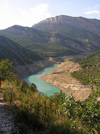
Fígols i Alinyà is a municipality in the comarca of the Alt Urgell in Catalonia, Spain. It is situated on the left bank of the Segre river between Coll de Nargó and Organyà, just above the Oliana reservoir. The municipality was formed in 1972 by the merger of the municipalities of Fígols d'Organyà and Alinyà: the ajuntament is in Fígols. A local road links the municipality with Organyà.

The Arga is a river of Navarre, in Spain, and is a tributary of the Aragón River, itself a tributary of the river Ebro. The Arga was known as the river Runa in antiquity. Situated in the north-east of Spain, the river stretches some 145 kilometres (90 mi) and has a basin of 2,759 square kilometres (1,065 sq mi), of which 2,652 square kilometres (1,024 sq mi) is in Navarre and the remaining 107 square kilometres (41 sq mi) is in the province of Alava. The source of the river is to the north of the village Esteríbar, near the border with France, and it empties into the Aragón River near Funes.

Saucedilla is a municipality located in the province of Cáceres, Extremadura, Spain. It belongs to the Campo Arañuelo County, the capital of which is Navalmoral de la Mata.

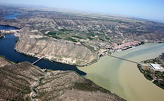
Fayón or Faió is a municipality located in the province of Zaragoza, Aragon, Spain. According to the 2004 census (INE), the municipality has a population of 395 inhabitants. This town is located between the Ebro and the Matarranya rivers in La Franja area; the local dialect is a variant of Catalan.
The Ebro is a river of the north and northeast of the Iberian Peninsula, in Spain. It rises in Cantabria and flows 930 kilometres (580 mi), almost entirely in an east-southeast direction. It flows into the Mediterranean Sea, forming a delta in the Province of Tarragona, in southern Catalonia. In the Iberian peninsula, it ranks second in length after the Tagus and second in discharge volume, and drainage basin, after the Douro. It is the longest river entirely within Spain; the other two mentioned flow into Portugal. It is also the second-longest river in the Mediterranean basin, after the Nile.

The Almonacid de la Cuba Dam was a Roman gravity dam in Almonacid de la Cuba, Zaragoza province, Aragon, Spain, dating to the 1st century AD.
The Ermita de la Virgen del Pilar Dam was a Roman gravity dam in Teruel province, Aragon, Spain, dating to the 1st or 2nd century AD.
The Puy Foradado Dam was a Roman arch-gravity dam in Zaragoza province, Aragon, Spain, dating to the 2nd or 3rd century AD.

Mequinenza Dam is a concrete gravity dam in the province of Zaragoza, Spain. It impounds the Ebro creating a large reservoir, which is called Mar de Aragón. About 35 km downstream of Mequinenza dam is Ribarroja dam.

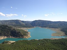
Canelles is a locality located in the municipality of Fígols i Alinyà, in Province of Lleida province, Catalonia, Spain. As of 2020, it has a population of 4.

The Yesa Reservoir is located in the Pyrenees, and is formed with the damming of the Aragon River, in the Navarre town of Yesa (Spain), although the largest area of the reservoir is located in the province of Zaragoza, extending from east to west. It is located to the northwest of the Aragonese province of Zaragoza and to the east of Navarre. Most of it floods lands of the Berdun Canal, in the Aragonese region of Jacetania in the municipalities of Sigüés, Ruesta, Escó, and Tiermas. It is known by the nickname Mar de los Pirineos and is located at the entrance of the aforementioned. It is the largest navigable area of Aragon and it is the source of the Bardenas Canal that transfers water to the Ribera area south of Navarra and irrigates the Bardenas Reales and the Cinco Villas region of Zaragoza. It is also used for water supply and as a power station.