Canisteo Center, New York

Last updated
Canisteo Center, New York
Lossy-page1-7230px-Canisteo (Village); Canisteo Business Notices. NYPL1603021 (cropped).jpg
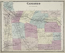
1873 map showing Canisteo Center (then called Center Canisteo)
USA New York location map.svg
Red pog.svg
Canisteo Center
Location in New York
Usa edcp location map.svg
Red pog.svg
Canisteo Center
Location in United States
Coordinates: 42°15′56″N77°34′44″W / 42.26556°N 77.57889°W / 42.26556; -77.57889 Coordinates: 42°15′56″N77°34′44″W / 42.26556°N 77.57889°W / 42.26556; -77.57889
Country United States
State New York
County Steuben
Elevation
1,135 ft (346 m)
Time zone UTC-5 (Eastern (EST))
  Summer (DST) UTC-4 (EDT)
ZIP code
14823
Area code(s) 607

Canisteo Center, New York is the original location of the Village of Canisteo, at the intersection of Canisteo River Road and Steuben County road 119. It was never incorporated.

Canisteo (village), New York Village in New York, United States

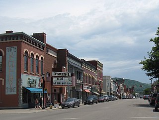
Canisteo is a village in Steuben County, New York, United States. The population was 2,336 at the 2000 census.

Steuben County, New York County in the United States

Steuben County is a county located in the U.S. state of New York. As of the 2010 census, the population was 98,990. Its county seat is Bath. Its name is in honor of Baron von Steuben, a German general who fought on the American side in the American Revolutionary War, though it is not pronounced the same. There is no direct link between the Baron von Steuben and modern Steuben County, which he never visited.

When the Erie Railroad was built about 1860, there was not room for a depot between the tracks and the Canisteo River, so the depot (vacant for decades and demolished in the late 20th century) was built two miles upriver. The Village of Canisteo reestablished itself near the depot.

Erie Railroad former railroad that operated in the northeastern United States

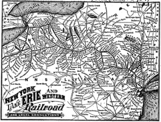
The Erie Railroad was a railroad that operated in the northeastern United States, originally connecting New York City — more specifically Jersey City, New Jersey, where Erie's former terminal, long demolished, used to stand — with Lake Erie. It expanded west to Chicago with its 1941 merger with the former Atlantic and Great Western Railroad, also known as the New York, Pennsylvania and Ohio Railroad. Its mainline route proved influential in the development and economic growth of the Southern Tier, including cities such as Binghamton, Elmira, and Hornell. The Erie Railroad repair shops were located in Hornell, and were Hornell's largest employer. Hornell was also where Erie's main line split into two routes, one north to Buffalo and the other west to Cleveland.

Canisteo River river in the United States of America

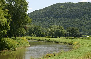
The Canisteo River is a 61.0-mile-long (98.2 km) tributary of the Tioga River in western New York in the United States. It drains a dissected plateau, a portion of the northern Allegheny Plateau southwest of the Finger Lakes region, in the far northwestern reaches of the watershed of the Susquehanna River.

Canisteo Center had a post office, called Center Canisteo, from 1851 to 1876. [1] Since the 19th century Canisteo Center has been a hamlet.

Hamlet (place) small settlement in a rural area

A hamlet is a small human settlement. In different jurisdictions and geographies, hamlets may be the size of a town, village or parish, be considered a smaller settlement or subdivision or satellite entity to a larger settlement. The word and concept of a hamlet have roots in the Anglo-Norman settlement of England, where the old French hamlet came to apply to small human settlements. In British geography, a hamlet is considered smaller than a village and distinctly without a church.

So as to avoid confusion with Canisteo, in the later 20th century Canisteo Center was given the name of Carter.

Related Research Articles

Greenwood, New York Town in New York, United States

Greenwood is a town in Steuben County, New York, United States. The population was 849 at the 2000 census.

Hornell, New York City in New York, United States

Hornell is a city in Steuben County, New York, United States. The population was 8,563 at the 2010 census. The city is named after the Hornell family, early settlers.

Hornellsville, New York Town in New York, United States

Hornellsville is a town in Steuben County, New York, United States. United States. The population, not counting the city of Hornell, was 4,151 at the 2000 census. The name is taken from a prominent pioneer family.

Wellsville (village), New York Village in New York, United States

Wellsville is a village in Allegany County, New York, United States. Located in south-central wooded and rural Allegany County, it is the largest population and business center in a 30-mile (48 km) radius. The population was 4,679 at the 2010 census. The village's name is not, as some suppose, derived from the oil wells that became an important economic part of the area, but rather for Gardiner Wells, a local businessman.

Canisteo, New York Town in New York, United States

Canisteo is a town in Steuben County, New York, United States. The population was 3,391 at the 2010 census. The name was taken from a former Indian village located here.

Tioga River (Chemung River tributary) river in the United States of America

The Tioga River is a tributary of the Chemung River, approximately 58 miles (93 km) long, in northern Pennsylvania and western New York in the United States. It drains a region of ridges in the northern Allegheny Plateau in the watershed of the Susquehanna River. It is a Northern flowing river

New York State Route 36 highway in New York

New York State Route 36 (NY 36) is a north–south state highway in the western part of New York in the United States. The highway extends for 95 miles (153 km) from the Pennsylvania state line at Troupsburg, Steuben County northward to Ogden, Monroe County, where it ends at an intersection with NY 31. Along the way, NY 36 passes through the villages of Canisteo, Dansville, Mount Morris, Caledonia, and Churchville and the city of Hornell. The section of the route between Dansville and Mount Morris closely parallels Interstate 390 (I-390); however, from Dansville south and Mount Morris north, NY 36 serves as a regionally important highway, connecting to I-86, U.S. Route 20A (US 20A), US 20, and I-490 as it heads north. At its south end, NY 36 connects to Pennsylvania Route 249 (PA 249).

New York State Route 248 highway in New York

New York State Route 248 (NY 248) is a state highway in a remote part of the Southern Tier region of New York in the United States. The route, located close to the Pennsylvania state line, passes through Allegany and Steuben counties. In the former, it runs mostly east–west from its junction with NY 19 in Stannards; but in the latter turns northwards to its north end at NY 36 in Canisteo. NY 248 used to be signed north-south in Steuben County, however, those designators were replaced by new east-west signage about 2013.

New York State Route 417 highway in New York

New York State Route 417 (NY 417) is an east–west state highway located in the Southern Tier of New York in the United States. It begins at exit 20 of the Southern Tier Expressway in the city of Salamanca and ends at a junction with NY 415 in Painted Post, west of the city of Corning. At 105.25 miles (169.38 km) in length, NY 417 is the longest of the state highways that were formerly part of NY 17 before the construction of the Southern Tier Expressway. It also diverges the most from the current NY 17, coming within 100 feet (30 m) of the Pennsylvania state line at one intersection.

New York State Route 17F (NY 17F) was a state highway located in the Southern Tier of New York in the United States. The western terminus of the route was at then-NY 17 in Andover, Allegany County. The eastern terminus was at NY 17 in Addison, Steuben County. NY 17F was an alternate to NY 17 between the two locations, branching north to serve Almond, Hornell, and Canisteo.

Metz, Indiana Unincorporated community in Indiana, United States

Metz is an unincorporated community in York Township, Steuben County, in the U.S. state of Indiana.

Benjamin Patterson Inn

Benjamin Patterson Inn, also known as Jenning's Tavern, is a historic inn and tavern located at Corning in Steuben County, New York. It is a two-story, ell shaped frame structure in the Federal style. Built in 1796, it is the oldest frame building in the area and perhaps all of Steuben County.

The Hornell Traction Company was an electric streetcar company serving Hornell and Canisteo, New York. Two companies with the same owners were created the same day in 1892: the Hornellsville Electric Railway and the Hornellsville & Canisteo Railway. Service on the Canisteo line began December 22, 1892. Construction was completed in 1893. A branch was built in 1894 to Babcock's Track, a horse race track, of which there is a drawing but whose exact location is not known. Both companies shared facilities in Hornell. The companies owned 15 miles (24 km) of track.

Cameron Mills, New York Hamlet in New York, United States

Cameron Mills is a hamlet in Steuben County, New York, United States. The community is located along the Canisteo River 8.5 miles (13.7 km) northwest of Addison. Cameron Mills has a post office with ZIP code 14820, which opened on March 19, 1850.

The McBurney House is the oldest surviving house in Steuben County, New York. Located at 5872 Dineen Road, Canisteo, New York and currently in the town of Hornellsville, New York.

South Canisteo, New York Hamlet in New York, United States

South Canisteo, New York is a hamlet in the Town of Canisteo, about 6 miles (9.7 km) SE of the Village of Canisteo. It is located on New York Route 36 at its intersection with Steuben County route 21, Hog Back Road, and Steuben County route 31.

References

  1. "Post Offices - New York - Steuben County". Jim Forte Postal History. Retrieved April 15, 2019.